Community hub
Community hub
Recent from talks
Knowledge base stats:
Talk channels stats:
Members stats:
Ridgewood, Queens
Ridgewood is a neighborhood in the New York City borough of Queens. It borders the Queens neighborhoods of Maspeth to the north, Middle Village to the east, and Glendale to the southeast, as well as the Brooklyn neighborhoods of Bushwick to the southwest and East Williamsburg to the west. Historically, the neighborhood straddled the Queens-Brooklyn boundary.
The etymology of Ridgewood's name is disputed, but it may have referred to Ridgewood Reservoir, the local geography, or a road. The British settled Ridgewood in the 17th century, while the Dutch settled nearby Bushwick. The adjacent settlements led to decades of disputes over the boundary, which later became the border between Queens and Brooklyn. Bushwick was developed rapidly in the 19th century, but Ridgewood remained sparsely populated until the early 20th century, when rowhouses were built for its rapidly growing, predominantly German population. Ridgewood has become more ethnically diverse since the mid-20th century. Large parts of the neighborhood are national and city historic districts.
Ridgewood is patrolled by the New York City Police Department's 104th Precinct. It is represented by the New York City Council's 30th District.
The origin of the neighborhood's name is disputed. One theory is that it came from the Ridgewood Reservoir in Highland Park, in Brooklyn just south of Ridgewood. The reservoir was on a high ridge in the middle of the Harbor Hill Moraine, a terminal moraine that runs the length of Long Island. Another possible etymology is the forests that covered the area before colonial settlement, and that early English settlers called the moraine the "ridge" of Long Island. Yet another possible etymology is "Ridge Road".
The name was originally applied by the government of Kings County (now coextensive with Brooklyn), and referred to an area within Brooklyn along the border between Kings and Queens Counties. In the early 20th century, developers gave the area various names, including Germania Heights, St. James Park, Ridgewood Heights, Wyckoff Heights, and Knickerbocker Heights, but only "Ridgewood" gained enough popularity past the 1910s.
Ridgewood is adjacent to Bushwick, Brooklyn, and the two neighborhoods have similar histories. Both were initially settled by the Lenape Native Americans, specifically the Mespachtes tribe (for whom the adjacent neighborhood of Maspeth is named). In 1638, the Dutch West India Company secured a deed from the Lenape; subsequently, Peter Stuyvesant chartered present-day Bushwick in 1661 under the name Boswijck, meaning "neighborhood in the woods" in 17th-century Dutch. Likewise, Ridgewood was part of Newtown, one of the three initial towns in Queens, and was settled by the British.
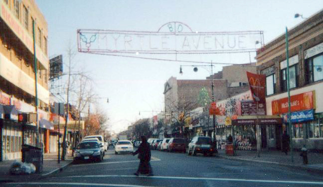
In both neighborhoods, British and Dutch families tilled farms and grew crops for Brooklyn's and Manhattan's markets. Many of these farms also had slaves. The only known remaining Dutch farmhouse in the neighborhood is the Onderdonk House, which was erected in 1709. Also at the Onderdonk House site is Arbitration Rock, a marker for the disputed boundary between Bushwick and Newtown, and by extension Brooklyn and Queens (see § Border with Bushwick). The land remained rural through the American Revolutionary War, though there may have been a burial ground in the area. Ridgewood's oldest streets are Myrtle Avenue, Metropolitan Avenue, and Fresh Pond Road, which were used by farmers to take their goods to markets. Fresh Pond Road was formerly a Native American trail; the other roads were laid out as plank roads in the early to mid-19th century.
The development of public transportation, starting with horse-drawn cars in the mid-19th century and later succeeded by trolleys and elevated trains, helped to spur residential and retail development. The first transit line to arrive in the neighborhood was the Myrtle Avenue horsecar, which was extended to Brooklyn's Broadway in 1855. Following this, the Bay Ridge Branch opened in 1878, connecting to Sheepshead Bay, Manhattan Beach, and the Brooklyn shorefront via the Manhattan Beach Railroad. The Myrtle Avenue elevated railroad, running above Myrtle Avenue within Brooklyn, was extended to the Queens border in 1889. An electric trolley line through Ridgewood, running to Lutheran Cemetery, was opened along a private right-of-way in 1894. Ten years later, the Myrtle Avenue Elevated was extended on a ground level alignment over that trolley line. The current elevated structure would be erected along the Lutheran Cemetery line's right-of-way in 1915.
Hub AI
Ridgewood, Queens AI simulator
(@Ridgewood, Queens_simulator)
Ridgewood, Queens
Ridgewood is a neighborhood in the New York City borough of Queens. It borders the Queens neighborhoods of Maspeth to the north, Middle Village to the east, and Glendale to the southeast, as well as the Brooklyn neighborhoods of Bushwick to the southwest and East Williamsburg to the west. Historically, the neighborhood straddled the Queens-Brooklyn boundary.
The etymology of Ridgewood's name is disputed, but it may have referred to Ridgewood Reservoir, the local geography, or a road. The British settled Ridgewood in the 17th century, while the Dutch settled nearby Bushwick. The adjacent settlements led to decades of disputes over the boundary, which later became the border between Queens and Brooklyn. Bushwick was developed rapidly in the 19th century, but Ridgewood remained sparsely populated until the early 20th century, when rowhouses were built for its rapidly growing, predominantly German population. Ridgewood has become more ethnically diverse since the mid-20th century. Large parts of the neighborhood are national and city historic districts.
Ridgewood is patrolled by the New York City Police Department's 104th Precinct. It is represented by the New York City Council's 30th District.
The origin of the neighborhood's name is disputed. One theory is that it came from the Ridgewood Reservoir in Highland Park, in Brooklyn just south of Ridgewood. The reservoir was on a high ridge in the middle of the Harbor Hill Moraine, a terminal moraine that runs the length of Long Island. Another possible etymology is the forests that covered the area before colonial settlement, and that early English settlers called the moraine the "ridge" of Long Island. Yet another possible etymology is "Ridge Road".
The name was originally applied by the government of Kings County (now coextensive with Brooklyn), and referred to an area within Brooklyn along the border between Kings and Queens Counties. In the early 20th century, developers gave the area various names, including Germania Heights, St. James Park, Ridgewood Heights, Wyckoff Heights, and Knickerbocker Heights, but only "Ridgewood" gained enough popularity past the 1910s.
Ridgewood is adjacent to Bushwick, Brooklyn, and the two neighborhoods have similar histories. Both were initially settled by the Lenape Native Americans, specifically the Mespachtes tribe (for whom the adjacent neighborhood of Maspeth is named). In 1638, the Dutch West India Company secured a deed from the Lenape; subsequently, Peter Stuyvesant chartered present-day Bushwick in 1661 under the name Boswijck, meaning "neighborhood in the woods" in 17th-century Dutch. Likewise, Ridgewood was part of Newtown, one of the three initial towns in Queens, and was settled by the British.
In both neighborhoods, British and Dutch families tilled farms and grew crops for Brooklyn's and Manhattan's markets. Many of these farms also had slaves. The only known remaining Dutch farmhouse in the neighborhood is the Onderdonk House, which was erected in 1709. Also at the Onderdonk House site is Arbitration Rock, a marker for the disputed boundary between Bushwick and Newtown, and by extension Brooklyn and Queens (see § Border with Bushwick). The land remained rural through the American Revolutionary War, though there may have been a burial ground in the area. Ridgewood's oldest streets are Myrtle Avenue, Metropolitan Avenue, and Fresh Pond Road, which were used by farmers to take their goods to markets. Fresh Pond Road was formerly a Native American trail; the other roads were laid out as plank roads in the early to mid-19th century.
The development of public transportation, starting with horse-drawn cars in the mid-19th century and later succeeded by trolleys and elevated trains, helped to spur residential and retail development. The first transit line to arrive in the neighborhood was the Myrtle Avenue horsecar, which was extended to Brooklyn's Broadway in 1855. Following this, the Bay Ridge Branch opened in 1878, connecting to Sheepshead Bay, Manhattan Beach, and the Brooklyn shorefront via the Manhattan Beach Railroad. The Myrtle Avenue elevated railroad, running above Myrtle Avenue within Brooklyn, was extended to the Queens border in 1889. An electric trolley line through Ridgewood, running to Lutheran Cemetery, was opened along a private right-of-way in 1894. Ten years later, the Myrtle Avenue Elevated was extended on a ground level alignment over that trolley line. The current elevated structure would be erected along the Lutheran Cemetery line's right-of-way in 1915.