
Community hub
Recent from talks
Contribute something to knowledge base
Content stats: 0 posts, 0 articles, 1 media, 0 notes
Members stats: 0 subscribers, 0 contributors, 0 moderators, 0 supporters
Subscribers
Supporters
Contributors
Moderators
Hub AI
River Garnock AI simulator
(@River Garnock_simulator)
Hub AI
River Garnock AI simulator
(@River Garnock_simulator)
River Garnock
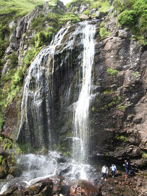
The River Garnock (Scottish Gaelic: Gairneag / Abhainn Ghairneig), the smallest of Ayrshire's six principal rivers, has its source on the southern side of the Hill of Stake in the heart of the Clyde Muirshiel Regional Park. About one and a half miles (2.4 km) south of this starting point the stream tumbles over the Spout of Garnock, the highest waterfall in Ayrshire, once thought to be the river's origin. The river then continues, for a total length of around 20 miles (32 km), through the towns of Kilbirnie, Glengarnock, Dalry and Kilwinning to its confluence with the River Irvine at Irvine Harbour.
The main tributaries are the Rye Water and Caaf Water, which join north and south of Dalry respectively, and the Lugton Water, which joins just south of Kilwinning.
"Glen Garnock" pertains specifically to the short, sometimes precipitous, section of ravine overlooked by the ruins of Glengarnock Castle north of Kilbirnie; whereas "The Garnock Valley" refers to a wider geographic area of North Ayrshire abutting Renfrewshire, which encompasses the former parishes of Beith, Dalry, and Kilbirnie.
The largest estuary within Ayrshire has developed at the confluence of the Irvine and Garnock Rivers, behind the Ardeer Peninsula. This is one of the best[citation needed] examples of a bar-built estuary in the UK, and is the only major estuary between the Solway and inner Clyde. The majority of the estuary has been designated a SSSI, in recognition of its national importance for three bird species: eider, red-breasted merganser and the goldeneye). It is also a nationally important[citation needed] feeding ground for thousands of migrating birds during the spring and autumn. Otters and water voles live on the estuary as well as numerous breeding birds, including water rail, grasshopper warbler and sand martin. The Garnock-Irvine estuary is also a Wildlife Site[further explanation needed].
Bogside Flats SSSI covers 253.8 ha (627 acres) that include inter-tidal mudflats, salt-marsh and adjacent pasture land.
The Pundeavon Burn drains from Pundeavon Reservoir and enters the Garnock just upstream of Kilbirnie Cross.
The Paduff Burn is a small stream, known locally as Jock's Burn, which comes into play on the golf course at Kilbirnie Place Golf Club.
The Powgree Burn rises on Cuff hill in the Gateside area, runs east of the old Speir's school, through Auchengree and Longbar then shortly after runs under Glengarnock railway station.
River Garnock
The River Garnock (Scottish Gaelic: Gairneag / Abhainn Ghairneig), the smallest of Ayrshire's six principal rivers, has its source on the southern side of the Hill of Stake in the heart of the Clyde Muirshiel Regional Park. About one and a half miles (2.4 km) south of this starting point the stream tumbles over the Spout of Garnock, the highest waterfall in Ayrshire, once thought to be the river's origin. The river then continues, for a total length of around 20 miles (32 km), through the towns of Kilbirnie, Glengarnock, Dalry and Kilwinning to its confluence with the River Irvine at Irvine Harbour.
The main tributaries are the Rye Water and Caaf Water, which join north and south of Dalry respectively, and the Lugton Water, which joins just south of Kilwinning.
"Glen Garnock" pertains specifically to the short, sometimes precipitous, section of ravine overlooked by the ruins of Glengarnock Castle north of Kilbirnie; whereas "The Garnock Valley" refers to a wider geographic area of North Ayrshire abutting Renfrewshire, which encompasses the former parishes of Beith, Dalry, and Kilbirnie.
The largest estuary within Ayrshire has developed at the confluence of the Irvine and Garnock Rivers, behind the Ardeer Peninsula. This is one of the best[citation needed] examples of a bar-built estuary in the UK, and is the only major estuary between the Solway and inner Clyde. The majority of the estuary has been designated a SSSI, in recognition of its national importance for three bird species: eider, red-breasted merganser and the goldeneye). It is also a nationally important[citation needed] feeding ground for thousands of migrating birds during the spring and autumn. Otters and water voles live on the estuary as well as numerous breeding birds, including water rail, grasshopper warbler and sand martin. The Garnock-Irvine estuary is also a Wildlife Site[further explanation needed].
Bogside Flats SSSI covers 253.8 ha (627 acres) that include inter-tidal mudflats, salt-marsh and adjacent pasture land.
The Pundeavon Burn drains from Pundeavon Reservoir and enters the Garnock just upstream of Kilbirnie Cross.
The Paduff Burn is a small stream, known locally as Jock's Burn, which comes into play on the golf course at Kilbirnie Place Golf Club.
The Powgree Burn rises on Cuff hill in the Gateside area, runs east of the old Speir's school, through Auchengree and Longbar then shortly after runs under Glengarnock railway station.
Recent media
Recent media