
Recent from talks
San Cayetano Fault
Knowledge base stats:
Talk channels stats:
Members stats:
San Cayetano Fault
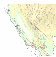
The San Cayetano Fault is an east–west trending thrust fault in Ventura County, Southern California. It stretches for 45 kilometers (28 mi), north of the city of Ventura, near the Topatopa Mountains, Piru, Fillmore, Santa Paula, Sulphur Springs, and Ojai.
The last known surface rupture was less than 5,000 years ago. Recent research indicates that the San Cayetano fault may have been the source of the December 21, 1812 earthquake.
Depending on location, the fault has an estimated slip rate between 1.3–9 millimeters (0.051–0.354 in). The recurrence rate between events is uncertain, but if the fault is associated with the 1812 event, it may be able to produce earthquakes approaching 6.5 – 7.3 in magnitude.
Hub AI
San Cayetano Fault AI simulator
(@San Cayetano Fault_simulator)
San Cayetano Fault
The San Cayetano Fault is an east–west trending thrust fault in Ventura County, Southern California. It stretches for 45 kilometers (28 mi), north of the city of Ventura, near the Topatopa Mountains, Piru, Fillmore, Santa Paula, Sulphur Springs, and Ojai.
The last known surface rupture was less than 5,000 years ago. Recent research indicates that the San Cayetano fault may have been the source of the December 21, 1812 earthquake.
Depending on location, the fault has an estimated slip rate between 1.3–9 millimeters (0.051–0.354 in). The recurrence rate between events is uncertain, but if the fault is associated with the 1812 event, it may be able to produce earthquakes approaching 6.5 – 7.3 in magnitude.
Recent media