Hubbry Logo
Section (United States land surveying)Section (United States land surveying)Main
Open search
Section (United States land surveying)
Community hub
Section (United States land surveying)
logo
8 pages, 0 posts
0 subscribers
Be the first to start a discussion here.
Section (United States land surveying)
from Wikipedia
Sectioning a township (36 sections).
Perfectly square 160-acre quarter sections of farmland cover central Indiana.
Satellite image of crops growing in southwest Kansas, mainly using center pivot irrigation. The primary grid pattern is of quarter sections (12 mi × 12 mi (800 m × 800 m)).

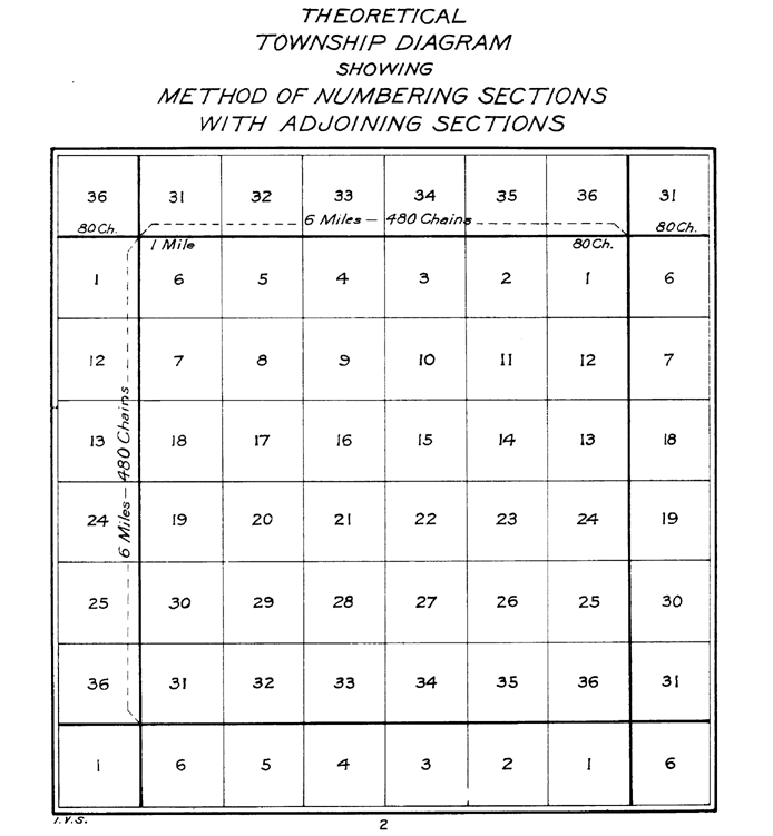
In U.S. land surveying under the Public Land Survey System (PLSS), a section is an area nominally one square mile (2.6 square kilometers), containing 640 acres (260 hectares), with 36 sections making up one survey township on a rectangular grid.[1]

The legal description of a tract of land under the PLSS includes the name of the state, name of the county, township number, range number, section number, and portion of a section. Sections are customarily surveyed into smaller squares by repeated halving and quartering. A quarter section is 160 acres (65 ha) and a "quarter-quarter section" is 40 acres (16 ha). In 1832 the smallest area of land that could be acquired was reduced to the 40-acre (16 ha) quarter-quarter section, and this size parcel became entrenched in American mythology. After the Civil War, freedmen (freed slaves) were reckoned to be self-sufficient with "40 acres and a mule," though they never received it. In the 20th century real estate developers preferred working with 40-acre (16 ha) parcels.[2] The phrases "front 40" and "back 40," referring to farm fields, indicate the front and back quarter-quarter sections of land.

One of the reasons for creating sections of 640 acres (260 ha) was the ease of dividing into halves and quarters while still maintaining a whole number of acres. A section can be halved seven times in this way, down to a 5-acre (2 ha) parcel, or half of a quarter-quarter-quarter section—an easily surveyed 50-square-chain (2 ha) area. This system was of great practical value on the American frontier, where surveyors often had a shaky grasp of mathematics and were required to work quickly.[2]

A description of a quarter-quarter section in standard abbreviated form, might look like "NW 1/4, NE 1/4, Sec. 34, T.3S, R.1W, 1st P.M." or, alternatively, "34-3-1 NW4NE4 1PM". In expanded form, this would read:

The Northwest quarter of the Northeast quarter of Section 34 of Township 3 South, Range 1 West, first Principal Meridian.[3]

History

[edit]

The existence of section lines made property descriptions far more straightforward than the old metes and bounds system. The establishment of standard east-west and north-south lines ("township" and "range lines") meant that deeds could be written without regard to temporary terrain features such as trees, piles of rocks, fences, and the like, and be worded in the style such as "Lying and being in Township 4 North; Range 7 West; and being the northwest quadrant of the southwest quadrant of said section," an exact description in this case of 40 acres, as there are 640 acres (260 ha) in a square mile.

The importance of "sections" was greatly enhanced by the passage of "An Ordinance for ascertaining the mode of disposing of lands in the Western Territory" of 1785 by the U.S. Congress (see Land Ordinance of 1785). This law provided that lands outside the then-existing states could not be sold, otherwise distributed, or opened for settlement prior to being surveyed. The standard way of doing this was to divide the land into sections. An area of six sections by six sections would define a township. Within this area, one section (section 16) was designated as school land. As the entire parcel would not be necessary for the school and its grounds, the balance of it was to be sold, with the monies to go into the construction and upkeep of the school. Section 36 was also subsequently added as a school section in western states.[4] The ordinance also specified that out of every township, the four lots, being numbered 8, 11, 26, 29, and out of every fractional part of a township, so many lots of the same numbers as shall be found thereon, for future sale.[5]

On May 20, 1862, President Abraham Lincoln signed into law the Homestead Act, by which settlers could "claim" 160 acres (a quarter section) of public land. Claimants were required to "live on" and “improve” their plots by cultivating the land. After five years, the original filer of the claim was entitled to the property, free and clear, except for a small registration fee.[6]

Roads and urban planning

[edit]

Numbering within a township

[edit]
Section map of Rock Creek Township, Saunders County, Nebraska (1907)

Every township is divided into 36 sections, each usually 1 mile (1.6 km) square. Sections are numbered boustrophedonically within townships[3] as follows (north at top):

6 5 4 3 2 1
7 8 9 10 11 12
18 17 16 15 14 13
19 20 21 22 23 24
30 29 28 27 26 25
31 32 33 34 35 36

Section subdivisions

[edit]

Sections can be divided into quarter sections of 160 acres (65 ha), named by intercardinal direction (northwest, northeast, etc.). For instance, the southwest quarter of a section is named SW 1/4.[7]

NW NE
SW SE

Sections can be further broken up into 40-acre (16 ha) blocks, or quarter-quarter sections. These add a second intercardinal direction label. For instance, the southeast quarter of the southwest quarter section mentioned above is labeled SE 1/4, SW 1/4:[7][8]

NWNW NENW NWNE NENE
SWNW SENW SWNE SENE
NWSW NESW NWSE NESE
SWSW SESW SWSE SESE

Measurement anomalies

[edit]

The curvature of the Earth makes it impossible to superimpose a regular grid on its surface, as the meridians converge toward the North Pole. As the U.S. is in the Northern Hemisphere, if a section's or township's east and west sides lie along meridians, its north side is shorter than its south side. As sections were surveyed from south and east to north and west, accumulated errors and distortions resulted in the north and west lines, and north and west sections diverged the most from the ideal shape and size.

The entire township grid shifts to account for the Earth's curvature. Where the grid is corrected, or where two grids based on different principal meridians meet, section shapes are irregular.

Sections also differ from the PLSS ideal of one square mile for other reasons, including errors and sloppy work by surveyors, poor instrumentation, and difficult terrain. In addition, the primary survey tool was the magnetic compass, which is influenced by local irregularities.

Once established, even an imperfect grid remains in force, mainly because the monuments of the original survey, when recovered, hold legal precedent over subsequent resurveys.[3]

Alternatives and legacy systems

[edit]

The Public Land Survey System was not the first to define and implement a survey grid. A number of similar systems were established, often using terms like section and township but not necessarily in the same way. For example, the lands of the Holland Purchase in western New York were surveyed into a township grid before the PLSS was established. In colonial New England land was often divided into squares called towns or townships and further subdivided into parcels called lots or sections.[2]

Sections are also used in land descriptions in the portion of northwestern Georgia that was formerly part of the territory of the Cherokee Nation. They are not, however, part of the PLSS and are irregular in shape and size. See Cherokee County, Georgia for more information on the historical reasons for this.

Another exception to the usual use of sections and section numbering occurs when most of a parcel, or lot, falls under a body of water. The term "government lot" is used for such parcels and they are usually described separately from the rest of the section using single numbers (such as "Government Lot 5 of Section 15"). Also, parcels within a platted subdivision are often specified by lot number rather than using PLSS descriptions.[3]

Where Spanish land grants in Florida have descriptions that predate PLSS or even the U.S. itself, deviation from typical section numbering and size and shape often takes place. In an effort to honor these land grants after the U.S. took control of Florida, surveyors would use descriptions from confirmed land grants to establish their initial boundaries and created PLSS sections that extrapolated from those lines. Often, the amount of land left over in areas immediately surrounding the grants was grossly undersized or awkwardly shaped. Those tracts are referred to as "fractional sections" and often are not subject to township or range definitions. An example of such a legal description's beginning would read "Being a portion of Fractional Sec. 59, Township 0 South, Range 0 West".

Also, land north of the Watson Line near the Georgia border was not subject to the standard U.S. section, township and range designations, since the State of Georgia had claimed and laid out counties and surveyed its public lands south of that line into what eventually became part of the State of Florida. The exact location of the Georgia–Florida state line was ultimately confirmed by an Act of Congress, approved April 9, 1872.

See also

[edit]

References

[edit]

Further reading

[edit]
Revisions and contributorsEdit on WikipediaRead on Wikipedia
from Grokipedia
In land surveying, a section is a standardized unit of land comprising one , equivalent to 640 acres, serving as one of the 36 primary subdivisions within a six-mile-square under the (PLSS). The PLSS, enacted through the , imposed a rectangular grid on public domain lands to facilitate orderly division, sale, and settlement of territories acquired after the Revolutionary War. Proposed by , this system replaced irregular colonial surveys with a methodical framework anchored by principal meridians and baselines, enabling precise legal descriptions via , range, and section identifiers. Each typically encompasses 36 sections arranged in a 6-by-6 grid, with section 16 reserved for public , reflecting early federal priorities for institutional support amid westward expansion. The section's uniform dimensions underpin property boundaries, cadastral records, and resource management across approximately 1.5 billion acres surveyed by the and predecessors, forming the foundational cadastral structure for much of the excluding original Atlantic states. Deviations occur in fractional townships due to terrain or prior claims, but the section remains the core aliquot for subdividing into quarters, halves, or smaller lots essential for deeds and titles.

Introduction

Definition and Basic Structure

The (PLSS) is the rectangular coordinate system established by the federal government to subdivide, describe, and manage lands, primarily west of the original . It divides land into a grid based on geographic coordinates rather than , facilitating equitable distribution and legal description of parcels. The system originated from the and has been administered by agencies such as the General Land Office and its successor, the (BLM). At its core, the PLSS is anchored by principal meridians—north-south reference lines—and baselines, which are east-west reference lines intersecting at initial points selected for their geographic and astronomical significance. From these intersections, township lines (parallel to the baseline, spaced 6 miles apart) and range lines (parallel to the meridian, also 6 miles apart) form the primary grid. This creates survey s, each a 6-by-6-mile square encompassing approximately 23,040 acres. Townships are identified by their position relative to the initial point: numbered north or south of the baseline (tier) and east or west of the meridian (range), such as "Township 2 North, Range 3 West." Each is further divided into 36 sections, arranged in a standard numbering pattern from 1 to 36, with each section nominally 1 or 640 acres. Sections along the township's perimeter may be fractional due to convergence of meridians or survey adjustments, but interior sections adhere closely to the standard dimensions. This hierarchical structure enables precise legal descriptions, such as "the northeast quarter of Section 15, Township 2 North, Range 3 West," supporting land transactions, taxation, and across over 30 states.

Historical Purpose and Geographic Scope

The (PLSS), established by the enacted on May 20, 1785, by the , served primarily to create a standardized rectangular grid for surveying, subdividing, and auctioning federal public domain lands acquired through cessions from states and the Treaty of Paris of 1783. This framework addressed the inefficiencies of irregular colonial metes-and-bounds surveys, which had fostered overlapping claims and litigation, by enabling rapid, uniform division into townships of 6 by 6 miles, each containing 36 sections of 640 acres, to facilitate orderly westward expansion, settlement by smallholders, and revenue generation for the cash-strapped federal government at a minimum sale price of $1 per acre. The ordinance also mandated reservations, such as one section per township for public schools, reflecting an intent to support amid settlement. Initially applied to the —encompassing modern , , , , , and parts of —the PLSS's purpose evolved with territorial acquisitions, extending surveys before settlement to preempt disputes and ensure equitable distribution under laws like the of 1787, which prohibited slavery and promoted governance in surveyed areas. By mandating pre-settlement surveys, the system prioritized causal efficiency in land administration, reducing the anarchy seen in unsurveyed regions and enabling the transfer of over 1.8 billion acres of by the early through sales, grants, and . Geographically, the PLSS covers the bulk of federal lands outside the original 13 colonies, where proprietary grants and metes-and-bounds prevailed, spanning principal meridians and base lines across 30 primarily Midwestern, Southern, and Western states including , , , , , , , , , , , , , and much of the trans-Mississippi West up to the Pacific, but excluding (which adopted Spanish and state-specific systems), , (partially surveyed under separate ordinances), , and Alaska's non-PLSS areas. This scope delimits about three-quarters of the contiguous U.S. , with surveys adapting to via meanders and fractional sections, though non-federal or early-state lands often retained irregular patterns. The system's boundaries reflect the public domain's extent, shaped by purchases like the (1803) and (1848), which necessitated over 300 initial points of origin for grids aligned to .

Historical Development

Establishment via the Land Ordinance of 1785

The , passed by the on May 20, 1785, established the initial framework for the rectangular survey system applied to public lands in the western territories ceded by the original states following the Revolutionary War. This legislation addressed the chaotic land claims and irregular boundaries from colonial metes-and-bounds practices by mandating a grid-based division of land into uniform parcels prior to sale, enabling efficient federal revenue through auctions and promoting orderly westward expansion while reducing future disputes. Under the ordinance, surveys divided territory into s six miles square, each containing 36 sections of one (approximately 640 acres), with further potential subdivision into quarter sections of 160 acres. Principal meridians ran north-south along true meridians, intersected by east-west base lines, forming right angles; initial work commenced at the River's intersection with Pennsylvania's western boundary. Corners were marked with notched posts, stones, or earth mounds, and meander lines delineated boundaries along navigable waters greater than 25 acres. The 16th section of each township was reserved for public schools, marking an early provision for funding from land resources. Implementation began with the survey of the Seven Ranges in northeastern , directed by Thomas Hutchins as Geographer of the , covering about 1 million acres east of the and north of the starting in 1786. Lands were sold at minimum one dollar per acre in public auctions, payable in cash or military warrants, with surveys required before settlement to ensure legal title transfer. This system formed the basis of the , eventually encompassing over three-quarters of the continental excluding the original colonies and .

Survey Expansion and Key Surveys

Following the , the initial expansion of the rectangular survey system occurred in the , beginning with the survey of the Seven Ranges in eastern . This pioneering effort, directed by Thomas Hutchins as Geographer of the , commenced on September 30, 1785, north of the and west of Pennsylvania's western boundary. The surveys, conducted by 13 deputy surveyors, divided the land into townships and sections as prescribed, with completion of the Seven Ranges by July 1788, marking the first application of the system to federal public lands. Subsequent surveys in the included the Purchase, contracted on October 27, 1787, and surveyed starting April 7, 1788, under , covering 1.5 million acres around Marietta. The Symmes Purchase between the Great and Little Miami Rivers followed, surveyed from 1788 by Israel Ludlow and completed by 1802, though with noted distortions due to early techniques. Additional key surveys encompassed the Greenville Treaty Line (1797-1800) and U.S. Military Reserve townships (1797-1799), both under Putnam, which facilitated land distribution post-Indian treaties and supported settlement. The in 1803 prompted significant westward expansion, necessitating new principal meridians and base lines to accommodate vast territories. Surveys began in 1805, with the establishment of meridians such as the Second Principal Meridian near , and the Third Principal Meridian at the Ohio River's mouth, extending into and parts of . By 1815, the Fourth Principal Meridian was set at the confluence of the and Mississippi Rivers, governing surveys in , , and northeastern , while the Fifth Principal Meridian at the Arkansas River's mouth covered , , , and portions of surrounding states. Further key surveys in the early included military bounty lands between the St. Francis and Arkansas Rivers (, under William Rector) and extensions into the Orleans Territory ( instructions by Thomas Freeman). The creation of the General Land Office in centralized surveying administration, enabling accelerated campaigns amid territorial acquisitions like ( onward) and ( subdivisions). Challenges arose from terrain variations, inaccurate early chains, and conflicts with Native American lands, yet the system adapted, with over 37 principal meridians eventually established to minimize cumulative errors.
Principal MeridianEstablishment YearInitial PointPrimary Areas Surveyed
Second1805Little Blue River confluence with WabashIndiana, eastern
Third1805Mouth of Ohio RiverSouthern , western
Fourth1815Confluence of and Mississippi Rivers,
Fifth1815Old mouth of , ,
Sixth1855Thirty-eighth parallel, near ,
These meridians formed the backbone of surveys supporting the Homestead Act of 1862 and continental expansion, though western mountainous regions often required modifications.

Integration with Roads, Urban Planning, and Settlement

The (PLSS) facilitated orderly settlement by requiring surveys to precede land sales, dividing unsold public domain into townships and sections for systematic disposal and private ownership, as mandated by the Land Ordinance of 1785. This approach, starting with the "Seven Ranges" in post-1785, enabled the federal government to auction parcels like the Purchase of 964,000 acres in 1787, reducing boundary disputes and promoting stable communities through precise monumentation of corners. By 1862, the Homestead Act further integrated the system, allowing settlers to claim up to 160-acre quarter-sections after improvements, tying expansion to the grid's legal subdivisions. Road development aligned closely with PLSS lines, as section boundaries—spaced one mile apart—provided a ready framework for transportation networks, with field notes from surveys in regions like (1840s) and (1890) documenting existing trails and new following these lines. The Act of July 26, 1866, explicitly granted rights-of-way for highways along section lines, typically 66 feet wide in areas like (1871), fostering a rectilinear rural road grid across the Midwest and that enhanced access to surveyed lands. Later, the Act of May 2, 1890, reserved 4-rod-wide roadways in , embedding the grid into infrastructure planning to support agricultural settlement. In , the PLSS influenced town platting through dedicated townsites, where sections were subdivided into blocks, lots, and streets aligned with grids, as per protocols in the Manual of Surveying Instructions. Early examples include (founded April 7, 1788), and (surveyed 1810), which used the rectangular system for lot divisions and reserved spaces like Lot 16 for public use such as schools. Cities like adopted this grid, with surveyor James Thompson's 1830 plan overlaying streets on section lines from the 1785 ordinance, creating a uniform urban layout that extended the rural survey into commercial development. This integration minimized irregularities, enabling efficient expansion, though adaptations for natural features like rivers required meander lines to maintain the system's regularity.

Core Technical Framework

Township Organization and Numbering

In the (PLSS), form the primary grid units, each nominally measuring 6 miles by 6 miles and subdivided into 36 sections of 1 . These are organized into a rectangular coordinate framework originating from an initial point where a principal meridian (a north-south reference line) intersects a baseline (an east-west reference line). exteriors are established by running lines parallel to the baseline (east-west lines) at 6-mile intervals north and south, and lines parallel to the principal meridian (north-south range lines) at 6-mile intervals east and west. Tiers of townships, which represent east-west rows, are numbered consecutively north or south from the baseline, beginning with Tier 1 (T. 1 N. or T. 1 S.). For instance, T. 2 N. denotes the second tier north of the baseline, located approximately 6 to 12 miles north. Ranges, which form north-south columns, are similarly numbered east or west from the principal meridian, starting at Range 1 (R. 1 E. or R. 1 W.). A specific township is thus identified by combining its tier and range designations, such as T. 5 N., R. 3 W., relative to a named principal meridian like the Fifth Principal Meridian. This system ensures systematic location across surveyed public lands, with multiple principal meridians and baselines established over time to cover regions like the Northwest Territory and beyond. The numbering convention traces to the , which directed the division of unsold western lands into townships progressively numbered from designated lines, facilitating orderly sales and settlement. In practice, to mitigate Earth's curvature, standard parallels (additional east-west correction lines) are set approximately every 24 miles north of the baseline, and guide meridians every 24 miles east or west of the principal meridian, forming larger 24-by-24-mile quadrangles subdivided into 16 townships. Fractional or irregular townships, resulting from natural boundaries or prior claims, retain the same tier and range numbering but may contain fewer than 36 full sections, with deficiencies allocated to boundary lots. Official plats and field notes from the document these designations, preserving the grid's integrity for legal descriptions.

Section Layout and Standard Dimensions

In the (PLSS), are subdivided into 36 sections forming a 6-by-6 grid, each section nominally one in area. The sections are numbered from 1 to 36 following a pattern, which alternates direction row by row to mimic traditional plowing practices: starting with section 1 in the northeast corner and proceeding westward to section 6 in the northwest corner of the northern tier, then southward to the second tier and eastward to section 12, continuing alternately until section 36 in the southeast corner. Standard section dimensions are one statute mile (5,280 feet) along each side, measured using where 80 chains equal one mile, with each chain comprising 66 feet or 100 links. This configuration yields an area of 640 acres per section, subdivided further into quarter sections of 160 acres at 40-chain intervals. Section lines are established true north-south and east-west, with corners marked by posts, stones, or mounds accompanied by bearing trees or pits for reference. While nominal, these dimensions incorporate tolerances for errors and terrain variations; for instance, north-south section lines measure exactly 80 chains except along northern boundaries, and east-west lines approximate the southern boundary length within specified limits. Deviations arise from cumulative measurement discrepancies, meridian convergence, and natural features, leading to fractional sections along edges where excess or deficiency is allocated to lots rather than altering standard interiors. Official protocols, as outlined in the Manual of Instructions, mandate precise field notes recording chainage, bearings, and monuments to ensure retraceability.

Subdivisions and Parceling

Aliquot Parts and Quartering

Aliquot parts in the United States Public Land Survey System (PLSS) denote the fractional subdivisions of a standard section, achieved through successive halving and quartering to create equal legal parcels. These parts enable concise land descriptions, such as the northeast quarter (NE¼) of a section, avoiding the need for detailed angular or linear measurements typical in systems. The system prioritizes aliquot divisions for their simplicity and equity in apportioning public lands, with the section—nominally 640 acres—serving as the primary unit. Quartering establishes the foundational subdivisions by running a north-south meridian and an east-west parallel through the section's center, yielding four quadrants: the northwest quarter (NW¼), northeast quarter (NE¼), southwest quarter (SW¼), and southeast quarter (SE¼), each encompassing 160 acres in a regular section. Further quartering of these 160-acre quarters produces 40-acre quarter-quarters (e.g., NE¼NE¼), continuing hierarchically for smaller parcels as required by land patents or sales. This methodical process ensures uniformity, with descriptions written from the whole to the part, such as "the south half of the northwest quarter" (S½NW¼), and commas separating non-contiguous aliquots (e.g., NE¼, SW¼). The use of aliquot parts assumes proportional division based on cardinal directions, promoting unambiguous property identification in legal conveyances and titles. While aliases like "northeast quarter-section" are interchangeable with fractional notation in descriptions, the latter predominates in official records for precision. In practice, aliquot parts apply primarily to regular sections; fractional or irregular sections often employ numbered lots instead, preserving the system's adaptability to variations. This framework, codified in federal surveying manuals, underpins much of rural land parceling across the PLSS-covered states.

Handling Irregular or Fractional Sections

Fractional sections in the (PLSS) are those containing less than 640 acres, typically resulting from disruptions such as meanderable water bodies, prior land grants, reservations, or irregular boundaries that prevent full rectangular subdivision. These sections arise primarily along the north and west edges of s or where natural features encroach, leading to incomplete exterior lines or missing quarter corners. Irregular sections, often overlapping in description with fractionals, refer to those with distorted shapes or protracted outlying areas due to survey limitations or environmental factors, requiring non-standard subdivision to approximate aliquot parts. Subdivision of fractional sections prioritizes creating as many regular aliquot parts—such as quarter-sections (160 acres) or quarter-quarter-sections (40 acres)—as feasible, with residual areas designated as numbered lots. Lines are run north-south for quarter-sections and east-west for smaller divisions, terminating at irregular boundaries like meander lines, with excess or deficiency in measurements proportionately distributed against the irregular perimeter rather than interior lines. For sections lacking opposing boundaries, parallel lines are employed per early statutes like the Act of 1805, or weighted mean bearings are used for centerlines to align with official plats. Lots are formed for areas under 40 acres or highly irregular remnants, aiming for equitable shapes typically between 10 and 50 acres to avoid impractical parcels. Numbering of lots in fractional sections begins sequentially with Lot 1 in the northeast portion, progressing east-to-west or north-to-south, using the next available number beyond any from the original survey (e.g., starting at 37 for protracted tracts). Areas are computed to the nearest 0.01 acre based on field and plats, with descriptions specifying lot numbers alongside , range, and section for legal identification. In resurveys, existing rights are protected by retracing original monuments and , applying single proportionate measurement between known corners to fix lost ones without altering established subdivisions. For meandered fractional sections, remeandering may update boundaries to the current , creating new lots on relicted or avulsed lands if federally owned, while supplemental plats document changes without renumbering established lots. These protocols, governed by the Bureau of Land Management's Manual of Surveying Instructions (last major update 2009), ensure consistency in property descriptions and boundary determinations, minimizing disputes by adhering to original survey intent over theoretical ideals.

Surveying Practices and Standards

Original Measurement Techniques and Tools

The primary instruments for original measurements in the United States (PLSS) were the for linear distances and the magnetic compass for directional bearings. The , standardized at 66 feet in length with 100 iron links each measuring 7.92 inches, enabled consistent measurement of distances in chains and links, where one chain equaled 4 rods or 100 links, facilitating calculations for sections (80 chains per side) and quarter-sections (40 chains). Surveyors often employed a two-pole variant (33 feet, 50 links) for practicality, with chainmen stretching the chain horizontally—leveled on uneven terrain and tensioned uniformly—while using tally pins inserted every 10 chains (or 5 for half-chains) to track progress and minimize errors. Double chaining, involving two independent measurements and averaging results, was standard on principal lines to enhance precision, with discrepancies exceeding 8 links on level ground necessitating re-measurement. Directional measurements relied on the magnetic , typically a vernier or plain mounted on a , to determine bearings relative to the true meridian adjusted for local , which varied regionally (e.g., 7°45' east to 18°09' east in early surveys). Bearings were recorded in degrees and minutes, with north-south lines aligned to the true meridian via occasional astronomical observations (e.g., sightings) on baselines and principal meridians, while east-west lines were run at right angles using offsets or calculated corrections. For initial township exteriors, surveyors ran "random" lines with the and , then offset back to true cardinal directions; interiors followed "true" lines blazed along trees or marked in open terrain. Corners were established at intervals of 80 chains (sections), 40 chains (quarter-sections), and 6 miles ( exteriors) using durable monuments such as wooden posts (3-5 inches , set 1-2 feet deep), quarried stones (minimum 504 cubic inches, notched for identification), or earthen mounds (e.g., 2.5 feet high in prairies, often with for visibility). Bearing trees (typically two to four per corner) were selected, blazed, and scribed with species, , bearing, and distance to the corner (e.g., "White Oak, 20 in. dia., N. 74° W. 26 links"). Field notes meticulously documented courses, distances in chains and links, details, , and types, with plats drawn at 2 inches per mile scale; closure errors were limited to 1 for section lines and 5 chains for townships, with excesses proportioned to the final segments. These techniques, mandated under the and refined by acts like those of 1796 and 1805, prioritized permanence over absolute precision given terrain challenges, with daily chain calibrations against standards and surveyor oaths ensuring fidelity. Meanders along streams were traced at high-water marks using similar and readings, recording offsets for obstacles like rivers via . Though magnetic variation and chaining inconsistencies introduced discrepancies (e.g., cumulative errors up to 3 chains per ), the system's grid endured as the basis for land titles.

Units, Precision, and Official Protocols

In the (PLSS), linear measurements traditionally employ as the primary unit, defined as 66 feet or 100 links, with 80 chains equaling one mile (5,280 feet using the U.S. Survey Foot). This system facilitates the division of townships into 36 sections of one each (640 acres), where one acre equals 10 square chains. Modern surveys supplement chains with feet for finer detail, particularly in mineral surveys or geodetic tie-ins, while adhering to the U.S. Survey Foot (1 foot = 0.3048006 meters) for consistency with historical records. Precision in PLSS measurements requires bearings recorded to the nearest minute or 15 seconds and distances to the nearest 0.01 (approximately 0.66 feet) or tenths of in field notes, with plat data rounded accordingly. Original 19th-century surveys, reliant on and methods, achieved variable precision, often with closure errors accumulating to 3 (19.8 feet) per mile on township exteriors due to terrain, instrument limitations, and , though systematic discrepancies were minimized through double measurements and proportional adjustments. Contemporary resurveys demand higher accuracy, such as GPS positions with less than 0.10 meters at 95% confidence for geodetic control, ensuring compatibility with the National Spatial Reference System while preserving original corner evidence. Official protocols for PLSS surveys are codified in the Bureau of Land Management's (BLM) Manual of Surveying Instructions (2009 edition), which mandates error closures of no more than 1 in 4,000 for general surveys and 3 links per mile for township boundaries, with discrepancies exceeding 2 links per 80 chains triggering corrective measures. The BLM authorizes and oversees all federal cadastral surveys under statutes like the Act of May 18, 1796, requiring field notes on archival paper, permanent monumentation (e.g., 2.5-inch diameter posts or brass caps), and plats approved by the BLM Director before filing as legal records. Resurveys prioritize existent monuments and proportionate restoration over redefinition unless independently authorized, distributing minor errors proportionally to protect vested property rights. For meander lines along water bodies, protocols specify running at the ordinary high-water mark for acreage computation, not boundary establishment, with modern tools like real-time kinematic GPS ensuring alignment within specified tolerances.

Anomalies, Errors, and Remediation

Sources of Measurement Discrepancies

Measurement discrepancies in the (PLSS) arise primarily from the inherent limitations of early surveying methods, geometric distortions due to Earth's , environmental factors, and human fallibility during original surveys conducted between 1785 and the early . Original surveys relied on Gunter's for distance measurement—each 66 feet long, equivalent to 100 links or 4 rods—and magnetic compasses for bearings, which introduced cumulative errors over long lines. Allowable error tolerances were strict, such as no more than 2 links (1.32 feet) per 80 (5,280 feet) for standard boundaries, yet practical deviations often exceeded these due to chain sagging on uneven , improper tension, or intentional lengthening to compensate for anticipated shortenings from slopes. Compass-based bearings were further distorted by local variations, which could shift by several degrees over time or distance, and by the use of rhumb lines (constant compass direction) rather than true geodesics, preventing mathematical closure of townships. Geometric discrepancies stem from meridian convergence, as principal meridians converge toward the poles at approximately 1 minute of arc per geographic mile of , resulting in northern township boundaries being shorter than southern ones—for instance, a 1-mile north-south line at 40° north measures about 1.69 links (1.12 feet) less at its northern end than at the south. This convergence accumulates across tiers of townships, with applied via guide meridians and standard parallels every 24 miles (4 townships north-south), but residual errors are systematically allocated to the north and west tiers of sections (typically sections 6, 7, 18, 19, 30, and 31), creating fractional or irregular parcels rather than uniform 640-acre sections. Terrain-induced irregularities compound this, as surveys followed ground distances rather than horizontal equivalents until later refinements; steep slopes, rivers, and lakes necessitated meander lines that often crossed land-water boundaries imprecisely, yielding fractional sections or omitted islands, with errors from misjudging ordinary high water marks or flooding. Inaccessible areas like cliffs or swamps led to approximated corners or protractions, further deviating from ideal grids. Human and procedural errors contributed significantly, including gross blunders such as reversed courses, transposed distances, or fraudulent field , which fixed inaccurate corners as legal precedents despite evident flaws. Sloppy execution in rough terrain—exemplified by surveys in areas like the canyons or floodplains—resulted in obliterated monuments, inconsistent quarter-section placements, or unfaithful representations of topography, with field sometimes relying on approximations rather than precise ties. Poor , such as uncalibrated chains or compasses affected by nearby iron deposits, amplified these issues, while clerical transcription errors in plats and propagated discrepancies into official records. These sources collectively mean that many original sections vary from the nominal 640 acres, with some as small as 200-300 acres in western states due to cumulative effects, necessitating resurveys under protocols that prioritize original corner evidence over modern . In the (PLSS), resurveys address discrepancies arising from lost or obliterated corners, eroded monuments, or measurement errors in original surveys, aiming to reestablish boundaries while preserving legal stability. These procedures are primarily managed by the (BLM) for federal interest lands under the authority of the General Resurvey Act of 1909 (43 U.S.C. § 772), which permits resurveys to mark boundaries but prohibits impairment of bona fide rights acquired under prior surveys. Resurveys must adhere to the BLM's Manual of Surveying Instructions (2009), incorporating modern tools like GPS and total stations while subordinating measurements to historical evidence such as field notes, plats, and collateral indicators. Accuracy standards require closures within 1:500 to 1:5000 of perimeter distances, with maximum lineal errors limited to 2 links per 80 chains. Dependent resurveys, the most common type, involve retracing original lines using recoverable to restore lost corners through proportionate measurement between identified control points, ensuring alignment with the original surveyor's intent. Surveyors first verify existent monuments and lines via (e.g., original stakes) or collateral evidence (e.g., bearing trees, fences), then apply double proportionate methods for quadrilateral adjustments or single methods for linear segments, distributing excesses or deficiencies evenly. Monuments are remonumented with durable materials like posts and caps, tied to the National Spatial Reference System, and documented in detailed field notes including prior survey history. For non-federal lands, private licensed surveyors perform retracements—preliminary verifications of original positions—without altering established boundaries, focusing on rehabilitation of found corners rather than wholesale restoration. Independent resurveys are employed when original evidence proves insufficient or unreliable, establishing new lines independent of prior records to supersede the original survey solely for remaining public lands, while treating alienated tracts as fixed. This approach selects an initial control point (e.g., a verified section corner) and computes positions without incorporating historical errors, often using protracted blocks as buffers against adjacent surveys. Such resurveys require special BLM instructions and approval, with plats reflecting updated subdivisions but excluding patented lands from boundary shifts. Legal adjustments prioritize the original survey's marked lines and corners as controlling evidence, rendering post-patent resurveys subordinate unless gross errors (e.g., closure failures exceeding 50 chains per township) justify court intervention. Under principles established in cases like Cragin v. Powell (128 U.S. 691, 1888), surveyors must follow the original General Land Office lines, even if theoretically flawed, to avoid arbitrary displacements of settled titles; resurveys cannot retroactively invade bona fide claims without . Approved BLM resurveys become official records upon Director certification, appealable to the Interior Board of Land Appeals (43 CFR § 4.410), while state courts resolve private disputes by weighing original monuments over calls to course or distance. Adjustments for natural changes, such as accretion or avulsion along water boundaries, fix lines at pre-event positions per riparian rules, with evidence like required for verification.

Role in Property Titles and Descriptions

Land surveying establishes the precise boundaries and descriptions integral to property titles , with original cadastral surveys forming the basis for most public and private land titles to ensure legal security of ownership. In regions governed by the (PLSS), adopted starting in 1785 under the Land Ordinance, surveyors divide land into townships of 36 square-mile sections, further subdivided into aliquot parts such as quarter-sections (160 acres) or smaller fractions like the NE¼ of a section, which are directly referenced in deeds and titles for unambiguous identification. These descriptions, such as "Lot 2, Section 14, 3 South, Range 4 East, Principal Meridian," enable efficient recording in registries and federal databases, supporting transfers, mortgages, and taxation without reliance on physical monuments alone. Title surveys, conducted by licensed professionals, reconcile legal descriptions with on-site measurements to detect encroachments, easements, or boundary shifts from or prior errors, which are critical for and lender approval in transactions. Without such verification, discrepancies between recorded and actual possession can invalidate conveyances or trigger litigation, as courts prioritize original survey monuments and calls over later assumptions. In PLSS areas, federal standards from the mandate adherence to these aliquot-based descriptions for any land disposal or exchange, preserving chain-of-title integrity across generations. In non-PLSS jurisdictions, primarily east of the Ohio River, metes-and-bounds descriptions derived from surveyor chains, bearings, and natural landmarks supplement or replace grid references, but still require fieldwork to monument corners and certify plats for recording. Professional surveys thus underpin title abstracting, where historical plats and field notes are examined to confirm unclouded ownership, often resolving ambiguities through supplemental evidence like adjacent deeds or GLO (General Land Office) records dating to the 19th century. This process mitigates risks in high-value transfers, with surveys revealing up to 20-30% of properties with boundary issues in urbanizing areas, per industry estimates from title professionals.

Common Disputes and Resolution Mechanisms

Common disputes in land surveying, particularly under the (PLSS), often stem from historical inaccuracies in original General Land Office (GLO) surveys, such as measurement errors or unrecorded variations in terrain, leading to overlaps or gaps between adjacent parcels. These issues manifest in conflicts over aliquot part divisions, where fractional sections fail to align precisely due to closing errors or ambiguous protraction methods, or in junior-senior rights disputes where later patents overlap earlier ones because of faulty senior survey measurements. Encroachments, such as fences or structures crossing section lines, and riparian boundary shifts from meander line discrepancies further exacerbate tensions, especially in areas with evolving watercourses or unmonumented quarter corners. Resolution mechanisms prioritize retracing original GLO monuments and field notes as controlling , with licensed surveyors adhering to the Bureau of Land Management's Manual of Surveying Instructions to proportion discrepancies and reestablish lost corners using collateral like proportionate measurement or double proportion methods. In cases of persistent , parties may commission independent boundary surveys to produce plats that reconcile record descriptions with on-ground , often serving as proof in administrative or judicial proceedings. For escalated conflicts, or facilitates mutual agreements, such as boundary line adjustments via deeds, while litigation invokes quiet actions where courts appoint expert surveyors for testimony and may apply doctrines like —recognizing long-established occupation as binding—or after statutory periods, typically 7 to 20 years depending on state law.
  • Administrative remedies: Federal lands under BLM jurisdiction may undergo dependent resurveys to resolve hiatuses or conflicts, updating plats while preserving original intent.
  • State-level protocols: Many states mandate surveyor and require disputes to original surveys before accepting modern GPS data, preventing further divergence.
  • Preventive measures: policies often exclude survey-related risks unless a current ALTA/NSPS survey is obtained, underscoring the role of pre-dispute verification in averting litigation.
These processes emphasize empirical reconstruction over subjective interpretations, with courts deferring to the surveyor’s adherence to evidentiary : monuments over measurements, measurements over courses, and courses over quantities.

Modern Applications and Adaptations

Integration with GIS and Digital Mapping

The (BLM) spearheaded the digitization of the (PLSS) through the Geographic Coordinate Data Base (GCDB) project, initiated in 1989 following a 1982 technical report that outlined the need for a measurement-based digital framework tied to the national geodetic network. This effort addressed the limitations of analog survey records by computationally reconstructing PLSS monument positions using methods derived from original field notes and traverse data, generating geospatial outputs compatible with early GIS software like ARC/INFO. Key milestones included the 1989 New Mexico pilot project, which tested GTHING prototype software for data ingestion, and the 1992 release of Geographic Measurement Management (GMM) version 1.0, which introduced standardized township templates for nationwide application. By the mid-1990s, GCDB tools like GCDB2ARC enabled export to vector coverages, facilitating overlay analysis with raster imagery and vector layers in GIS environments. Modern iterations integrate with modules under the National Integrated Land System (), producing Federal Geographic Data Committee (FGDC)-compliant datasets that maintain traceability to source surveys. GIS integration enhances PLSS utility by allowing precise of aliquot parts—such as sections subdivided into or lots—against GPS-derived control points and high-resolution orthophotography, reducing fieldwork errors in boundary retracement. BLM's national PLSS polygon dataset, maintained as a GIS , compiles rectangular and metes-and-bounds surveys into scalable feature classes, supporting applications in , delineation, and environmental modeling. Since 2013, U.S. Geological Survey (USGS) US Topo maps have incorporated toggleable PLSS layers derived from GCDB, enabling users to visualize grid alignments over and . Spatial data standards, such as BLM's 2014 PLSS and Ownership framework for regions like and Washington, mandate topological integrity (no gaps or overlaps in polygons) and attribute accuracy verified against master title plats, ensuring across federal and state GIS platforms. Challenges persist in reconciling historical survey discrepancies—such as errors or line approximations—with modern ellipsoidal datums like NAD83, often requiring hybrid adjustments that prioritize monumented over computed ideals. Despite these, integration has improved cadastral precision, with tools like real-time kinematic GPS enabling sub-centimeter verification of digital PLSS vectors against physical markers.

Ongoing Relevance and Recent Surveying Challenges

The (PLSS) retains foundational importance for land administration in roughly 30 states covering over 640 million acres, serving as the primary framework for legal property descriptions, title transfers, and cadastral records managed by the (BLM). Dependent resurveys continue to address boundary ambiguities, supporting resource management, real estate transactions, and federal land disposals, with digital datasets like the Geographic Coordinate Data Base enabling integration into GIS for spatial queries and overlay analysis. This enduring structure facilitates equitable land division amid ongoing development pressures, though it demands periodic updates to maintain defensibility in legal contexts. Modern surveying challenges stem from integrating GPS technologies with the PLSS's original ground-based, rectangular methodology, which prioritizes proportional measurements over absolute geodetic positions. BLM standards require GPS cadastral measurements to achieve relative accuracies below 0.100 meters at 95% confidence, favoring static or fast-static methods with least-squares adjustments tied to the to mitigate errors from multipath, canopy obstruction, or baseline limitations in real-time kinematic surveys. Datum transformations, such as from NAD27 to NAD83, can introduce positional shifts of several feet if unverified against historical evidence, risking invalid corner restorations that bypass Manual of Surveying Instructions protocols for lost or obliterated monuments. Recent issues, particularly from 2020 onward, include monument degradation and loss, which inflate rural resurvey costs by 10-15 times due to incomplete records, exacerbating boundary disputes and taxation inequities. Educational initiatives in 2025 have highlighted retracement protocols to preserve corner networks, while land-use intensification—driven by and environmental shifts like —necessitates adaptive remonumentation without altering original intent. These pressures underscore the need for sustained federal investment in PLSS maintenance to reconcile legacy precision with technological evolution.

Comparative Systems

Metes and Bounds and Non-PLSS Methods

The system describes land parcels by identifying a point of beginning, typically a physical or natural feature, followed by a sequential listing of "metes" (distances and bearings along straight lines) and "bounds" (terminal points or features that define turns), ultimately closing the boundary back to the starting point. This method relies on directions, measurements (one equaling 66 feet), and references to landmarks such as trees, rocks, or streams, forming an irregular rather than a standardized grid. Originating from medieval English practices and imported to the American colonies, it was the dominant approach for private land grants in the eastern United States prior to the adoption of the PLSS in 1785, with records dating to at least 1620 in deeds. In contrast to the PLSS's uniform rectangular divisions into 6-mile townships and 640-acre sections, permits flexible, non-uniform parcels tailored to , waterways, and early settlement patterns, which proved advantageous for irregular coastal or forested terrains where grid imposition would ignore natural barriers. However, its dependence on transient monuments—such as oak trees that could die or that shift—often results in ambiguities, overlapping claims, and litigation, as evidenced by frequent boundary disputes in colonial records where vanished markers required resurveys. Today, metes and bounds remains the legal standard in about half of U.S. states, primarily those east of the and parts of , , and , comprising roughly 40% of private land descriptions nationwide, though modern surveys incorporate GPS for precision. Beyond pure metes and bounds, non-PLSS methods persist in regions influenced by colonial or foreign systems, reflecting historical land distribution under Spanish, French, or independent governance. In , surveys derive from 1820s Spanish and land grants, employing with elongated "porciones" (strips averaging 10-20 miles deep along rivers) and later hybrid integrations of PLSS sections after statehood in , leading to complex "vacancy" disputes over unclaimed interstices. , under French civil law traditions, utilizes the arpent system—where one arpent equals about 0.847 acres and parcels extend in narrow, frontage-based lots (often 40 arpents wide by several miles deep) radiating from waterways—supplemented by for subdivisions, a legacy traceable to concessions that prioritized alluvial farming over grid uniformity. These variants, unlike the PLSS's federal , accommodate local but exacerbate inconsistencies, as seen in Texas's ongoing reliance on proprietary "field notes" for reconciling grant-era calls with contemporary coordinates.

Regional Legacy Variations and Exceptions

In areas of prior French colonial settlement, such as southern and pockets of the Midwest including parts of and , the long-lot system—also known as ribbon farms or arpents—created enduring deviations from the PLSS grid. This approach subdivided land into elongated, narrow parcels typically 20 to 40 arpents wide (about 100 to 200 feet) extending several miles perpendicular from rivers or roads, prioritizing access to water for , milling, and in agrarian communities. These configurations, surveyed as early as the under French seigneuries, overlaid federal PLSS townships after 's 1803 acquisition, complicating modern retracements due to accrued offsets from meandering waterways and inconsistent arpent measurements (one arpent equaling roughly 0.85 acres). Spanish and Mexican land grants formed another class of regional exceptions, predominantly in the Southwest and , where pre-1848 concessions bypassed PLSS uniformity. In , over 800 ranchos averaging 44,000 acres each were petitioned under Spanish missions and Mexican governors from 1775 to 1846, with boundaries delineated by natural features rather than aliquot parts, often confirmed by U.S. surveys between 1852 and 1891 amid disputes over vague descriptions. Similar irregularities persisted in New Mexico's community grants, porciones, and 's 1819–1821 claims, where royal surveyors employed vara chains (33 1/3 inches per vara) and out-settlement methods, yielding non-rectangular tracts that federal acts like the Florida Land Claims Treaty sought to validate through . These grants, totaling millions of acres, frequently intersect PLSS lines, requiring dependency surveys to resolve conflicts via historical testimonio documents and resurveys under acts like the 1891 U.S. Surveyor General provisions. Texas exemplifies a state-scale legacy variation, having rejected full PLSS adoption due to its independent republic status from 1836 to 1845. Private surveyors issued certificates for up to 12,800 acres per family, using metes-and-bounds tied to arbitrary landmarks without principal meridians, leading to prolific overlaps and vacancies documented in General Land Office abstracts since 1838. Post-annexation, Texas applied rectangular surveys selectively to unappropriated via laws like the 1876 adoption of U.S. standards, but over 80% of patented lands remain described by bearings and distances, with the vara system legally fixed at 33 1/3 inches in 1919 to curb ambiguities. Hawaii's non-PLSS framework stems from the 1848 Great Mahele, which privatized communal lands into 1.5 million acres of fee-simple parcels, ahupua'a (valley-based estates), and konohiki tenures, surveyed using Hawaiian units like the chain (66 feet) and Government Survey Registered Maps from 1848 onward. Annexation in 1898 preserved this radial, topography-driven division, with the U.S. Board of Commissioners adjusting claims through 1894 without imposing PLSS grids, resulting in boundaries reliant on native place names and royal patents rather than townships. These exceptions, often entailing irregular polygons amid standard sections, demand hybrid methodologies in contemporary practice, integrating colonial with PLSS data for title assurance, as evidenced by ongoing General Land Office resurveys in and boundary commissions.

References

Add your contribution
Related Hubs
User Avatar
No comments yet.