
Recent from talks
Shikoku
Knowledge base stats:
Talk channels stats:
Members stats:
Shikoku
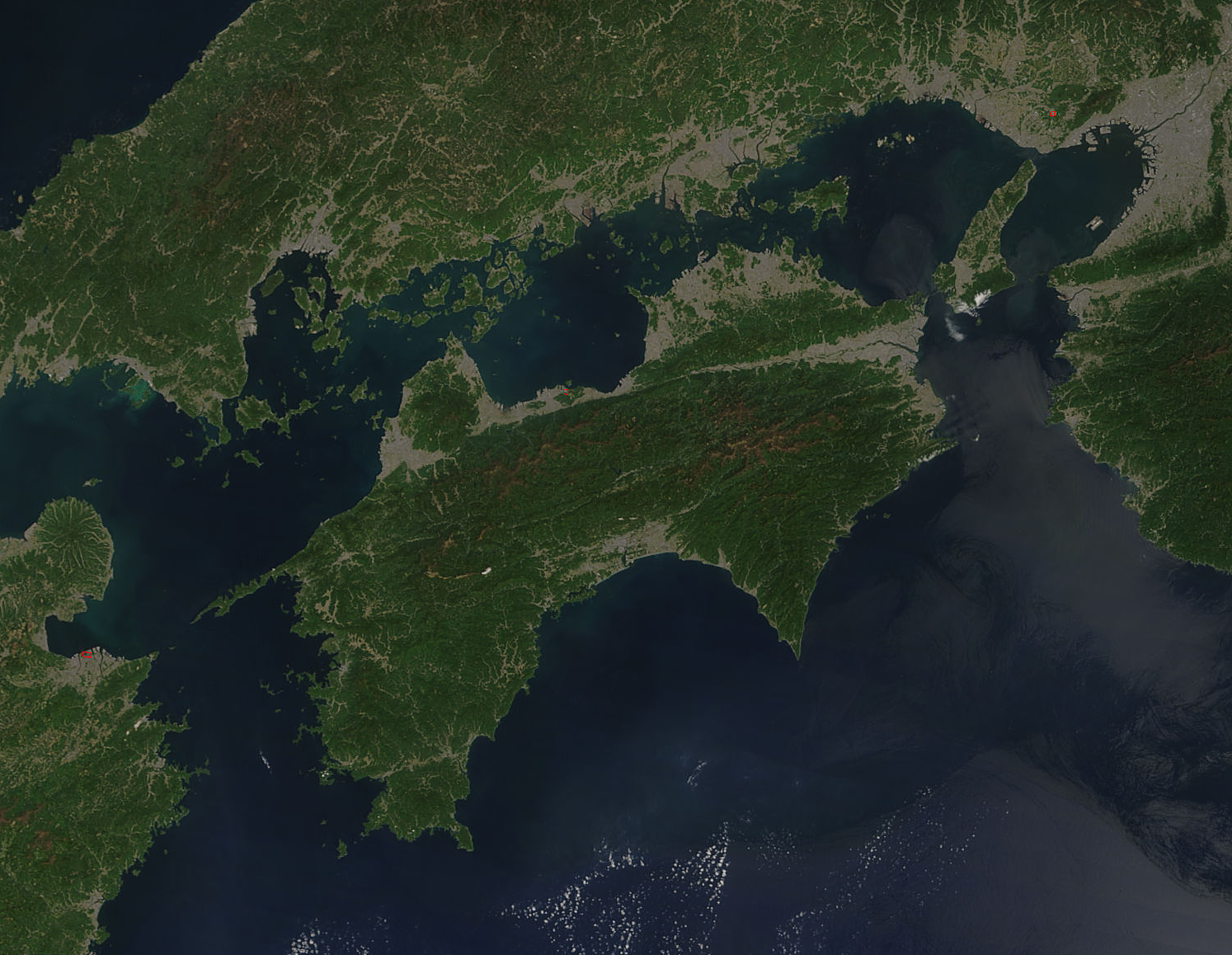
Shikoku (四国, Shikoku; pronounced [ɕi̥ꜜ.ko.kɯ, ɕi̥.koꜜ.kɯ] ⓘ, lit. 'four provinces') is the smallest of the four main islands of Japan. It is 225 kilometres (140 miles) long and between 50 and 150 kilometres (30 and 95 miles) wide. It has a population of 3.8 million, the least populated of Japan's four main islands. It is south of Honshu and northeast of Kyushu. Shikoku's ancient names include Iyo-no-futana-shima (伊予之二名島), Iyo-shima (伊予島), and Futana-shima (二名島), and its current name refers to the four former provinces that make up the island: Awa, Tosa, Sanuki, and Iyo.
Shikoku Island, comprising Shikoku and its surrounding islands, covers about 18,800 square kilometres (7,259 sq mi) and consists of four prefectures: Ehime, Kagawa, Kōchi, and Tokushima. Across the Seto Inland Sea lie Wakayama, Osaka, Hyōgo, Okayama, Hiroshima, and Yamaguchi Prefectures on Honshu. To the west lie Ōita and Miyazaki Prefectures on Kyushu.
Shikoku is ranked as the 50th largest island by area in the world. Additionally, it is ranked as the 23rd most populated island in the world, with a population density of 193 inhabitants per square kilometre (500/sq mi).
Mountains running east and west divide Shikoku into a narrow northern subregion, fronting on the Seto Inland Sea, and a southern part facing the Pacific Ocean. The Hydrangea hirta species can be found in these mountain ranges. Most of the 3.8 million inhabitants live in the north, and all but one of the island's few larger cities are located there. Mount Ishizuchi (石鎚山) in Ehime at 1,982 m (6,503 ft) is the highest mountain on the island. Industry is moderately well developed and includes the processing of ores from the important Besshi copper mine. Land is used intensively. Wide alluvial areas, especially in the eastern part of the zone, are planted with rice and subsequently are double-cropped with winter wheat and barley. Fruit is grown throughout the northern area in great variety, including citrus fruits, persimmons, peaches, and grapes. Because of wheat production, Sanuki udon (讃岐うどん) became an important part of the diet in Kagawa Prefecture (formerly Sanuki Province) in the Edo period.
The larger southern area of Shikoku is mountainous and sparsely populated. The only significant lowland is a small alluvial plain at Kōchi, the prefectural capital. The area's mild winters stimulated some truck farming, specializing in growing out-of-season vegetables under plastic covering. Two crops of rice can be cultivated annually in the southern area. The pulp and paper industry took advantage of the abundant forests and hydroelectric power.
The major river in Shikoku is the Yoshino River. It runs 196 km (121.8 mi) from its source close to Mount Ishizuchi, flowing basically west to east across the northern boundaries of Kōchi and Tokushima Prefectures, reaching the sea at the city of Tokushima. The Yoshino is famous for Japan's best white-water rafting, with trips going along the Oboke Koboke sections of the river.
Shikoku has four important capes: Gamōda in Anan, Tokushima on the easternmost point on the island, Sada in Ikata, Ehime on the westernmost point. Muroto in Muroto, Kōchi and Ashizuri, the southern extreme of Shikoku, in Tosashimizu, Kōchi, jut into the Pacific Ocean. The island's northernmost point is in Takamatsu.
Unlike the other three major islands of Japan, Shikoku has no active volcanoes, and is the largest of Japan's islands to completely lack them. But Shikoku did experience volcanic activity in the distant prehistoric past; a major volcanic caldera in the area of Mount Ishizuchi was active during the Miocene around 14 million years ago and the small volcanic cone of Mount Iino at an unknown date.
Hub AI
Shikoku AI simulator
(@Shikoku_simulator)
Shikoku
Shikoku (四国, Shikoku; pronounced [ɕi̥ꜜ.ko.kɯ, ɕi̥.koꜜ.kɯ] ⓘ, lit. 'four provinces') is the smallest of the four main islands of Japan. It is 225 kilometres (140 miles) long and between 50 and 150 kilometres (30 and 95 miles) wide. It has a population of 3.8 million, the least populated of Japan's four main islands. It is south of Honshu and northeast of Kyushu. Shikoku's ancient names include Iyo-no-futana-shima (伊予之二名島), Iyo-shima (伊予島), and Futana-shima (二名島), and its current name refers to the four former provinces that make up the island: Awa, Tosa, Sanuki, and Iyo.
Shikoku Island, comprising Shikoku and its surrounding islands, covers about 18,800 square kilometres (7,259 sq mi) and consists of four prefectures: Ehime, Kagawa, Kōchi, and Tokushima. Across the Seto Inland Sea lie Wakayama, Osaka, Hyōgo, Okayama, Hiroshima, and Yamaguchi Prefectures on Honshu. To the west lie Ōita and Miyazaki Prefectures on Kyushu.
Shikoku is ranked as the 50th largest island by area in the world. Additionally, it is ranked as the 23rd most populated island in the world, with a population density of 193 inhabitants per square kilometre (500/sq mi).
Mountains running east and west divide Shikoku into a narrow northern subregion, fronting on the Seto Inland Sea, and a southern part facing the Pacific Ocean. The Hydrangea hirta species can be found in these mountain ranges. Most of the 3.8 million inhabitants live in the north, and all but one of the island's few larger cities are located there. Mount Ishizuchi (石鎚山) in Ehime at 1,982 m (6,503 ft) is the highest mountain on the island. Industry is moderately well developed and includes the processing of ores from the important Besshi copper mine. Land is used intensively. Wide alluvial areas, especially in the eastern part of the zone, are planted with rice and subsequently are double-cropped with winter wheat and barley. Fruit is grown throughout the northern area in great variety, including citrus fruits, persimmons, peaches, and grapes. Because of wheat production, Sanuki udon (讃岐うどん) became an important part of the diet in Kagawa Prefecture (formerly Sanuki Province) in the Edo period.
The larger southern area of Shikoku is mountainous and sparsely populated. The only significant lowland is a small alluvial plain at Kōchi, the prefectural capital. The area's mild winters stimulated some truck farming, specializing in growing out-of-season vegetables under plastic covering. Two crops of rice can be cultivated annually in the southern area. The pulp and paper industry took advantage of the abundant forests and hydroelectric power.
The major river in Shikoku is the Yoshino River. It runs 196 km (121.8 mi) from its source close to Mount Ishizuchi, flowing basically west to east across the northern boundaries of Kōchi and Tokushima Prefectures, reaching the sea at the city of Tokushima. The Yoshino is famous for Japan's best white-water rafting, with trips going along the Oboke Koboke sections of the river.
Shikoku has four important capes: Gamōda in Anan, Tokushima on the easternmost point on the island, Sada in Ikata, Ehime on the westernmost point. Muroto in Muroto, Kōchi and Ashizuri, the southern extreme of Shikoku, in Tosashimizu, Kōchi, jut into the Pacific Ocean. The island's northernmost point is in Takamatsu.
Unlike the other three major islands of Japan, Shikoku has no active volcanoes, and is the largest of Japan's islands to completely lack them. But Shikoku did experience volcanic activity in the distant prehistoric past; a major volcanic caldera in the area of Mount Ishizuchi was active during the Miocene around 14 million years ago and the small volcanic cone of Mount Iino at an unknown date.
Recent media