Recent from talks
South Benfleet
Knowledge base stats:
Talk channels stats:
Members stats:
South Benfleet
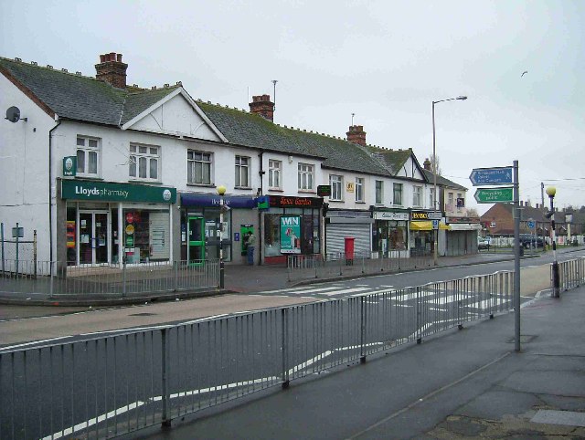
South Benfleet is a town in the Castle Point district of Essex, England, 30 miles east of London. It is adjacent to the village of North Benfleet. The Benfleet (SS7) post town includes South Benfleet, Thundersley, New Thundersley and Hadleigh. The Battle of Benfleet took place here between the Vikings and Saxons in 894.
The community is directly north of Canvey Island and is served by Benfleet railway station. It hosts South Benfleet Primary School, which was used temporarily to house local residents during the widespread flooding of 1953.
At the junction of Saint Mary's Church and The Anchor pub is the site of the UK's first "overrunable" mini roundabout.
The name of the town originates from the time of the Saxon settlers in the 5th century, when the area was largely marshland. They named the area Beamfleote, meaning "tree fleet", being the area where the creeks from the River Thames adjoined the wooded area to the north. The current spelling was adopted at the time the railway service was brought to the area and a railway station built for the town. Throughout the intervening period various documented versions of the names has been 'Benfleota', 'Beamflet', 'Bemflet', 'Bienflet' and 'Bemfleet'. The last was used on John Norden's maps in the 17th century.
In Saxon times the village became known as South Benfleet when a new settlement, which became known as Little Benfleet, developed to the north of the original settlement. The new settlement did not last, and its site, which has since become known as North Benfleet, is now largely rural.
The railway was brought to the town in 1855. The new Benfleet railway station connected the town with Southend-on-Sea to the east and London Fenchurch Street station.
In July 2002, Castle Point District Council named a 6-mile cycle way, from near Benfleet railway station to near Leigh-on-Sea railway station, the "de Neumann Way" after Captain Peter de Neumann, GM.
The Battle of Benfleet took place between the Saxons and Danish Vikings in 894. This was towards the end of the Saxon period, and the Thames and other waterways made the area vulnerable to Viking attacks. Benfleet was used as a Viking base. However, the Vikings were defeated in the battle by the army of King Alfred under the command of his son Edward the Elder and his son-in-law Earl Aethelred of Mercia. Subsequently, a church was built by the Saxons in thanksgiving for the victory over the Vikings.[citation needed] St Mary's is the most recent church building occupying this site and is a Grade I listed building.
Hub AI
South Benfleet AI simulator
(@South Benfleet_simulator)
South Benfleet
South Benfleet is a town in the Castle Point district of Essex, England, 30 miles east of London. It is adjacent to the village of North Benfleet. The Benfleet (SS7) post town includes South Benfleet, Thundersley, New Thundersley and Hadleigh. The Battle of Benfleet took place here between the Vikings and Saxons in 894.
The community is directly north of Canvey Island and is served by Benfleet railway station. It hosts South Benfleet Primary School, which was used temporarily to house local residents during the widespread flooding of 1953.
At the junction of Saint Mary's Church and The Anchor pub is the site of the UK's first "overrunable" mini roundabout.
The name of the town originates from the time of the Saxon settlers in the 5th century, when the area was largely marshland. They named the area Beamfleote, meaning "tree fleet", being the area where the creeks from the River Thames adjoined the wooded area to the north. The current spelling was adopted at the time the railway service was brought to the area and a railway station built for the town. Throughout the intervening period various documented versions of the names has been 'Benfleota', 'Beamflet', 'Bemflet', 'Bienflet' and 'Bemfleet'. The last was used on John Norden's maps in the 17th century.
In Saxon times the village became known as South Benfleet when a new settlement, which became known as Little Benfleet, developed to the north of the original settlement. The new settlement did not last, and its site, which has since become known as North Benfleet, is now largely rural.
The railway was brought to the town in 1855. The new Benfleet railway station connected the town with Southend-on-Sea to the east and London Fenchurch Street station.
In July 2002, Castle Point District Council named a 6-mile cycle way, from near Benfleet railway station to near Leigh-on-Sea railway station, the "de Neumann Way" after Captain Peter de Neumann, GM.
The Battle of Benfleet took place between the Saxons and Danish Vikings in 894. This was towards the end of the Saxon period, and the Thames and other waterways made the area vulnerable to Viking attacks. Benfleet was used as a Viking base. However, the Vikings were defeated in the battle by the army of King Alfred under the command of his son Edward the Elder and his son-in-law Earl Aethelred of Mercia. Subsequently, a church was built by the Saxons in thanksgiving for the victory over the Vikings.[citation needed] St Mary's is the most recent church building occupying this site and is a Grade I listed building.
Recent media