Recent from talks
Spherical coordinate system
Knowledge base stats:
Talk channels stats:
Members stats:
Spherical coordinate system
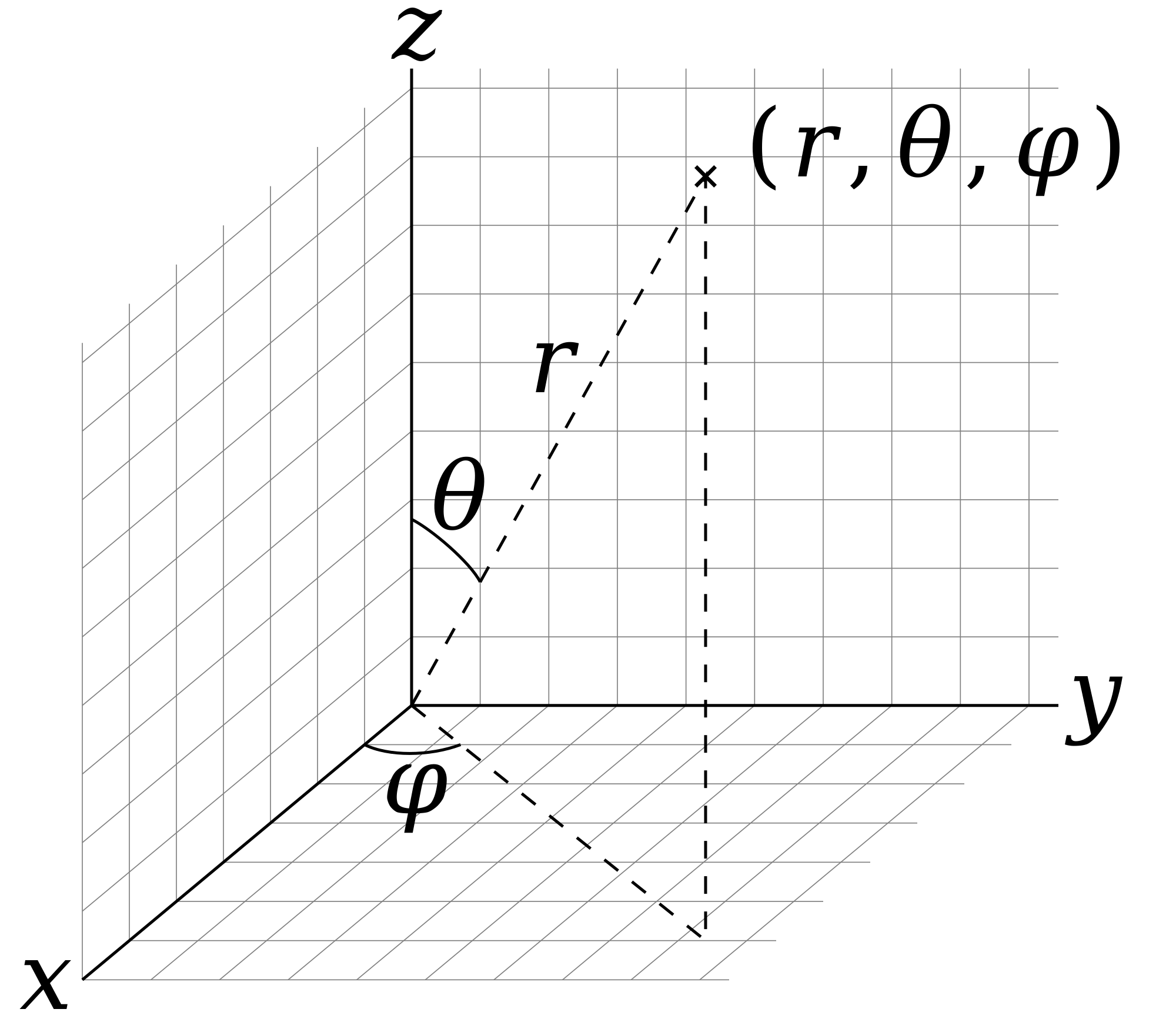
In mathematics, a spherical coordinate system specifies a given point in three-dimensional space by using a distance and two angles as its three coordinates. These are
(See graphic regarding the "physics convention".)
Once the radius is fixed, the three coordinates (r, θ, φ), known as a 3-tuple, provide a coordinate system on a sphere, typically called the spherical polar coordinates. The plane passing through the origin and perpendicular to the polar axis (where the polar angle is a right angle) is called the reference plane (sometimes fundamental plane).
The radial distance from the fixed point of origin is also called the radius, or radial line, or radial coordinate. The polar angle may be called inclination angle, zenith angle, normal angle, or the colatitude. The user may choose to replace the inclination angle by its complement, the elevation angle (or altitude angle), measured upward between the reference plane and the radial line—i.e., from the reference plane upward (towards to the positive z-axis) to the radial line. The depression angle is the negative of the elevation angle. (See graphic re the "physics convention"—not "mathematics convention".)
Both the use of symbols and the naming order of tuple coordinates differ among the several sources and disciplines. This article will use the ISO convention frequently encountered in physics, where the naming tuple gives the order as: radial distance, polar angle, azimuthal angle, or . (See graphic re the "physics convention".) In contrast, the conventions in many mathematics books and texts give the naming order differently as: radial distance, "azimuthal angle", "polar angle", and or —which switches the uses and meanings of symbols θ and φ. Other conventions may also be used, such as r for a radius from the z-axis that is not from the point of origin. Particular care must be taken to check the meaning of the symbols.


According to the conventions of geographical coordinate systems, positions are measured by latitude, longitude, and height (altitude). There are a number of celestial coordinate systems based on different fundamental planes and with different terms for the various coordinates. The spherical coordinate systems used in mathematics normally use radians rather than degrees; (note 90 degrees equals π⁄2 radians). And these systems of the mathematics convention may measure the azimuthal angle counterclockwise (i.e., from the south direction x-axis, or 180°, towards the east direction y-axis, or +90°)—rather than measure clockwise (i.e., from the north direction x-axis, or 0°, towards the east direction y-axis, or +90°), as done in the horizontal coordinate system. (See graphic re "mathematics convention".)
The spherical coordinate system of the physics convention can be seen as a generalization of the polar coordinate system in three-dimensional space. It can be further extended to higher-dimensional spaces, and is then referred to as a hyperspherical coordinate system.
To define a spherical coordinate system, one must designate an origin point in space, O, and two orthogonal directions: the zenith reference direction and the azimuth reference direction. These choices determine a reference plane that is typically defined as containing the point of origin and the x– and y–axes, either of which may be designated as the azimuth reference direction. The reference plane is perpendicular (orthogonal) to the zenith direction, and typically is designated "horizontal" to the zenith direction's "vertical". The spherical coordinates of a point P then are defined as follows:
Hub AI
Spherical coordinate system AI simulator
(@Spherical coordinate system_simulator)
Spherical coordinate system
In mathematics, a spherical coordinate system specifies a given point in three-dimensional space by using a distance and two angles as its three coordinates. These are
(See graphic regarding the "physics convention".)
Once the radius is fixed, the three coordinates (r, θ, φ), known as a 3-tuple, provide a coordinate system on a sphere, typically called the spherical polar coordinates. The plane passing through the origin and perpendicular to the polar axis (where the polar angle is a right angle) is called the reference plane (sometimes fundamental plane).
The radial distance from the fixed point of origin is also called the radius, or radial line, or radial coordinate. The polar angle may be called inclination angle, zenith angle, normal angle, or the colatitude. The user may choose to replace the inclination angle by its complement, the elevation angle (or altitude angle), measured upward between the reference plane and the radial line—i.e., from the reference plane upward (towards to the positive z-axis) to the radial line. The depression angle is the negative of the elevation angle. (See graphic re the "physics convention"—not "mathematics convention".)
Both the use of symbols and the naming order of tuple coordinates differ among the several sources and disciplines. This article will use the ISO convention frequently encountered in physics, where the naming tuple gives the order as: radial distance, polar angle, azimuthal angle, or . (See graphic re the "physics convention".) In contrast, the conventions in many mathematics books and texts give the naming order differently as: radial distance, "azimuthal angle", "polar angle", and or —which switches the uses and meanings of symbols θ and φ. Other conventions may also be used, such as r for a radius from the z-axis that is not from the point of origin. Particular care must be taken to check the meaning of the symbols.
According to the conventions of geographical coordinate systems, positions are measured by latitude, longitude, and height (altitude). There are a number of celestial coordinate systems based on different fundamental planes and with different terms for the various coordinates. The spherical coordinate systems used in mathematics normally use radians rather than degrees; (note 90 degrees equals π⁄2 radians). And these systems of the mathematics convention may measure the azimuthal angle counterclockwise (i.e., from the south direction x-axis, or 180°, towards the east direction y-axis, or +90°)—rather than measure clockwise (i.e., from the north direction x-axis, or 0°, towards the east direction y-axis, or +90°), as done in the horizontal coordinate system. (See graphic re "mathematics convention".)
The spherical coordinate system of the physics convention can be seen as a generalization of the polar coordinate system in three-dimensional space. It can be further extended to higher-dimensional spaces, and is then referred to as a hyperspherical coordinate system.
To define a spherical coordinate system, one must designate an origin point in space, O, and two orthogonal directions: the zenith reference direction and the azimuth reference direction. These choices determine a reference plane that is typically defined as containing the point of origin and the x– and y–axes, either of which may be designated as the azimuth reference direction. The reference plane is perpendicular (orthogonal) to the zenith direction, and typically is designated "horizontal" to the zenith direction's "vertical". The spherical coordinates of a point P then are defined as follows:
Recent media