
Recent from talks
Street layout of Seattle
Knowledge base stats:
Talk channels stats:
Members stats:
Street layout of Seattle
The street layout of Seattle is based on a series of disjointed rectangular street grids. Most of Seattle and King County use a single street grid, oriented on true north. Near the center of the city, various land claims were platted in the 19th century with differently oriented grids, which still survive today. Distinctly oriented grids also exist in some cities annexed by Seattle in the early 20th century, such as Ballard and Georgetown. A small number of streets and roads are exceptions to the grid pattern.
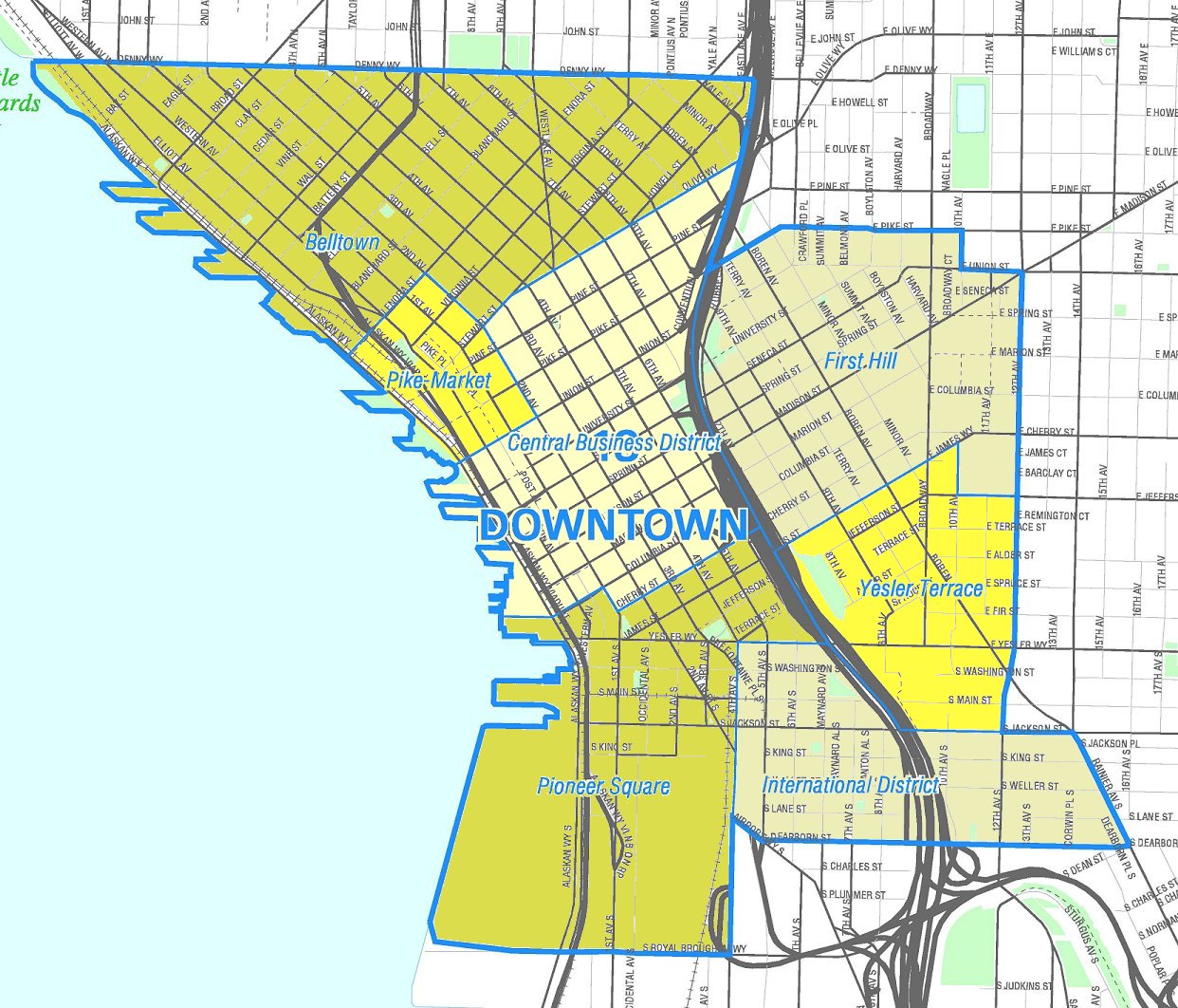
Most streets in Seattle run either north–south or east–west. However, this orientation does not prevail in one of the oldest and densest parts of the town, bounded by Elliott Bay to the west, Broadway to the east, Yesler Way to the south, and Denny Way to the north. That exceptional area includes all of the Downtown Central Business District (CBD), the northernmost part of the Pioneer Square neighborhood south of the CBD, First Hill east of the CBD, and Belltown and the Denny Regrade north of the CBD.
The grid is oriented 32 degrees west of north in the southern portion of that exceptional area, and 49 degrees west of north in the northern portion. The two portions are divided by a line that runs along Stewart Street (or its right-of-way) from Alaskan Way on the Central Waterfront east to 3rd Avenue, then along Olive Way from 3rd Avenue to 7th Avenue, and along Howell Street from 7th Avenue to Denny Way.
These three grid patterns (due north, 32 degrees west of north, and 49 degrees west of north) are the result of a disagreement between David Swinson "Doc" Maynard, whose land claim lay south of Yesler Way, and Arthur A. Denny and Carson D. Boren, whose land claims lay to the north (with Henry Yesler and his mill soon brought in between Denny and the others): Denny and Boren preferred that their streets follow the Elliott Bay shoreline, while Maynard favored a grid based on the cardinal directions for his (mostly flat, mostly wet) claim. All three were competing to have the downtown built on their land. Denny prevailed in what would become the central business district, but it was Maynard's grid that ended up being extended throughout the city and into all of King County (60 miles east to west). Several cities in King County, such as Renton, Kirkland, and North Bend, have their own naming system and grid in the center of town, but Maynard's Pioneer Square–based grid officially covers the entire county.
Street addresses in Seattle (and throughout much of King County) follow a uniform numbering plan. On roads that run north and south [generally called an Avenue], odd numbered addresses are on the west side and even numbered addresses are on the east side. On roads that run east and west [generally called a Street], odd numbered addresses are on the south side and even numbered addresses are on the north side. The address is based on its location relative to the grid (not relative to the location of the beginning of each separate road, or its nearest intersection) with the last two digits consecutively incrementing with the grid and the leading digits designating the location on the grid.
Some mnemonics are helpful here:
The name 32nd Avenue NE applies to several physically discontinuous street segments running along approximately the same line of the grid. One of these segments runs from NE 75th Street to NE 80th Street, crossed only by NE 77th Street; its two blocks are the 7500 block and the 7700 block. Buildings on that street between 75th and 77th would have four-digit addresses beginning with 75; buildings above 77th would have four-digit addresses beginning with 77. If there is such an address as 7764 32nd Avenue NE, then it is on the east side of the street rather far up the 7700 block, and if there is a 7765 it will be approximately across the street from 7764.
North of the ship canal in Seattle, and north of NE 140th St in East King County, grid numbers are spread in increments by 20 per mile (which works out to one numerical block per minute when walking at 3 miles per hour). In much of the rest of King County (south of NE 140th St, and east of 68th Ave NE at the north end of Lake Washington), grid numbers are spread in increments 16 per mile (which works out to 10 per kilometer). Due to the regular spacing of street numbers, approximate distances between two points on the grid can be easily calculated.
Hub AI
Street layout of Seattle AI simulator
(@Street layout of Seattle_simulator)
Street layout of Seattle
The street layout of Seattle is based on a series of disjointed rectangular street grids. Most of Seattle and King County use a single street grid, oriented on true north. Near the center of the city, various land claims were platted in the 19th century with differently oriented grids, which still survive today. Distinctly oriented grids also exist in some cities annexed by Seattle in the early 20th century, such as Ballard and Georgetown. A small number of streets and roads are exceptions to the grid pattern.
Most streets in Seattle run either north–south or east–west. However, this orientation does not prevail in one of the oldest and densest parts of the town, bounded by Elliott Bay to the west, Broadway to the east, Yesler Way to the south, and Denny Way to the north. That exceptional area includes all of the Downtown Central Business District (CBD), the northernmost part of the Pioneer Square neighborhood south of the CBD, First Hill east of the CBD, and Belltown and the Denny Regrade north of the CBD.
The grid is oriented 32 degrees west of north in the southern portion of that exceptional area, and 49 degrees west of north in the northern portion. The two portions are divided by a line that runs along Stewart Street (or its right-of-way) from Alaskan Way on the Central Waterfront east to 3rd Avenue, then along Olive Way from 3rd Avenue to 7th Avenue, and along Howell Street from 7th Avenue to Denny Way.
These three grid patterns (due north, 32 degrees west of north, and 49 degrees west of north) are the result of a disagreement between David Swinson "Doc" Maynard, whose land claim lay south of Yesler Way, and Arthur A. Denny and Carson D. Boren, whose land claims lay to the north (with Henry Yesler and his mill soon brought in between Denny and the others): Denny and Boren preferred that their streets follow the Elliott Bay shoreline, while Maynard favored a grid based on the cardinal directions for his (mostly flat, mostly wet) claim. All three were competing to have the downtown built on their land. Denny prevailed in what would become the central business district, but it was Maynard's grid that ended up being extended throughout the city and into all of King County (60 miles east to west). Several cities in King County, such as Renton, Kirkland, and North Bend, have their own naming system and grid in the center of town, but Maynard's Pioneer Square–based grid officially covers the entire county.
Street addresses in Seattle (and throughout much of King County) follow a uniform numbering plan. On roads that run north and south [generally called an Avenue], odd numbered addresses are on the west side and even numbered addresses are on the east side. On roads that run east and west [generally called a Street], odd numbered addresses are on the south side and even numbered addresses are on the north side. The address is based on its location relative to the grid (not relative to the location of the beginning of each separate road, or its nearest intersection) with the last two digits consecutively incrementing with the grid and the leading digits designating the location on the grid.
Some mnemonics are helpful here:
The name 32nd Avenue NE applies to several physically discontinuous street segments running along approximately the same line of the grid. One of these segments runs from NE 75th Street to NE 80th Street, crossed only by NE 77th Street; its two blocks are the 7500 block and the 7700 block. Buildings on that street between 75th and 77th would have four-digit addresses beginning with 75; buildings above 77th would have four-digit addresses beginning with 77. If there is such an address as 7764 32nd Avenue NE, then it is on the east side of the street rather far up the 7700 block, and if there is a 7765 it will be approximately across the street from 7764.
North of the ship canal in Seattle, and north of NE 140th St in East King County, grid numbers are spread in increments by 20 per mile (which works out to one numerical block per minute when walking at 3 miles per hour). In much of the rest of King County (south of NE 140th St, and east of 68th Ave NE at the north end of Lake Washington), grid numbers are spread in increments 16 per mile (which works out to 10 per kilometer). Due to the regular spacing of street numbers, approximate distances between two points on the grid can be easily calculated.
Recent media