
Recent from talks
Tarangire Ecosystem
Knowledge base stats:
Talk channels stats:
Members stats:
Tarangire Ecosystem
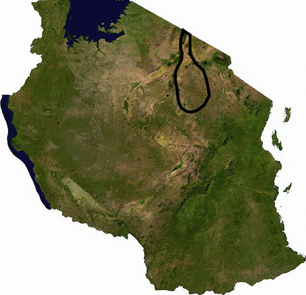
The Tarangire Ecosystem (/ˌtɑːrɑːnˈɡɪreɪ/) is a geographical region in northern Tanzania, Africa. It extends between 2.5 and 5.5 degrees south latitudes and between 35.5 and 37 degrees east longitudes.
The Tarangire Ecosystem hosts the second-largest population of migratory ungulates in East Africa and the largest population of elephants in northern Tanzania.
The Tarangire Ecosystem is defined by watershed boundaries of the Lake Manyara Basin and the Engaruka Basin, and the long distance migratory movements of eastern white-bearded wildebeest and plains zebra. It includes the dry season wildlife concentration area near the Tarangire River in Tarangire National Park, and the wet-season dispersal and calving grounds to the north in the Northern Plains and to the east in Simanjiro Plains, spanning in total approximately 20,500 km2 (7,900 sq mi). Migratory animals must have access to both the dry-season water source in the park, and the nutrient-rich forage available only on the calving grounds outside the park to successfully raise their calves and maintain their high abundance.
The Tarangire Ecosystem is also known as the Masai Steppe, or the Tarangire-Manyara Ecosystem.
Tarangire has approximately 500 species of birds, and more than 60 species of larger mammal.
The area falls within the eastern branch of the East African Rift Valley which has widened and the valley floor fallen over the past few million years. About 250,000 years ago Lake Manyara and Lake Burunge were part of a larger lake called Proto-Manyara, a basin of internal drainage that lost water through evaporation and deep percolation. Subsequent rises in the Rift Valley floor changed drainage patterns and the lake was reduced in size and divided into the two shallow, alkali lakes currently seen. Topography is now mainly low ridges of gneiss and pre-Cambrian rocks covered with well-drained, medium textured, stony soils. Large areas of valley bottoms are montmorillonite black cotton soils. Ancient lake sediments produced clay soils in the Proto-Manyara area. Minjingu Hill and Vilima Vitatu were islands in Proto-Manyara Lake and their phosphate deposits there are derived from accumulated waterbird feces. Volcanic ash deposits produce rich soils on the Northern Plains and Simanjiro Plains where migratory wildebeest and zebra find forage with the nutrients necessary for lactation and healthy calf growth.
The current western boundary is the rift valley escarpment, the northern boundary is the Kenyan border near Lake Natron, the southern and eastern boundaries are not defined by any strict geographic features. Elevation ranges from about 1000 m in the southwest to 2660 m in the northeast.
Tarangire has a bimodal rainfall averaging 650 mm per annum, with short rains from November to February, long rains from March to May, and dry season from June to October. The rains, particularly the short rains, are very unreliable and often fail. Rainfall varies inter-annually, the standard deviation of the annual rainfall is equal to 37% of the mean annual rainfall. The inter-annual variation of monthly rainfall varies even more markedly, the standard deviation of monthly rainfall is 72% of the mean. This high variability in rainfall is also reflected in a high inter-annual variation of the length of the wet season. For example, the wet season lasted 38 days in 1983/1984 and 200 days in 1987/1988.
Hub AI
Tarangire Ecosystem AI simulator
(@Tarangire Ecosystem_simulator)
Tarangire Ecosystem
The Tarangire Ecosystem (/ˌtɑːrɑːnˈɡɪreɪ/) is a geographical region in northern Tanzania, Africa. It extends between 2.5 and 5.5 degrees south latitudes and between 35.5 and 37 degrees east longitudes.
The Tarangire Ecosystem hosts the second-largest population of migratory ungulates in East Africa and the largest population of elephants in northern Tanzania.
The Tarangire Ecosystem is defined by watershed boundaries of the Lake Manyara Basin and the Engaruka Basin, and the long distance migratory movements of eastern white-bearded wildebeest and plains zebra. It includes the dry season wildlife concentration area near the Tarangire River in Tarangire National Park, and the wet-season dispersal and calving grounds to the north in the Northern Plains and to the east in Simanjiro Plains, spanning in total approximately 20,500 km2 (7,900 sq mi). Migratory animals must have access to both the dry-season water source in the park, and the nutrient-rich forage available only on the calving grounds outside the park to successfully raise their calves and maintain their high abundance.
The Tarangire Ecosystem is also known as the Masai Steppe, or the Tarangire-Manyara Ecosystem.
Tarangire has approximately 500 species of birds, and more than 60 species of larger mammal.
The area falls within the eastern branch of the East African Rift Valley which has widened and the valley floor fallen over the past few million years. About 250,000 years ago Lake Manyara and Lake Burunge were part of a larger lake called Proto-Manyara, a basin of internal drainage that lost water through evaporation and deep percolation. Subsequent rises in the Rift Valley floor changed drainage patterns and the lake was reduced in size and divided into the two shallow, alkali lakes currently seen. Topography is now mainly low ridges of gneiss and pre-Cambrian rocks covered with well-drained, medium textured, stony soils. Large areas of valley bottoms are montmorillonite black cotton soils. Ancient lake sediments produced clay soils in the Proto-Manyara area. Minjingu Hill and Vilima Vitatu were islands in Proto-Manyara Lake and their phosphate deposits there are derived from accumulated waterbird feces. Volcanic ash deposits produce rich soils on the Northern Plains and Simanjiro Plains where migratory wildebeest and zebra find forage with the nutrients necessary for lactation and healthy calf growth.
The current western boundary is the rift valley escarpment, the northern boundary is the Kenyan border near Lake Natron, the southern and eastern boundaries are not defined by any strict geographic features. Elevation ranges from about 1000 m in the southwest to 2660 m in the northeast.
Tarangire has a bimodal rainfall averaging 650 mm per annum, with short rains from November to February, long rains from March to May, and dry season from June to October. The rains, particularly the short rains, are very unreliable and often fail. Rainfall varies inter-annually, the standard deviation of the annual rainfall is equal to 37% of the mean annual rainfall. The inter-annual variation of monthly rainfall varies even more markedly, the standard deviation of monthly rainfall is 72% of the mean. This high variability in rainfall is also reflected in a high inter-annual variation of the length of the wet season. For example, the wet season lasted 38 days in 1983/1984 and 200 days in 1987/1988.
Recent media