
Recent from talks
Thai Canal
Knowledge base stats:
Talk channels stats:
Members stats:
Thai Canal
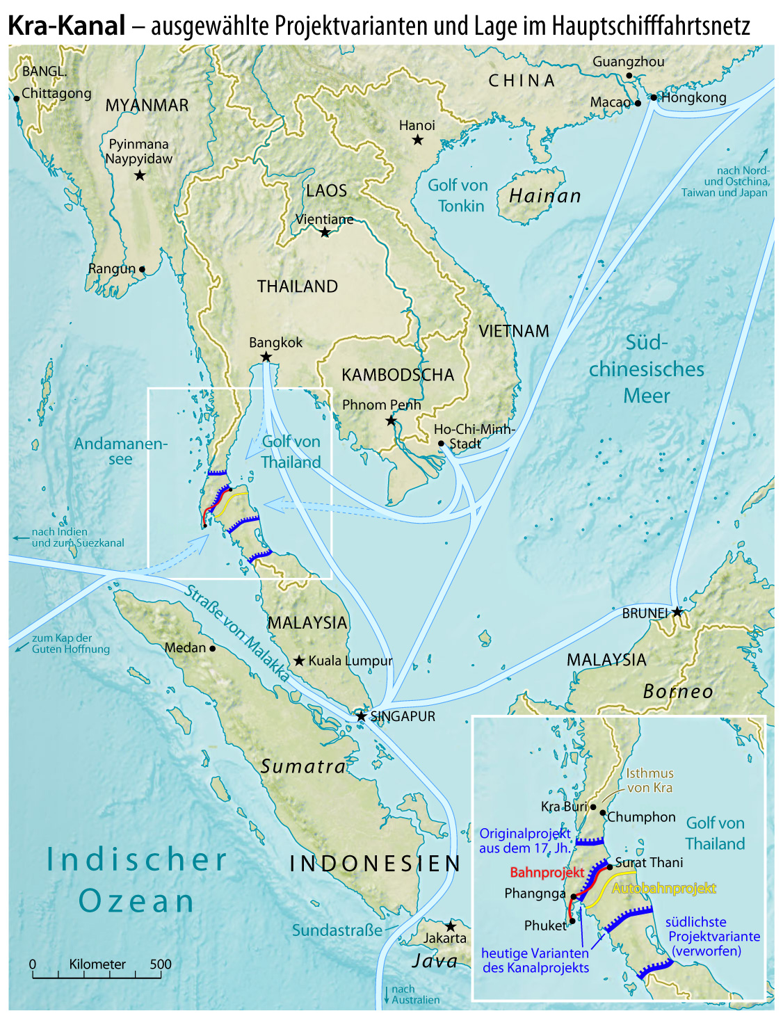
The Thai Canal (Thai: คลองไทย), also known as the Kra Canal (คลองกระ) or the Kra Isthmus Canal (คลองคอคอดกระ), is any of several proposals for a canal that would connect the Gulf of Thailand with the Andaman Sea across the Kra Isthmus in southern Thailand. Such a canal is suggested to significantly reduce travel times through heavily-navigated trade routes.
The canal would provide an alternative to transit through the Strait of Malacca and shorten transit for shipments of oil to Japan and China by 1,200 km. China refers to it as part of its 21st century maritime Silk Road. Proposals, as of 2015,[update] measure 102 kilometres long, 400 meters wide and 25 meters deep. Plans for a canal have been discussed and explored at various times. Cost, environmental concerns, and geopolitical concerns have been weighed against the potential economic and strategic benefits.
In February 2018, Thailand's Prime Minister Prayut Chan-o-cha declared that the canal was not a government priority.
A canal through the Kra Isthmus, which would shorten shipping times around Asia, was suggested as early as 1677. Thai King Narai asked the French engineer de Lamar to survey the possibility of building a waterway to connect Songkhla with Marid (now Myanmar), but the idea was discarded as impractical with the technology of that time.
In 1793, the idea resurfaced. Maha Sura Singhanat, the younger brother of King Chakri (Rama I), suggested it would make it easier to protect the west coast with military ships. In the early-19th century, the British East India Company became interested in a canal. After Burma became a British colony in 1863, an exploration was undertaken with Victoria Point (Kawthaung) opposite the Kra estuary as its southernmost point, again with negative result. In 1882, the constructor of the Suez canal, Ferdinand de Lesseps, visited the area, but the Thai king did not allow him to investigate in detail. In 1897, Thailand and the British empire agreed not to build a canal so that the regional dominance of the harbour of Singapore would be maintained.
In 1946, Thailand and the United Kingdom signed the Anglo-Thai Peace Treaty, ending the state of war between the two countries during the Second World War. Out of the many concessions made in the treaty, one of the articles forbid the Thais from digging a canal across the Kra isthmus without British government permission.
As there was no progress on a canal, the construction of a road for cargo across the isthmus was started in 1993. Such a large highway was built, but because the location of the harbours was not set, Highway 44 does not yet end at the sea. Its sets of lanes are 150 m apart to leave space for railway and a pipeline. As of 2020[update], the highway runs from 8°18.11′N 98°47.03′E / 8.30183°N 98.78383°E to 9°9.47′N 99°31.02′E / 9.15783°N 99.51700°E.
The width of the Kra Isthmus at its minimum is only 44 km (27 mi), but the height of the intervening hills is 75 m (246 ft). The Panama Canal has a length of 77 km (48 mi), but highest point at the Culebra Cut was only 64 m (210 ft). The Panama Canal passes this point at a height of 12 m (39 ft) (canal bottom) and 26 m (85 ft) (water line), thus ships have to be lifted with locks to a height of 26 m (85 ft) above the ocean. The Suez Canal is 192 km (119 mi) long but passes entirely through a flat area (which was historically flooded by seas). At a depth of 25 m (82 ft) below sea level the width of the Kra Isthmus is about 200 km (120 mi).[failed verification] At 50 m (160 ft) below sea level this becomes about 400 km (250 mi).[failed verification]
Hub AI
Thai Canal AI simulator
(@Thai Canal_simulator)
Thai Canal
The Thai Canal (Thai: คลองไทย), also known as the Kra Canal (คลองกระ) or the Kra Isthmus Canal (คลองคอคอดกระ), is any of several proposals for a canal that would connect the Gulf of Thailand with the Andaman Sea across the Kra Isthmus in southern Thailand. Such a canal is suggested to significantly reduce travel times through heavily-navigated trade routes.
The canal would provide an alternative to transit through the Strait of Malacca and shorten transit for shipments of oil to Japan and China by 1,200 km. China refers to it as part of its 21st century maritime Silk Road. Proposals, as of 2015,[update] measure 102 kilometres long, 400 meters wide and 25 meters deep. Plans for a canal have been discussed and explored at various times. Cost, environmental concerns, and geopolitical concerns have been weighed against the potential economic and strategic benefits.
In February 2018, Thailand's Prime Minister Prayut Chan-o-cha declared that the canal was not a government priority.
A canal through the Kra Isthmus, which would shorten shipping times around Asia, was suggested as early as 1677. Thai King Narai asked the French engineer de Lamar to survey the possibility of building a waterway to connect Songkhla with Marid (now Myanmar), but the idea was discarded as impractical with the technology of that time.
In 1793, the idea resurfaced. Maha Sura Singhanat, the younger brother of King Chakri (Rama I), suggested it would make it easier to protect the west coast with military ships. In the early-19th century, the British East India Company became interested in a canal. After Burma became a British colony in 1863, an exploration was undertaken with Victoria Point (Kawthaung) opposite the Kra estuary as its southernmost point, again with negative result. In 1882, the constructor of the Suez canal, Ferdinand de Lesseps, visited the area, but the Thai king did not allow him to investigate in detail. In 1897, Thailand and the British empire agreed not to build a canal so that the regional dominance of the harbour of Singapore would be maintained.
In 1946, Thailand and the United Kingdom signed the Anglo-Thai Peace Treaty, ending the state of war between the two countries during the Second World War. Out of the many concessions made in the treaty, one of the articles forbid the Thais from digging a canal across the Kra isthmus without British government permission.
As there was no progress on a canal, the construction of a road for cargo across the isthmus was started in 1993. Such a large highway was built, but because the location of the harbours was not set, Highway 44 does not yet end at the sea. Its sets of lanes are 150 m apart to leave space for railway and a pipeline. As of 2020[update], the highway runs from 8°18.11′N 98°47.03′E / 8.30183°N 98.78383°E to 9°9.47′N 99°31.02′E / 9.15783°N 99.51700°E.
The width of the Kra Isthmus at its minimum is only 44 km (27 mi), but the height of the intervening hills is 75 m (246 ft). The Panama Canal has a length of 77 km (48 mi), but highest point at the Culebra Cut was only 64 m (210 ft). The Panama Canal passes this point at a height of 12 m (39 ft) (canal bottom) and 26 m (85 ft) (water line), thus ships have to be lifted with locks to a height of 26 m (85 ft) above the ocean. The Suez Canal is 192 km (119 mi) long but passes entirely through a flat area (which was historically flooded by seas). At a depth of 25 m (82 ft) below sea level the width of the Kra Isthmus is about 200 km (120 mi).[failed verification] At 50 m (160 ft) below sea level this becomes about 400 km (250 mi).[failed verification]
Recent media