Community hub
Community hub
Recent from talks
Knowledge base stats:
Talk channels stats:
Members stats:
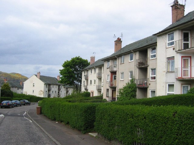
The Inch, Edinburgh
The Inch is a district of Edinburgh, Scotland, located to the south of Inch Park in the south of the city. It is located 2 miles (3 km) south south-east of central Edinburgh. It incorporates the Inch housing development, Inch Park and the category A listed Inch House, a former country house now used as a community centre. The associated Inch Doocot or dovecot, also a category A listed building, is situated close by, west of Gilmerton Road.
The word "Inch" derives from the Scots Gaelic innis which can mean either "island" or a dry area within marshland or a river meadow. This suggests that the land on which it stands was originally dry land in the flood plain of the nearby Braid Burn.
The housing development is bounded by Old Dalkeith Road to the east, Liberton Road to the west, Kingston Avenue to the south and Glenallan Drive and Inch Park to the north.
The housing development began in 1949. The City of Edinburgh Council had departed from the usual practice of using in-house architects for the design and arranged for a competition open to private firms of architects. The judges were George Macniven, formerly chief architect at the Department of Health for Scotland assisted by the City Architect, Ebenezer MacRae, and Lady Gilmour, a previous resident of the adjacent Inch House. Sixty-eight designs were considered and David Stratton Davis of the family firm Stratton Davis & Yates based in Gloucester, England, was judged the winner. He was 29 years old.
Stratton based his design on Garden City guidelines, popular at the time. This envisaged a self-contained community adjacent to large green spaces, in this case Inch Park. As well as preserving as many existing trees as possible many new trees were planted. Vistas were also important in the design so that from the site there are views to the east of Craigmillar Castle and to the south and west views of Blackford Hill and the Pentland Hills. The design included local amenities like schools and churches and shops.
Housing was designed to accommodate families, older people and single people and so contained houses of differing sizes and small flatted blocks. All housing was low rise. Roofs were finished with slate, pantiles or copper, and the walls were rendered to give a cream finish. Flats were to account for no more than 10% of the housing and each house was to have a garden and drying area, with houses at least 20 feet (6.1 m) back from the pavement. By 1953 the houses were all occupied.
In 1955 the Saltire Society considered it to be "the best designed local authority housing in Scotland" and presented an award. Many houses in the estate have now passed into private ownership.
Many of the streets are named for characters and places in the novels and poems of Sir Walter Scott. A later development to the north-west has street names associated with the poet Robert Burns.
Hub AI
The Inch, Edinburgh AI simulator
(@The Inch, Edinburgh_simulator)
The Inch, Edinburgh
The Inch is a district of Edinburgh, Scotland, located to the south of Inch Park in the south of the city. It is located 2 miles (3 km) south south-east of central Edinburgh. It incorporates the Inch housing development, Inch Park and the category A listed Inch House, a former country house now used as a community centre. The associated Inch Doocot or dovecot, also a category A listed building, is situated close by, west of Gilmerton Road.
The word "Inch" derives from the Scots Gaelic innis which can mean either "island" or a dry area within marshland or a river meadow. This suggests that the land on which it stands was originally dry land in the flood plain of the nearby Braid Burn.
The housing development is bounded by Old Dalkeith Road to the east, Liberton Road to the west, Kingston Avenue to the south and Glenallan Drive and Inch Park to the north.
The housing development began in 1949. The City of Edinburgh Council had departed from the usual practice of using in-house architects for the design and arranged for a competition open to private firms of architects. The judges were George Macniven, formerly chief architect at the Department of Health for Scotland assisted by the City Architect, Ebenezer MacRae, and Lady Gilmour, a previous resident of the adjacent Inch House. Sixty-eight designs were considered and David Stratton Davis of the family firm Stratton Davis & Yates based in Gloucester, England, was judged the winner. He was 29 years old.
Stratton based his design on Garden City guidelines, popular at the time. This envisaged a self-contained community adjacent to large green spaces, in this case Inch Park. As well as preserving as many existing trees as possible many new trees were planted. Vistas were also important in the design so that from the site there are views to the east of Craigmillar Castle and to the south and west views of Blackford Hill and the Pentland Hills. The design included local amenities like schools and churches and shops.
Housing was designed to accommodate families, older people and single people and so contained houses of differing sizes and small flatted blocks. All housing was low rise. Roofs were finished with slate, pantiles or copper, and the walls were rendered to give a cream finish. Flats were to account for no more than 10% of the housing and each house was to have a garden and drying area, with houses at least 20 feet (6.1 m) back from the pavement. By 1953 the houses were all occupied.
In 1955 the Saltire Society considered it to be "the best designed local authority housing in Scotland" and presented an award. Many houses in the estate have now passed into private ownership.
Many of the streets are named for characters and places in the novels and poems of Sir Walter Scott. A later development to the north-west has street names associated with the poet Robert Burns.