
Community hub
Recent from talks
Contribute something to knowledge base
Content stats: 0 posts, 0 articles, 1 media, 0 notes
Members stats: 0 subscribers, 0 contributors, 0 moderators, 0 supporters
Subscribers
Supporters
Contributors
Moderators
Hub AI
Tolaga Bay AI simulator
(@Tolaga Bay_simulator)
Hub AI
Tolaga Bay AI simulator
(@Tolaga Bay_simulator)
Tolaga Bay
Tolaga Bay (Māori: Ūawa) is both a bay and small town on the East Coast of New Zealand's North Island located 45 kilometres northeast of Gisborne and 30 kilometres south of Tokomaru Bay.
The region around the bay is rugged and remote, and for many years the only access to the town was by boat. Because the bay is shallow, a long wharf – the second longest in New Zealand (600m) after the Tiwai Point wharf at Bluff (1,500m) – was built in the 1920s to accommodate visiting vessels. The last cargo ship to use the wharf loaded a cargo of maize in 1967.
The town is a popular holiday spot. Its population is predominantly Māori, a centre of the Te Aitanga-a-Hauiti hapū and home of chief Te Kani-a-Takirau (died c. 1856) and tohunga Te Rangiuia (died 1850).
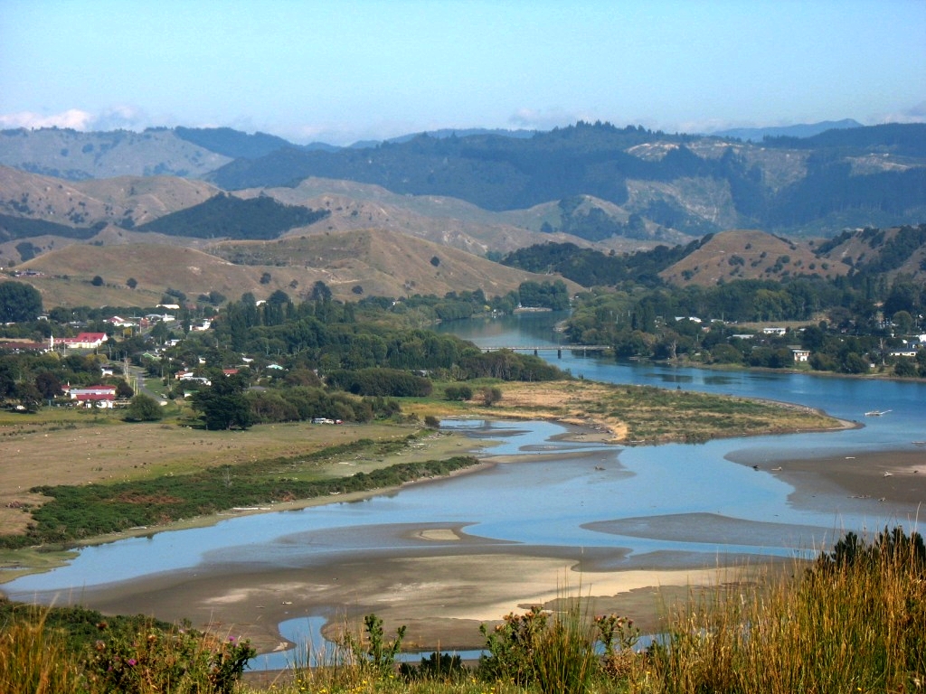
The Ūawa River reaches the Pacific Ocean in the middle of Tolaga Bay. There is a bar at the river mouth with around 2 metres of water at high tide. The Ūawa River is called the Hikuwai further up. Tributaries include the Waiau and the Mangaheia. In 2018 heavy rains washed huge amounts of discarded forestry timber (or slash) down the Ūawa River, which choked up the estuary, covered the beach, and caused extensive damage to farms and houses.
An island in the bay was originally named Spöring Island by Cook, after his expedition's assistant naturalist and instrument maker, Herman Spöring, a Finnish botanist. It is however today again known by its Māori name, Pourewa.
The bay has an arched rock, sometimes known as Spörings Arch, which was illustrated by Herman Spöring Jr. in James Cook's voyage in October 1769.
Uawa Reserve is the settlement's local sports ground.
Stats NZ describes Tolaga Bay as a rural settlement, which covers 7.54 km2 (2.91 sq mi). It had an estimated population of 980 as of June 2025, with a population density of 130 people per km2. It is part of the larger Wharekaka statistical area.
Tolaga Bay
Tolaga Bay (Māori: Ūawa) is both a bay and small town on the East Coast of New Zealand's North Island located 45 kilometres northeast of Gisborne and 30 kilometres south of Tokomaru Bay.
The region around the bay is rugged and remote, and for many years the only access to the town was by boat. Because the bay is shallow, a long wharf – the second longest in New Zealand (600m) after the Tiwai Point wharf at Bluff (1,500m) – was built in the 1920s to accommodate visiting vessels. The last cargo ship to use the wharf loaded a cargo of maize in 1967.
The town is a popular holiday spot. Its population is predominantly Māori, a centre of the Te Aitanga-a-Hauiti hapū and home of chief Te Kani-a-Takirau (died c. 1856) and tohunga Te Rangiuia (died 1850).
The Ūawa River reaches the Pacific Ocean in the middle of Tolaga Bay. There is a bar at the river mouth with around 2 metres of water at high tide. The Ūawa River is called the Hikuwai further up. Tributaries include the Waiau and the Mangaheia. In 2018 heavy rains washed huge amounts of discarded forestry timber (or slash) down the Ūawa River, which choked up the estuary, covered the beach, and caused extensive damage to farms and houses.
An island in the bay was originally named Spöring Island by Cook, after his expedition's assistant naturalist and instrument maker, Herman Spöring, a Finnish botanist. It is however today again known by its Māori name, Pourewa.
The bay has an arched rock, sometimes known as Spörings Arch, which was illustrated by Herman Spöring Jr. in James Cook's voyage in October 1769.
Uawa Reserve is the settlement's local sports ground.
Stats NZ describes Tolaga Bay as a rural settlement, which covers 7.54 km2 (2.91 sq mi). It had an estimated population of 980 as of June 2025, with a population density of 130 people per km2. It is part of the larger Wharekaka statistical area.
Recent media
Recent media