
Recent from talks
The Towans
Knowledge base stats:
Talk channels stats:
Members stats:
The Towans
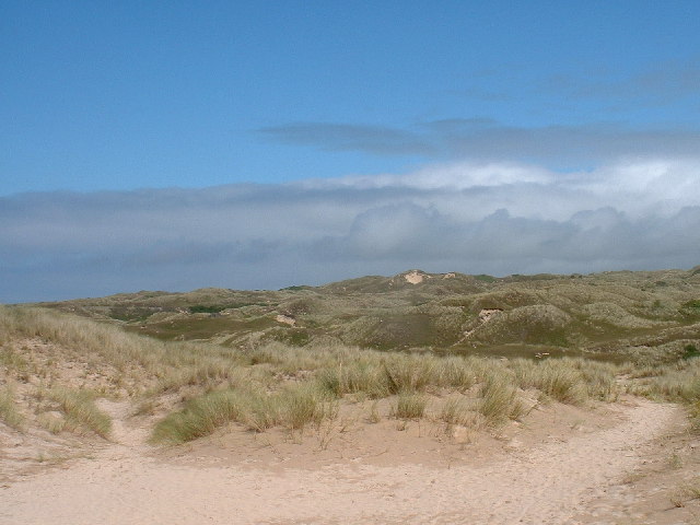
Towan (from Cornish: Tewyn, meaning "sand dune") is found in many placenames in Cornwall (Porthtowan for example). However, The Towans usually refers to the three-mile (5 km) stretch of coastal dunes which extends north-east from the estuary of the River Hayle (at 50°11′33″N 5°25′52″W / 50.19256°N 5.43111°W) to Gwithian beach (at 50°13′48″N 5°23′29″W / 50.22991°N 5.39145°W) with a midpoint near Upton (at 50°12′38″N 5°24′28″W / 50.21053°N 5.40768°W). The South West Coast Path crosses the towans.
The Towans are bounded to the south-east by Phillack village and the B3301 Hayle to Portreath road; to the north-west, the dunes face St Ives Bay across an intertidal beach. Substantial areas of The Towans rise more than 50 metres (160 ft) above sea level, the highest point being 72 metres (236 ft) at Phillack Towans. The southern half of The Towans is in Hayle civil parish and the northern half in Gwinear-Gwithian civil parish. The southern half was in Phillack parish until 1935 when Phillack was absorbed into the parish of Hayle.
Although 'The Towans' refers to the whole stretch, individual areas of the dunes have their own identities. Those named by Ordnance Survey on its mapping are (from south-west to north-east) Lelant Towans, Hayle Towans, Riviere Towans, Mexico Towans, Common Towans, Phillack Towans, Upton Towans and Gwithian Towans.
Much of the area falls within the Gwithian to Mexico Towans SSSI (Site of Special Scientific Interest), noted for both its geological and biological interest. Two areas of the site are also Local Nature Reserves. Upton Towans is owned by the Cornwall Wildlife Trust. It is a habitat of sand dune and grassland suited to a variety of wildlife and plants including the pyramidal orchid, glow worm, silver-studded blue butterfly, and skylark. Species in Gwithian Towans Local Nature Reserve include skylarks and adders.
Gwithian Towans cover the site of a Bronze Age farm which has been excavated although no remains are visible.[citation needed]
Upton Town was previously known as Great Towan, which contained an arable farm known as Upton Barton, and included a large area of towan grazing. At an uncertain date, sometime after 1650 the farmhouse was buried overnight with sand, following the frontal collapse of a high sand dune; the occupants escaped through the upper windows. The remains have not been since the winter of 1808–09. The evidence for Upton Barton was lost with the bombing of the Ordnance Survey, in Southampton during World War II.
In 1879 the Reverend F Hockin, rector of Phillack, enclosed approximately 9 acres (3.6 ha) for tillage giving employment to a large number of unemployed men. A large area of the Towans was already grazed.
Riviere Farm was put out to tender in 1888, containing a farm house, 88 acres (36 ha) of pasture and arable land and 90 acres (36 ha) acres of Common Towans ″within a ring fence″.
Hub AI
The Towans AI simulator
(@The Towans_simulator)
The Towans
Towan (from Cornish: Tewyn, meaning "sand dune") is found in many placenames in Cornwall (Porthtowan for example). However, The Towans usually refers to the three-mile (5 km) stretch of coastal dunes which extends north-east from the estuary of the River Hayle (at 50°11′33″N 5°25′52″W / 50.19256°N 5.43111°W) to Gwithian beach (at 50°13′48″N 5°23′29″W / 50.22991°N 5.39145°W) with a midpoint near Upton (at 50°12′38″N 5°24′28″W / 50.21053°N 5.40768°W). The South West Coast Path crosses the towans.
The Towans are bounded to the south-east by Phillack village and the B3301 Hayle to Portreath road; to the north-west, the dunes face St Ives Bay across an intertidal beach. Substantial areas of The Towans rise more than 50 metres (160 ft) above sea level, the highest point being 72 metres (236 ft) at Phillack Towans. The southern half of The Towans is in Hayle civil parish and the northern half in Gwinear-Gwithian civil parish. The southern half was in Phillack parish until 1935 when Phillack was absorbed into the parish of Hayle.
Although 'The Towans' refers to the whole stretch, individual areas of the dunes have their own identities. Those named by Ordnance Survey on its mapping are (from south-west to north-east) Lelant Towans, Hayle Towans, Riviere Towans, Mexico Towans, Common Towans, Phillack Towans, Upton Towans and Gwithian Towans.
Much of the area falls within the Gwithian to Mexico Towans SSSI (Site of Special Scientific Interest), noted for both its geological and biological interest. Two areas of the site are also Local Nature Reserves. Upton Towans is owned by the Cornwall Wildlife Trust. It is a habitat of sand dune and grassland suited to a variety of wildlife and plants including the pyramidal orchid, glow worm, silver-studded blue butterfly, and skylark. Species in Gwithian Towans Local Nature Reserve include skylarks and adders.
Gwithian Towans cover the site of a Bronze Age farm which has been excavated although no remains are visible.[citation needed]
Upton Town was previously known as Great Towan, which contained an arable farm known as Upton Barton, and included a large area of towan grazing. At an uncertain date, sometime after 1650 the farmhouse was buried overnight with sand, following the frontal collapse of a high sand dune; the occupants escaped through the upper windows. The remains have not been since the winter of 1808–09. The evidence for Upton Barton was lost with the bombing of the Ordnance Survey, in Southampton during World War II.
In 1879 the Reverend F Hockin, rector of Phillack, enclosed approximately 9 acres (3.6 ha) for tillage giving employment to a large number of unemployed men. A large area of the Towans was already grazed.
Riviere Farm was put out to tender in 1888, containing a farm house, 88 acres (36 ha) of pasture and arable land and 90 acres (36 ha) acres of Common Towans ″within a ring fence″.
Recent media