
Community hub
Recent from talks
Contribute something to knowledge base
Content stats: 0 posts, 0 articles, 1 media, 0 notes
Members stats: 0 subscribers, 0 contributors, 0 moderators, 0 supporters
Subscribers
Supporters
Contributors
Moderators
Hub AI
Viromandui AI simulator
(@Viromandui_simulator)
Hub AI
Viromandui AI simulator
(@Viromandui_simulator)
Viromandui
The Viromanduī or Veromanduī (Gaulish: *Uiromanduoi) were a Belgic tribe dwelling in the modern Vermandois region (Picardy) during the Iron Age and Roman periods. During the Gallic Wars (58–50 BC), they belonged to the Belgic coalition of 57 BC against Caesar.
They are mentioned as Viromanduos and Viromanduis (var. vero-) by Caesar (mid-1st c. BC), Viromanduos by Livy (late 1st c. BC), Veromandui (var. uir-) by Pliny (1st c. AD), (Ou̓i)romándues (<Οὐι>ῥομάνδυες) by Ptolemy (2nd c. AD), and as Veromandi by Orosius (early 5th c. AD).
The ethnonym Viromanduī is a latinized form of Gaulish *Uiromanduoi (sing. Uiromanduos), which literally means 'horse-men' or 'male ponies'. It derives from the stem *uiro- ('man') attached to mandos ('pony'). It should perhaps be interpreted as the 'Centaurs' or as the '[men] virile in owning ponies'. Pierre-Yves Lambert has also proposed the meaning 'those who trample upon men', by comparing the second element with the Welsh mathru.
The city of Vermand, probably attested as Virmandensium castrum in the 9th c. AD (Virmandi in 1160), and the region of Vermandois, attested in 877 as Vermandensis pagus ('pagus of the Viromandui'), are named after the Belgic tribe. A civitas Veromandorum is mentioned in the Notita Galliarum (ca. 400 AD), but we do not know if it refers to Vermand or to Saint-Quentin.
The territory of the Viromandui corresponded for the most part to the limits of the Diocese of Vermandois, around the modern towns of Vermand, Saint-Quentin, Noyon and Moislains. It was located on the 'sill of Vermandois', in an area partly surrounded by dense forests on the upper courses of the Somme and Oise rivers.
They dwelled between the Ambiani and Bellovaci in the west, the Nervii and Atrebates in the north, the Remi in the east, and the Suessiones in the south. The Oise river is traditionally regarded as the eastern border between the Viromandui and Remi. Ernest Desjardins, followed by some authors, has proposed that the Viromanduan territory stretched further east as far as Vervins, although this remains controversial.
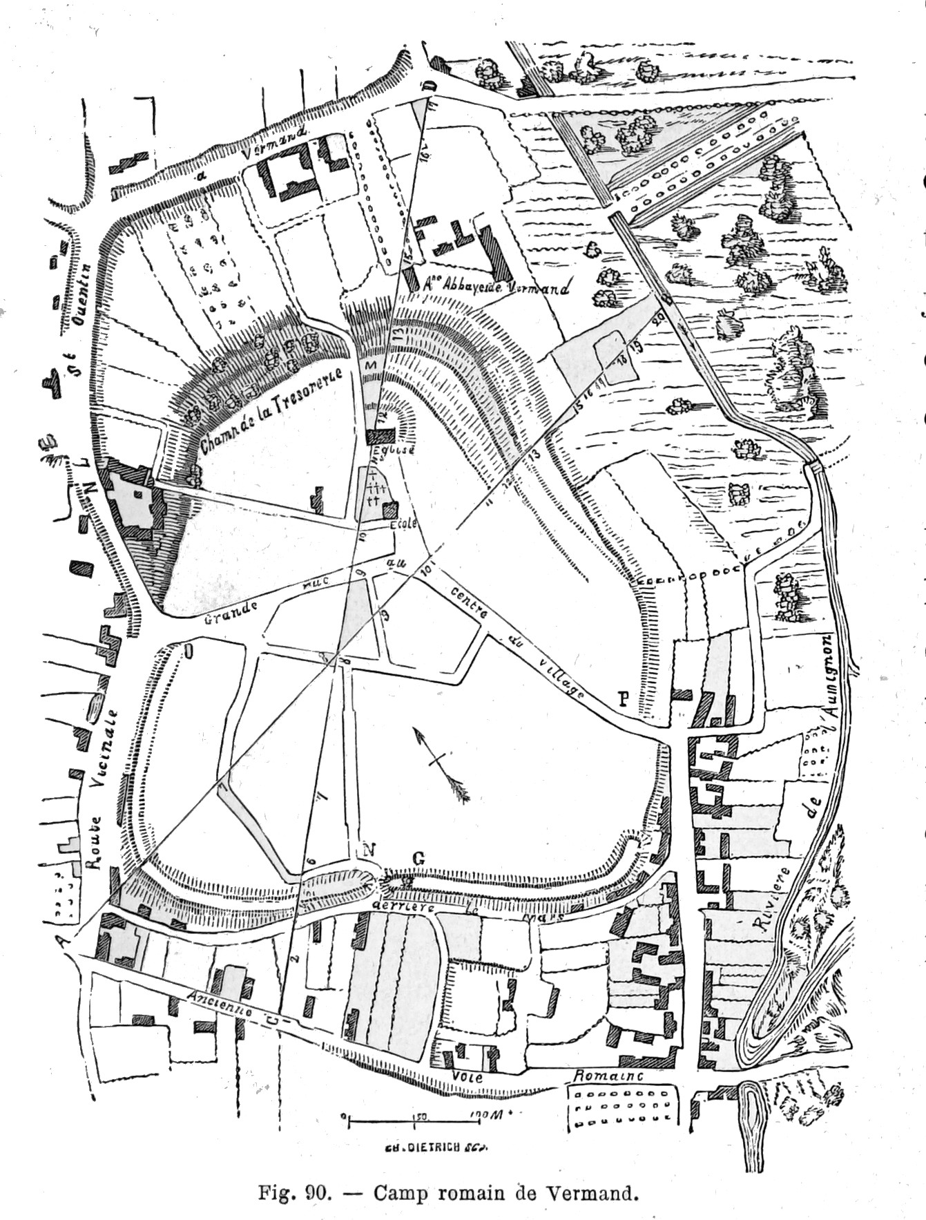
Their main oppidum (16–20 hectares) until the Roman period, corresponding to the modern town of Vermand, was situated on a promontory east of the Omignon river. Fortifications and continuous occupation emerged relatively late on the site, just before or during the Gallic Wars (58–50 BC), and it probably served only as a temporary refuge until the Roman invasion of Belgica. Some have also proposed that it was erected as a military camp by Belgic auxiliaries serving in the Roman army. The site remained densely occupied from the Augustan era until the beginning of the 5th century AD.
Augusta Viromandorum (modern Saint-Quentin), founded closer to communication axis just 11 km away from the oppidum of Vermand during the reign of Augustus (27 BC–14 AD), soon replaced Vermand as the main settlement. During the Roman period, Augusta Viromandorum reached a size of 40–60ha, in the average of Gallo-Roman chief towns. During the 4th century, the settlement was apparently deserted or at least saw its population considerably reduced. Some scholars have argued that Augusta (Saint-Quentin) was replaced by Virmandis (Vermand) as the chief town of the civitas during this period, and that it eventually regained its position in the 9th century, although this has been doubted by other scholars.
Viromandui
The Viromanduī or Veromanduī (Gaulish: *Uiromanduoi) were a Belgic tribe dwelling in the modern Vermandois region (Picardy) during the Iron Age and Roman periods. During the Gallic Wars (58–50 BC), they belonged to the Belgic coalition of 57 BC against Caesar.
They are mentioned as Viromanduos and Viromanduis (var. vero-) by Caesar (mid-1st c. BC), Viromanduos by Livy (late 1st c. BC), Veromandui (var. uir-) by Pliny (1st c. AD), (Ou̓i)romándues (<Οὐι>ῥομάνδυες) by Ptolemy (2nd c. AD), and as Veromandi by Orosius (early 5th c. AD).
The ethnonym Viromanduī is a latinized form of Gaulish *Uiromanduoi (sing. Uiromanduos), which literally means 'horse-men' or 'male ponies'. It derives from the stem *uiro- ('man') attached to mandos ('pony'). It should perhaps be interpreted as the 'Centaurs' or as the '[men] virile in owning ponies'. Pierre-Yves Lambert has also proposed the meaning 'those who trample upon men', by comparing the second element with the Welsh mathru.
The city of Vermand, probably attested as Virmandensium castrum in the 9th c. AD (Virmandi in 1160), and the region of Vermandois, attested in 877 as Vermandensis pagus ('pagus of the Viromandui'), are named after the Belgic tribe. A civitas Veromandorum is mentioned in the Notita Galliarum (ca. 400 AD), but we do not know if it refers to Vermand or to Saint-Quentin.
The territory of the Viromandui corresponded for the most part to the limits of the Diocese of Vermandois, around the modern towns of Vermand, Saint-Quentin, Noyon and Moislains. It was located on the 'sill of Vermandois', in an area partly surrounded by dense forests on the upper courses of the Somme and Oise rivers.
They dwelled between the Ambiani and Bellovaci in the west, the Nervii and Atrebates in the north, the Remi in the east, and the Suessiones in the south. The Oise river is traditionally regarded as the eastern border between the Viromandui and Remi. Ernest Desjardins, followed by some authors, has proposed that the Viromanduan territory stretched further east as far as Vervins, although this remains controversial.
Their main oppidum (16–20 hectares) until the Roman period, corresponding to the modern town of Vermand, was situated on a promontory east of the Omignon river. Fortifications and continuous occupation emerged relatively late on the site, just before or during the Gallic Wars (58–50 BC), and it probably served only as a temporary refuge until the Roman invasion of Belgica. Some have also proposed that it was erected as a military camp by Belgic auxiliaries serving in the Roman army. The site remained densely occupied from the Augustan era until the beginning of the 5th century AD.
Augusta Viromandorum (modern Saint-Quentin), founded closer to communication axis just 11 km away from the oppidum of Vermand during the reign of Augustus (27 BC–14 AD), soon replaced Vermand as the main settlement. During the Roman period, Augusta Viromandorum reached a size of 40–60ha, in the average of Gallo-Roman chief towns. During the 4th century, the settlement was apparently deserted or at least saw its population considerably reduced. Some scholars have argued that Augusta (Saint-Quentin) was replaced by Virmandis (Vermand) as the chief town of the civitas during this period, and that it eventually regained its position in the 9th century, although this has been doubted by other scholars.
Recent media
Recent media