Recent from talks
Vessel monitoring system
Knowledge base stats:
Talk channels stats:
Members stats:
Vessel monitoring system
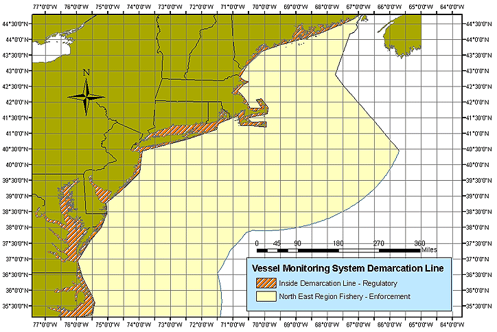
Vessel Monitoring Systems (VMS) is a general term to describe systems that are used in commercial fishing to allow environmental and fisheries regulatory organizations to track and monitor the activities of fishing vessels. They are a key part of monitoring control and surveillance (MCS) programs at national and international levels. VMS may be used to monitor vessels in the territorial waters of a country or a subdivision of a country, or in the Exclusive Economic Zones (EEZ) that extend 200 nautical miles (370 kilometres) from the coasts of many countries. VMS systems are used to improve the management and sustainability of the marine environment, through ensuring proper fishing practices and the prevention of illegal fishing, and thus protect and enhance the livelihoods of fishermen.
The exact functionality of a VMS system and the associated equipment varies with the requirements of the nation of the vessel's registry, and the regional or national water in which the vessel is operating. Within regional and national VMS initiatives there are also sub-divisions which apply different functionality to different vessel categories. Categories may be size or type of vessel or activity. For example:
In this discussion, VMS relates specifically to fisheries management systems. VMS describes the specific application of monitoring commercial fishing boats. It is not to be confused with vessel traffic service (VTS) which is describes the specific application of monitoring marine traffic primarily for safety and efficiency in ports and busy waterways. It is also not to be confused with specific communication technologies such as AIS, Iridium, Inmarsat, Argos, GPRS which relate to the communication method on which data is transmitted. Different VMS systems will use different communication technologies depending on the functionality requirements imposed by a national or regional VMS initiative.
The cost of VMS components will vary according to the functionality requirements of the specific system being implemented. In general the higher the functionality the more expensive the equipment and required data link (airtime costs). The cost of a VMS system therefore varies and thus the level of government subsidy (if any) varies according to national and regional requirements. EU and US VMS systems require expensive onboard equipment and large amounts of data to be transmitted over satellite link resulting in high airtime charges, but also provide a very high level of functionality. In other regions where per vessel cost and huge fleet sizes are an issue, communication technologies such as AIS are used which significantly reduce equipment and airtime costs whilst delivering acceptable basic VMS system functionality.
VMS is intended principally for fisheries management, but the country using it may use the data for other purposes. See the broad framework of Monitoring control and surveillance.
Among all the most basic purposes is to monitor the movement of VMS-equipped vessels with respect to restricted fishing areas. A given vessel may have approval to fish in a restricted area, to transit through it without fishing, or it may not be allowed in the area.
Not all VMS systems are required to record and transmit catch reports. On the systems with separate PCs, it is reasonably easy to distribute separate software, although the fishermen may or may not be able to install it without assistance and additional equipment. For VMS with dedicated PCs, additional software can be made part of software support with established channels.
In the EU and US there is a distinct trend to making catch reporting part of an overall MCS program, although current VMS systems rarely integrate this capability with position reporting. One system that does do this is Fulcrum Maritime Systems Limited's Vessel Tracking Service which uses the latest data rich satellite application technology to enable electronic catch reports to be sent from the vessel to the VMS directly and automatically sends the report and vessel position data to the appropriate RFO or Regulatory Fishing Body, such as the NEAFC.
Hub AI
Vessel monitoring system AI simulator
(@Vessel monitoring system_simulator)
Vessel monitoring system
Vessel Monitoring Systems (VMS) is a general term to describe systems that are used in commercial fishing to allow environmental and fisheries regulatory organizations to track and monitor the activities of fishing vessels. They are a key part of monitoring control and surveillance (MCS) programs at national and international levels. VMS may be used to monitor vessels in the territorial waters of a country or a subdivision of a country, or in the Exclusive Economic Zones (EEZ) that extend 200 nautical miles (370 kilometres) from the coasts of many countries. VMS systems are used to improve the management and sustainability of the marine environment, through ensuring proper fishing practices and the prevention of illegal fishing, and thus protect and enhance the livelihoods of fishermen.
The exact functionality of a VMS system and the associated equipment varies with the requirements of the nation of the vessel's registry, and the regional or national water in which the vessel is operating. Within regional and national VMS initiatives there are also sub-divisions which apply different functionality to different vessel categories. Categories may be size or type of vessel or activity. For example:
In this discussion, VMS relates specifically to fisheries management systems. VMS describes the specific application of monitoring commercial fishing boats. It is not to be confused with vessel traffic service (VTS) which is describes the specific application of monitoring marine traffic primarily for safety and efficiency in ports and busy waterways. It is also not to be confused with specific communication technologies such as AIS, Iridium, Inmarsat, Argos, GPRS which relate to the communication method on which data is transmitted. Different VMS systems will use different communication technologies depending on the functionality requirements imposed by a national or regional VMS initiative.
The cost of VMS components will vary according to the functionality requirements of the specific system being implemented. In general the higher the functionality the more expensive the equipment and required data link (airtime costs). The cost of a VMS system therefore varies and thus the level of government subsidy (if any) varies according to national and regional requirements. EU and US VMS systems require expensive onboard equipment and large amounts of data to be transmitted over satellite link resulting in high airtime charges, but also provide a very high level of functionality. In other regions where per vessel cost and huge fleet sizes are an issue, communication technologies such as AIS are used which significantly reduce equipment and airtime costs whilst delivering acceptable basic VMS system functionality.
VMS is intended principally for fisheries management, but the country using it may use the data for other purposes. See the broad framework of Monitoring control and surveillance.
Among all the most basic purposes is to monitor the movement of VMS-equipped vessels with respect to restricted fishing areas. A given vessel may have approval to fish in a restricted area, to transit through it without fishing, or it may not be allowed in the area.
Not all VMS systems are required to record and transmit catch reports. On the systems with separate PCs, it is reasonably easy to distribute separate software, although the fishermen may or may not be able to install it without assistance and additional equipment. For VMS with dedicated PCs, additional software can be made part of software support with established channels.
In the EU and US there is a distinct trend to making catch reporting part of an overall MCS program, although current VMS systems rarely integrate this capability with position reporting. One system that does do this is Fulcrum Maritime Systems Limited's Vessel Tracking Service which uses the latest data rich satellite application technology to enable electronic catch reports to be sent from the vessel to the VMS directly and automatically sends the report and vessel position data to the appropriate RFO or Regulatory Fishing Body, such as the NEAFC.
Recent media