Hubbry Logo
Via AureliaVia AureliaMain
Open search
Via Aurelia
Community hub
Via Aurelia
logo
8 pages, 0 posts
0 subscribers
Be the first to start a discussion here.
Via Aurelia
Via Aurelia
from Wikipedia
Route of Via Aurelia (in yellow)

Key Information

The Via Aurelia (lit.'Aurelian Way') is a Roman road in Italy constructed in approximately 241 BC. The project was undertaken by Gaius Aurelius Cotta, who at that time was censor.[1] Cotta had a history of building roads for Rome, as he had overseen the construction of a military road in Sicily (as consul in 252 BC, during the First Punic War) connecting Agrigentum (modern Agrigento) and Panormus (modern Palermo).[2]

Background

[edit]

In the middle Republic, a series of roads were built throughout Italy to serve the needs of Roman expansion, including swift army movements and reasonably quick communication with Roman colonies spread throughout Italy. There also was the unintended (but beneficial) consequence of an increase in trade among Italian cities and with Rome. The roads were standardized to 15 feet (4.6 m) wide allowing two chariots to pass, and distance was marked with milestones.[3]

The Via Aurelia was constructed as a part of this road construction campaign, which began in 312 BC with the building of the Via Appia. Other roads included in this construction period were the Viae Amerina (c. 231 BC), Flaminina, Clodia, Aemilia, Cassia, Valeria (c. 307 BC), and Caecilia (c. 283 BC).[4]

Route

[edit]

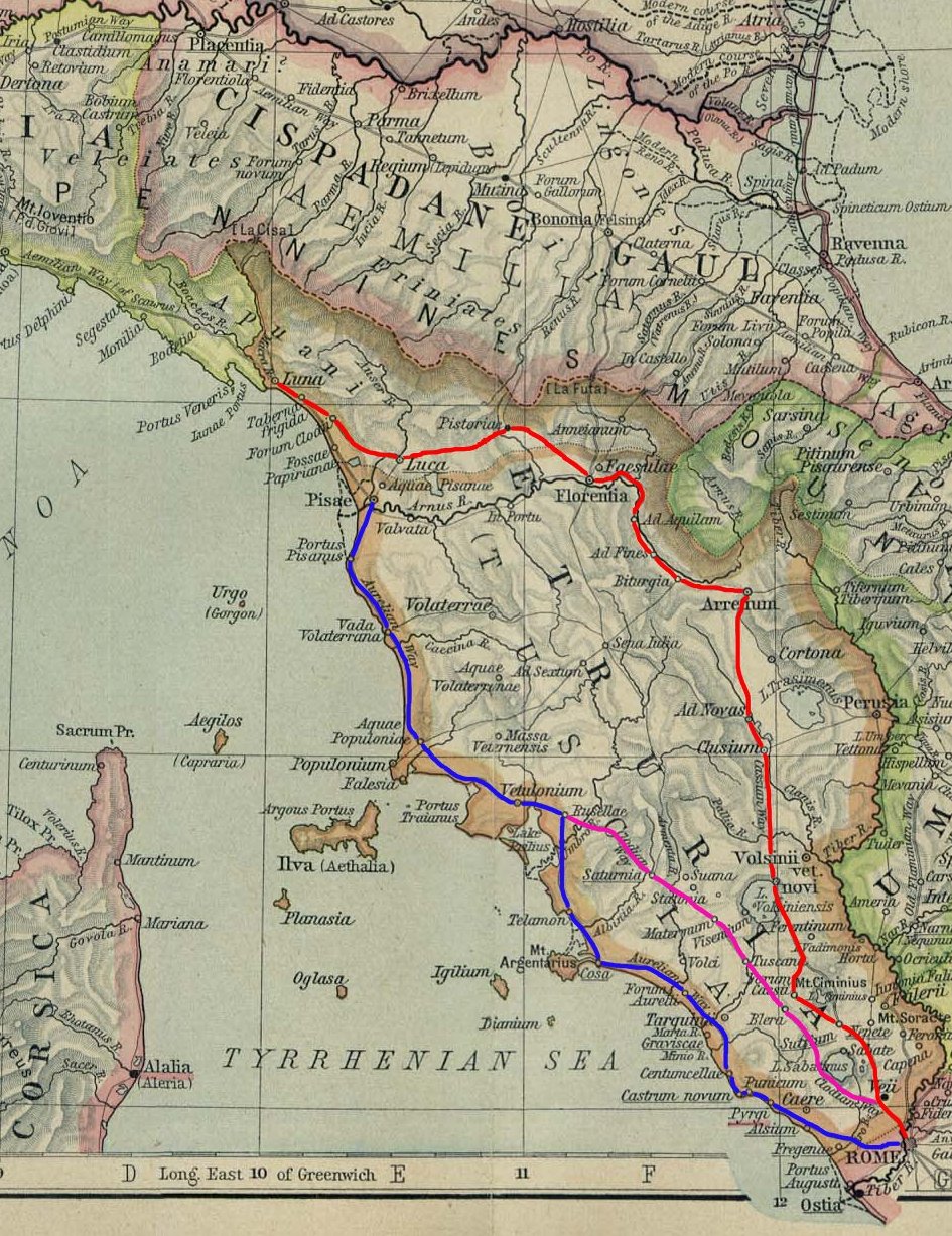
The Via Aurelia crossed the Tiber by way of the bridge Pons Aemilius, then exited Rome from its western side. After the Emperor Aurelian built a wall around Rome (c. 270–273 CE), the Via Aurelia exited from the Porta Aurelia (gates). The road then ran about 25 miles (40 km) to Alsium on the Tyrrhenian coast, north along the coast to Vada Volaterrana, Cosa, and Pisae (modern-day Pisa). There the original length of the Via Aurelia terminated.[5]

This was an especially important route during the early and middle Republic because it linked Rome, Cosa, and Pisae. Cosa was an important colony and military outpost in Etruria, and Pisae was the only port between Genua and Rome. Consequently, it was an important naval base for the Romans in their wars against the Ligurians, Gauls and Carthaginians.[6]

The Via Aurelia later was extended by roughly 320 km (200 mi) in 109 BC by the Via Aemilia Scauri, constructed by M. Aemilius Scaurus. This road led to Dertona (modern Tortona), Placentia, Cremona, Aquilea, and Genua, from which travellers could proceed to Gallia Narbonensis (southern France) by way of the Via Postumia.[1]

This followed some rebuilding of the road by the same person during his consulship in 119 BC.[7]

By the time of the high Empire, travellers could go from Rome by way of the Via Aurelia across the Alps on the Via Julia Augusta to either northern France or Gades (modern Cádiz, Spain).[8]

The modern Strada Statale 1 Aurelia occupies the same route, and colloquially is still referred to as La Via Aurelia.

Roman bridges

[edit]

There are the remains of several Roman bridges along the road, including the Cloaca di Porta San Clementino, Ponte del Diavolo, Primo Ponte, and the Secondo Ponte (the last three in Sta Marinella).[citation needed]

See also

[edit]

References

[edit]
[edit]
Revisions and contributorsEdit on WikipediaRead on Wikipedia
from Grokipedia
The Via Aurelia, also known as the Aurelian Way, is an ancient Roman road in constructed around 241 BC by the censor Aurelius Cotta to connect with newly established colonies in and facilitate military and trade movements along the Tyrrhenian coast. Originally spanning from Rome's Porta Aurelia gate through key settlements such as Forum Aurelii (near modern Fregene) to the colony of (near modern Ansedonia), the road covered an initial distance of about 96 Roman miles (roughly 142 km), emphasizing coastal access for Rome's expanding influence in . During the late and early , the route was progressively extended northward to , Luna (modern Luni in ), and (Genoa), incorporating branches like the Via Aemilia Scauri for further connectivity; by the 2nd century AD, as documented in the , the full Via Aurelia stretched approximately 797 Roman miles (about 1,180 km) from to Arelate (Arles) in , linking the to via coastal and inland variants such as the Via Aurelia Nova. This infrastructure played a crucial role in the Roman road system's expansion, enabling rapid legionary deployments at speeds up to 4 miles per hour, efficient courier services (reducing travel from Arles to to about eight days), and the transport of goods like , wine, and , while fostering cultural and across the empire's western Mediterranean frontiers. Today, segments of the Via Aurelia survive as archaeological sites, including milestones, bridges like the Ponte della Badia near , and paved sections in and , with much of its path overlaid by the modern SS1 Aurelia highway, underscoring its enduring legacy in shaping Italy's coastal infrastructure.

History

Origins and Construction

The construction of the Via Aurelia was initiated around 241 BC by the Roman censor Gaius Aurelius Cotta, as part of Rome's broader expansion into following the conclusion of the . This project represented one of the earliest major undertaken by the censors of the middle , aimed at integrating newly acquired territories and strengthening Roman control over the western coast. Cotta, serving alongside Marcus Fabius Buteo, oversaw the road's development to facilitate administrative oversight and connect directly to emerging coastal settlements. This followed the establishment of the colony at in 273 BC, aiming to link to these new settlements. The primary purpose of the Via Aurelia was to provide military access to coastal colonies and ports, enhancing Rome's strategic position along the during a period of heightened naval and territorial ambitions post-First Punic War. By linking the capital to key Etruscan sites, the road supported rapid troop movements and supply lines, crucial for defending against potential threats and consolidating gains from the war against . The initial route extended from through key settlements like Alsium (modern Palo) to the colony of , covering approximately 120 Roman miles (178 km), traversing the Hill and following the to bolster these defensive and logistical objectives. The route exited from the Porta Aurelia gate on the Janiculum Hill, integrating with Rome's urban defenses. This early phase of the Via Aurelia adhered to emerging Roman engineering standards, with a standard width of 4.2 meters (equivalent to 15 Roman feet) to accommodate wheeled traffic such as carts and wagons. Construction employed gravel for the foundational layers and stone paving for the surface, ensuring durability over the varied terrain while minimizing maintenance needs in the initial years.

Extensions and Developments

In 109 BC, during his tenure as censor, Marcus Aemilius Scaurus oversaw the construction of the Via Aemilia Scauri, extending the Via Aurelia northward from Pisae through Luni to (modern ), adding approximately 200 km. This expansion enhanced connectivity to the Via Postumia and facilitated access to and beyond. During the imperial period, initiated major enhancements to the Via Aurelia around 12 BC, renaming portions as the Via Julia Augusta and incorporating resurfacing along with improved drainage systems to address the demands of the rugged coastal landscape. These upgrades, spanning from Vada Sabata to the Var River (about 150 km), bolstered the road's durability and efficiency for military and commercial use. From the AD, oversight of the Via Aurelia fell to specialized officials known as curatores viarum, who coordinated routine upkeep and major restorations, including responses to environmental damage from floods and disruptions caused by wars. Such interventions ensured the road's operational integrity amid the empire's expanding challenges. Among the auxiliary developments, the Via Clodia emerged as a key branch near Rome, diverging to offer an inland alternative for coastal-bound traffic and linking the Via Aurelia with the Via Cassia. This interconnection supported diversified access to Etruscan regions and thermal sites along the western itinerary.

Route

Southern Segment

The Southern Segment of the Via Aurelia, constructed around 241 BCE by the censor Gaius Aurelius Cotta, originated in Rome at the area later known as the Porta Aurelia, located near Vatican Hill on the western side of the city. The road crossed the Tiber River, which was later facilitated by the Pons Aemilius (constructed from 179 BC), Rome's oldest stone bridge, before ascending the Janiculum Hill and exiting the urban area. From there, it traversed the undulating countryside of the right bank, passing through early stations such as Forum Aurelii (near modern Fregene) after about 40 kilometers from Rome. Continuing westward, the route paralleled the Tyrrhenian coast, reaching the port town of Alsium (modern Palo). Beyond Alsium, it proceeded along the shoreline to Pyrgi, the principal harbor of the Etruscan city of (modern ), then to Graviscae (near ), and culminated at the Roman of (modern Ansedonia), established in 273 BCE as a strategic outpost against Etruscan and maritime threats. This segment, spanning roughly 120 Roman miles (178 km) in total, emphasized coastal connectivity while avoiding excessive inland detours. The terrain presented notable challenges, including volcanic soils in the Sabatini Mountains near , which required careful drainage and stabilization, and marshy coastal plains around , where the road's engineers maintained gentle gradients—typically no steeper than 1:20—to ensure reliable passage for carts and legions. Roman construction techniques, such as agger (raised embankments) and culverts, mitigated flooding and in these areas. Among the key infrastructure points, a mansio at Alsium served as an essential station for travelers, providing lodging, stables, and relay services for the , the imperial postal and transport system that facilitated rapid communication and official dispatches along the route. This original segment up to laid the foundation for later extensions northward to Pisae, enhancing Rome's control over and the western coast.

Northern Extension

The northern extension of the Via Aurelia commenced at the colony of in southern and extended northward along the Tyrrhenian coast, integrating with later Roman infrastructure to connect to . This segment traversed Etruscan strongholds such as , a major iron production center, before reaching Vada Volaterrana and the port city of (modern ), facilitating maritime trade links. The route then proceeded to Luni (ancient Luna), where it passed near significant marble quarries that supplied imperial building projects, as evidenced by archaeological traces along the coastal path. From Luni, the extension incorporated the Via Aemilia Scauri, constructed in 109 BC by censor Marcus Aemilius Scaurus, which carried the Aurelian network over the Apennines via passes like the Passo del Bracco (elevation 615 m) toward . This linkage at Luni enabled efficient overland access to , bypassing longer sea voyages and supporting military logistics in the northwest. The full northern stretch spanned approximately 280 km, with the Ligurian portion demanding engineering adaptations such as terracing to manage steeper gradients in the hilly terrain. To circumvent marshy lowlands, the path included coastal deviations, hugging the rugged shoreline through sites like Vada Volaterrana while veering inland across valleys and ridges en route to Genua, passing settlements such as Moneglia, , Lavagna, and . Reconstructions rely on ancient itineraries like the Itinerarium Antonini and the , which document mansiones and staging posts along this integrated corridor.

Infrastructure

Bridges and Engineering Features

The Pons Aemilius, serving as the starting point for the Via Aurelia Vetus in Rome, represents the earliest known stone bridge associated with the road's network. Constructed initially with stone piers in 179 BC by the censors M. Fulvius Nobilior and M. Aemilius Lepidus, it was the first all-stone bridge over the Tiber River, replacing earlier wooden structures. The arches were added in 142 BC under the censorship of P. Cornelius Scipio Africanus and L. Mummius Achaicus, marking a significant engineering advancement in Roman bridge construction with its use of voussoir arches for enhanced stability. This bridge facilitated the road's departure from the city toward the Janiculum Hill and beyond, underscoring its integral role in the Via Aurelia's southern infrastructure. Along the coastal segment near , the Via Aurelia featured several minor bridges designed to cross local streams, exemplifying practical Roman for traversing uneven . At least four such structures, documented in archaeological surveys, employed opus quadratum construction with large stone blocks, likely local and , to form single or low-arched spans suitable for the road's width. Dated to the , these bridges, including remnants at sites like the Ponte di Apollo, Ponte di Largo Impero, Ponte di Vignacce, and Ponte di Via Roma, incorporated radial ashlars and substructures for durability against seasonal flooding. Their modest scale—typically 4-5 meters wide—reflected the road's focus on efficient coastal passage rather than monumental display. Beyond bridges, the Via Aurelia incorporated adaptive features to manage environmental challenges, particularly in marshy coastal zones and hilly interiors. Culverts, often formed from stone-lined channels or terracotta pipes, directed water runoff beneath the roadway to prevent erosion and flooding in low-lying areas prone to stagnation. In steeper sections, retaining walls constructed from locally sourced stone stabilized embankments, preventing landslides and maintaining the road's cambered profile for optimal drainage. Notably, the route avoided major aqueduct integrations, relying instead on these localized solutions to sustain traffic flow without complex hydraulic systems. The engineering legacy of the Via Aurelia's bridges and features waned with the Roman Empire's decline, as neglect led to widespread deterioration by the medieval period. Many structures, including portions of the , suffered collapses due to flood damage and lack of maintenance, with only fragmented arches surviving into the . Partial reconstructions occurred during the , such as repairs to the following 16th-century floods under , though these efforts were limited and often incorporated medieval reinforcements rather than full restorations.

Milestones and Waystations

The milestones () along the Via Aurelia consisted of cylindrical stone pillars erected every 1,000 paces (mille passus, approximately 1.48 km) to mark distances and facilitate navigation. These markers typically featured inscriptions indicating the cumulative distance from , often accompanied by dedications to the emperor or official overseeing the road's construction or repair. A notable Republican-era example near in the Albegna Valley, discovered archaeologically, is a limestone column inscribed with a dedication to M. Aemilius Scaurus, the builder of the road's extension in 109 BC, and marking 91 miles (millia passuum) from . Signage on the Via Aurelia evolved from simple Republican markers denoting basic distances to more elaborate imperial inscriptions honoring road builders and rulers. Early Republican pillars were often plain, focusing on mileage, while later examples under and his successors incorporated elements, such as imperial titles and restoration details. For instance, an Augustan milestone in the Laghet Valley along the northern extension (Via Julia Augusta) is inscribed with "DCVII" (607 miles from ) and credits for its placement. This shift reflected the growing emphasis on imperial patronage in infrastructure projects, with dedications like those to Scaurus transitioning into widespread honors for emperors during the . Waystations along the Via Aurelia included mutationes (horse-changing posts) and mansiones (inns for official travelers), spaced approximately every 25-30 km to support the relay system. These facilities allowed for swift horse relays and provided lodging, stables, and services for couriers, officials, and . Key sites listed in the (3rd century AD) include Alsium (modern Palo) and Pisae (modern ), where archaeological investigations have uncovered remains associated with such stations, including potential stable structures integrated into coastal settlements. At Alsium, excavations reveal Roman-era infrastructure supporting travel logistics near the Tyrrhenian coast, while at Pisae, evidence of roadside facilities aligns with the road's role as a major artery to . Approximately 26 milestones from the Via Aurelia and its extensions survive today, primarily housed in museums such as those in and Vintimiglia, offering critical evidence for dating construction phases and imperial interventions. These artifacts, often cylindrical or pillars 2-3 meters tall, underscore the road's logistical sophistication and enduring Roman standards.

Significance

Military and Administrative Role

The Via Aurelia facilitated critical military operations in western , enabling swift deployment of Roman legions during the and against Ligurian tribes. Constructed around 241 BC shortly after the , the road connected to the coastal colony of , which functioned as a key for Roman fleets combating Carthaginian forces and later supporting campaigns into Ligurian territory. This infrastructure allowed legions to advance at rates of approximately four , covering distances like the 180 miles from coastal outposts to interior strongholds with relative speed, as evidenced by relay stations spaced every 12 to 20 miles for resupply. During the (218–201 BC), the route's southern segment supported logistical movements without direct combat at itself. Its later northern extensions aided subjugation efforts against Ligurian tribes in the . Legions were periodically stationed at strategic points like for coastal defense and at Pisae, a colony founded in 180 BC, to maintain garrisons overlooking Ligurian highlands. Administratively, the Via Aurelia integrated into the broader Roman governance structure, particularly as a conduit within the , the empire's official relay system for couriers and officials. Established under , this network utilized major roads like the Aurelia to expedite imperial dispatches, tax collection, and oversight of provincial administration, with mutatio stations providing mounts and lodging exclusively for state use. The road's alignment supported travel from to emerging provinces in via connections like the , ensuring efficient bureaucratic control over western territories. By the AD, messengers could traverse segments from Arles to —over 550 miles—in as little as eight days, underscoring its role in sustaining administrative cohesion. The road's construction also bolstered colonial initiatives, directly linking settlements like , founded as a Latin in 273 BC on confiscated Etruscan land to house around 300 Roman families tasked with securing the Tyrrhenian coast. This placement along the Via Aurelia emphasized its military-administrative purpose: veteran settlers and citizen-colonists enforced Roman , suppressing Etruscan rebel elements in the Ager Cosanus and preventing resurgence amid post-conquest instability. Pisae similarly benefited, with its 180 BC establishment reinforcing legionary presence for territorial consolidation. In a defensive capacity, northern sections of the Via Aurelia near were fortified during the to counter persistent Alpine and Ligurian incursions, as Roman engineers reinforced passes and outposts amid campaigns to pacify highland tribes. Extensions under figures like Aemilius Scaurus around 109 BC integrated these defenses, transforming the route into a bulwark against raids from the Apennine and Maritime , thereby stabilizing imperial frontiers in .

Economic and Trade Impact

The Via Aurelia played a pivotal role in facilitating trade between and the Tyrrhenian Sea ports, enabling the export of key agricultural products from , including grain, wine, and , which were transported along its coastal route to support the capital's system and broader Mediterranean commerce. This connectivity boosted regional production, as the road's alignment through fertile coastal plains allowed efficient movement of perishable goods from Etruscan heartlands to ports like and , integrating local estates into imperial supply chains. Its northern extension further enhanced resource extraction and transport, linking Roman markets to Ligurian timber supplies vital for and , while the of Luni served as a primary outlet for , quarried in the nearby and shipped across the empire for monumental projects. The road's infrastructure spurred by promoting the development of large villa estates along its path, particularly in , where landowners invested in specialized agriculture focused on and olive cultivation to capitalize on Rome's demand, transforming rural landscapes into productive commercial hubs. Toll stations, known as telonia, were established at key points such as Pisae, where duties were levied on passing goods, generating revenue for maintenance and imperial coffers while regulating the flow of merchandise like amphorae of wine and oil. These mechanisms not only incentivized but also supported the expansion of estate-based economies, with slaves often laboring on villas visible from the Via Aurelia's route, contributing to the agricultural surplus that underpinned Roman prosperity. In terms of market integration, the Via Aurelia connected inland producers to coastal emporia like , a major hub for the metal trade where iron smelted from Elban ores was processed and distributed via the road to Roman workshops and legions, fostering specialized industries in the region. This linkage extended to supporting the transport of from coastal raids, integrating slave labor into the agrarian and metallurgical economies along the route and amplifying the road's role in human and material exchanges. Following the empire's fall in the fifth century CE, the Via Aurelia experienced significant decline as maintenance lapsed and trade networks fragmented, leading to depopulation of associated villas and ports like Luni, where exports ceased amid economic contraction. However, remnants of the road revived in medieval , particularly from the eleventh century onward, as pilgrims and merchants repurposed sections for overland travel to , facilitating the resurgence of coastal commerce in wine, timber, and metals through and .

Legacy

Modern Alignment and Usage

The modern Strada Statale 1 (SS1) Via Aurelia closely parallels much of the ancient Roman road's path, tracing the Tyrrhenian coastline from to over approximately 700 kilometers. Established as part of Italy's state highway network in the 1920s and fully modernized with paving and systematization in 1928 under the Azienda Autonoma Statale delle Strade, it received further upgrades in the during Italy's post-war infrastructure boom to handle increased vehicular use. In urban areas, segments of the SS1 have been incorporated into local road systems, such as the Via Aurelia in Rome, which extends beyond the Grande Raccordo Anulare, and through Genoa, where it navigates dense city infrastructure. To alleviate congestion, bypass variants were developed in the 2000s and beyond, including the ongoing "Nuova Aurelia" project in Liguria, which introduces modern alignments and eco-friendly features while avoiding built-up zones. The highway plays a key role in contemporary transport and , forming part of the E45 European route and supporting coastal travel between major cities like and . Near , it experiences substantial daily traffic, often exceeding 20,000 vehicles, driven by commuter, commercial, and tourist flows along this vital corridor. Preservation initiatives have focused on restoring vulnerable sections to mitigate and safeguard archaeological overlays from environmental threats.

Archaeological Discoveries

Excavations at the Roman colony of , located along the route of the Via Aurelia in southwestern , were conducted primarily between 1948 and the 1950s under the direction of Frank E. Brown for the American Academy in , revealing extensive roadbeds integrated into the city's urban layout and several inscribed milestones marking distances from . These findings highlighted the road's role in connecting the colony to the capital, with preserved segments of the via demonstrating typical Roman construction techniques using layered gravel and stone. Further surveys in the mid-20th century uncovered additional milestones nearby, bearing imperial dedications that underscored the road's maintenance under later emperors. In the coastal area of , remains of multiple Roman bridges spanning the ancient Via Aurelia (known as the Aurelia vetus) have been documented, with significant portions brought to light through 20th-century restorations and studies, including efforts in the that exposed structural details following partial collapses. These features, such as the Bridge of Via Roma dating to the 2nd century BCE and constructed with large blocks forming a single flat arch, illustrate the road's adaptation to the rugged Tyrrhenian terrain. Other nearby bridges, like the Ponte del Diavolo and those at Largo Impero, similarly attest to the via's sophisticated hydraulics, with excavations confirming their alignment along the original coastal path. Recent advancements in archaeological culminated in the 2025 Itiner-e , a collaborative digital mapping initiative by the Universitat Autònoma de Barcelona and the University of Aarhus, which nearly doubled the documented extent of the Roman road network to 299,171 kilometers by integrating historical itineraries, epigraphic from over 8,000 milestones, and . This effort identified previously unknown or buried segments of the Via Aurelia near Luni, the road's northern terminus, extending the known network by approximately 50% in that region through analysis of topographic and aerial . The emphasized non-invasive techniques, including manual digitization of secondary roads, to reveal alignments obscured by modern development; its open-access digital atlas became publicly available in November 2025. Notable artifacts associated with the Via Aurelia include inscribed milestones from the era of Marcus Aemilius Scaurus, whose 109 BCE extensions (Via Aemilia Scauri) augmented the original route; several such stones, bearing dedications to imperial repairs, provide evidence of administrative oversight along the via. Additionally, 2015 geophysical surveys and targeted digs near uncovered pre-Roman alignments, likely Etruscan precursors to the Aurelia's path, including earthen tracks and stone revetments that suggest continuity in regional connectivity from the BCE. These discoveries, part of broader investigations into Etruria's rural landscapes, indicate that the Roman road often overlaid earlier local networks. Ongoing challenges to the preservation of Via Aurelia sites stem from urban expansion in coastal and peri-urban zones, which has led to the encroachment on archaeological contexts through and projects. Since the early , has advocated for enhanced protection of Italy's ancient as , exemplified by the 2004 Code of Cultural Heritage and Landscape and recent inscriptions like that of the Via Appia in 2024, urging integrated management plans to mitigate threats from development while promoting sustainable access.

References

Add your contribution
Related Hubs
User Avatar
No comments yet.