Recent from talks
Viticuso
Knowledge base stats:
Talk channels stats:
Members stats:
Viticuso
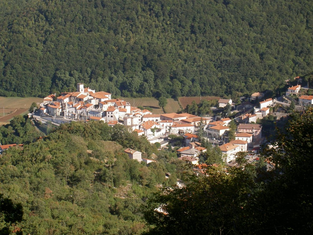
Viticuso is a comune (municipality) in the Province of Frosinone in the Italian region Lazio, located about 130 kilometres (81 mi) southeast of Rome and about 50 kilometres (31 mi) east of Frosinone.
Viticuso borders the following municipalities: Acquafondata, Cervaro, Conca Casale, Pozzilli, San Vittore del Lazio, Vallerotonda.
The town is situated at approximately 860 meters above sea level and is surrounded by small peaks that rise to about 1260 meters above sea level within the municipal territory, forming a sort of antechamber to the Mainarde massif. Due to its altitude, the area is to be considered exclusively mountainous.
During the Samnite Wars, the area was inhabited by the Pentri, and the entire region played a significant role in the conflicts between the Romans and the Samnites. In the Middle Ages, it was an important crossroads along the routes that connected Molise to the Abbey of Montecassino. This is evident in the local place names and the medieval remains of the historic center, which have a distinct Norman character. The main gate of the castle, facing Molise, and the corresponding "access" towards Cassino can still be identified. The castle was built by the Counts of Venafro in the 11th century within the Terra di San Benedetto. The nearby San Germano served as the political and administrative center of the territory. Viticuso was part of the Kingdom of Sicily, the Kingdom of Naples, and subsequently the Kingdom of the Two Sicilies until the unification of the Kingdom of Italy in 1861. In 1927, along with the other municipalities in the area, it became part of the new province of Frosinone.
During World War II, the village was occupied by German soldiers who controlled the Gustav Line on the Cassino front.
Viticuso owes its existence to its strategic location at the border between important lands and connections, between the Valle Latina and the Valle del Volturno, on which it overlooks. It is situated on the northwestern fringes of the Sannite population's influence area, not far from the Sannite centers of Atina and Aquilonia. This geographical position has shaped its pastoral tradition, which is closely tied to the paths of transhumance initially traced by livestock in search of rich pastures. These routes were later utilized by the local populations as connecting routes and eventually regulated by usage rights during the medieval and modern ages.
The toponym referring to a small-sized settlement administered by a free man first appears in its modern sense in a document in which Gisulf, the Lombard Duke of Benevento, grants the lands of Acquafondata and Viticuso to the Abbey of Montecassino.
During those centuries, Viticuso served as the frontier between the possessions of Montecassino, the Abbey of San Vincenzo al Volturno, and the emerging County of Venafro. These were centers of political conflicts that marked the history of the second half of the first millennium. Situated just south of the route connecting the Valle del Volturno to the prosperous Roman city of Atina, Viticuso occupies an equally significant path that comfortably linked the Campanian and Molisan settlements with the Valle Latina, the Cassino Abbey, and the strategically important coastal harbors along the Tyrrhenian Sea and the Garigliano River.
Hub AI
Viticuso AI simulator
(@Viticuso_simulator)
Viticuso
Viticuso is a comune (municipality) in the Province of Frosinone in the Italian region Lazio, located about 130 kilometres (81 mi) southeast of Rome and about 50 kilometres (31 mi) east of Frosinone.
Viticuso borders the following municipalities: Acquafondata, Cervaro, Conca Casale, Pozzilli, San Vittore del Lazio, Vallerotonda.
The town is situated at approximately 860 meters above sea level and is surrounded by small peaks that rise to about 1260 meters above sea level within the municipal territory, forming a sort of antechamber to the Mainarde massif. Due to its altitude, the area is to be considered exclusively mountainous.
During the Samnite Wars, the area was inhabited by the Pentri, and the entire region played a significant role in the conflicts between the Romans and the Samnites. In the Middle Ages, it was an important crossroads along the routes that connected Molise to the Abbey of Montecassino. This is evident in the local place names and the medieval remains of the historic center, which have a distinct Norman character. The main gate of the castle, facing Molise, and the corresponding "access" towards Cassino can still be identified. The castle was built by the Counts of Venafro in the 11th century within the Terra di San Benedetto. The nearby San Germano served as the political and administrative center of the territory. Viticuso was part of the Kingdom of Sicily, the Kingdom of Naples, and subsequently the Kingdom of the Two Sicilies until the unification of the Kingdom of Italy in 1861. In 1927, along with the other municipalities in the area, it became part of the new province of Frosinone.
During World War II, the village was occupied by German soldiers who controlled the Gustav Line on the Cassino front.
Viticuso owes its existence to its strategic location at the border between important lands and connections, between the Valle Latina and the Valle del Volturno, on which it overlooks. It is situated on the northwestern fringes of the Sannite population's influence area, not far from the Sannite centers of Atina and Aquilonia. This geographical position has shaped its pastoral tradition, which is closely tied to the paths of transhumance initially traced by livestock in search of rich pastures. These routes were later utilized by the local populations as connecting routes and eventually regulated by usage rights during the medieval and modern ages.
The toponym referring to a small-sized settlement administered by a free man first appears in its modern sense in a document in which Gisulf, the Lombard Duke of Benevento, grants the lands of Acquafondata and Viticuso to the Abbey of Montecassino.
During those centuries, Viticuso served as the frontier between the possessions of Montecassino, the Abbey of San Vincenzo al Volturno, and the emerging County of Venafro. These were centers of political conflicts that marked the history of the second half of the first millennium. Situated just south of the route connecting the Valle del Volturno to the prosperous Roman city of Atina, Viticuso occupies an equally significant path that comfortably linked the Campanian and Molisan settlements with the Valle Latina, the Cassino Abbey, and the strategically important coastal harbors along the Tyrrhenian Sea and the Garigliano River.
Recent media