Recent from talks
Wadi Mujib
Knowledge base stats:
Talk channels stats:
Members stats:
Wadi Mujib
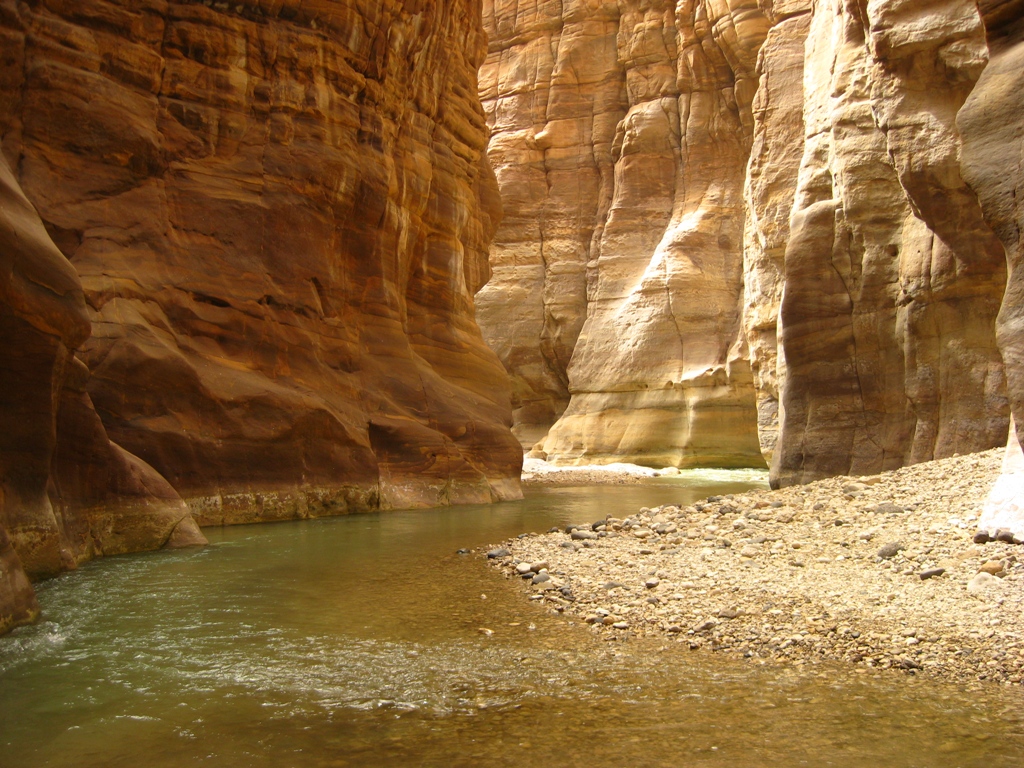
The Wadi Mujib (Arabic: وادي الموجب, romanized: Wādī al-Mūjib), known in Hebrew as Arnon (ארנון), is a river in Jordan. The river empties into the Dead Sea circa 420 metres (1,380 ft) below sea level.
In ancient times, the river served as the northern boundary of the kingdom of Moab.
Today, the Wadi Mujib is fed by seven tributaries. The western part of the river is the site of the Mujib Biosphere Reserve, popular for hikes and canyoning amid dramatic rock formations.
During the last ice age the water level of the Dead Sea reached 180 metres (590 ft) below sea level, about 240 metres (790 ft) higher than it is today. It flooded the lower areas of the canyons along its banks, which became bays and begun to accumulate sediments. As the climatic conditions changed, about 20,000 years ago,[citation needed] the water level of the lake dropped, leaving the re-emergent canyons blocked with lake marl. Most canyons managed to cut through their plugged outlets and to resume their lower courses; but Wadi Mujib abandoned its former outlet by breaking through a cleft in the sandstone. This narrow cleft became the bottleneck of an enormous drainage basin of 6,571 km2 (2,537 sq mi) with a huge discharge and annual sediment yield of 143,780 tonnes.[citation needed] During the years the cleft was scoured deeper and the gorge of Wadi Mujib was formed.
The Mujib Dam was completed in 2004 at the bottom of the wadi, where the modern road crosses the river. As a result, a large lake has formed.
The Mujib Reserve of Wadi Mujib is located in the mountainous landscape to the east of the Dead Sea, in the southern part of Jordan valley, approximately 90 kilometres (56 mi) south of Amman. A 212 km2 (82 sq mi) reserve was created in 1987 by the Royal Society for the Conservation of Nature and is regionally and internationally important, particularly for the bird life that the reserve supports. In 2011, UNESCO declared Mujib biosphere reserve. It extends to the Kerak and Madaba mountains to the north and south, reaching 1,277 metres (4,190 ft) above sea level in some places. This 1,708-metre (5,604 ft) variation in elevation of its drainage basin,[citation needed] combined with the valley's year round water flow from seven tributaries, means that Wadi Mujib enjoys magnificent biodiversity that is still being explored and documented. The reserve consists of mountainous, rocky, and sparsely vegetated desert (up to 800 metres (2,600 ft)), with cliffs and gorges cutting through plateaus. Perennial, spring-fed streams flow to the shores of the Dead Sea.
Over 300 species of plants, 10 species of carnivores and numerous species of permanent and migratory birds have been recorded. Some of the remote mountain and valley areas are difficult to reach, and thus offer safe haven for rare species of cats, goats and other mountain animals.
The slopes of the mountainous land are very sparsely vegetated, with a steppe-type vegetation on plateaus. Groundwater seepage does occur in places along the Dead Sea shore, for example at the hot springs of Zara, which support a luxuriant thicket of Acacia, Tamarix, Phoenix and Nerium, and a small marsh. The less severe slopes of the reserve are used by pastoralists for the grazing of sheep and goats.
Hub AI
Wadi Mujib AI simulator
(@Wadi Mujib_simulator)
Wadi Mujib
The Wadi Mujib (Arabic: وادي الموجب, romanized: Wādī al-Mūjib), known in Hebrew as Arnon (ארנון), is a river in Jordan. The river empties into the Dead Sea circa 420 metres (1,380 ft) below sea level.
In ancient times, the river served as the northern boundary of the kingdom of Moab.
Today, the Wadi Mujib is fed by seven tributaries. The western part of the river is the site of the Mujib Biosphere Reserve, popular for hikes and canyoning amid dramatic rock formations.
During the last ice age the water level of the Dead Sea reached 180 metres (590 ft) below sea level, about 240 metres (790 ft) higher than it is today. It flooded the lower areas of the canyons along its banks, which became bays and begun to accumulate sediments. As the climatic conditions changed, about 20,000 years ago,[citation needed] the water level of the lake dropped, leaving the re-emergent canyons blocked with lake marl. Most canyons managed to cut through their plugged outlets and to resume their lower courses; but Wadi Mujib abandoned its former outlet by breaking through a cleft in the sandstone. This narrow cleft became the bottleneck of an enormous drainage basin of 6,571 km2 (2,537 sq mi) with a huge discharge and annual sediment yield of 143,780 tonnes.[citation needed] During the years the cleft was scoured deeper and the gorge of Wadi Mujib was formed.
The Mujib Dam was completed in 2004 at the bottom of the wadi, where the modern road crosses the river. As a result, a large lake has formed.
The Mujib Reserve of Wadi Mujib is located in the mountainous landscape to the east of the Dead Sea, in the southern part of Jordan valley, approximately 90 kilometres (56 mi) south of Amman. A 212 km2 (82 sq mi) reserve was created in 1987 by the Royal Society for the Conservation of Nature and is regionally and internationally important, particularly for the bird life that the reserve supports. In 2011, UNESCO declared Mujib biosphere reserve. It extends to the Kerak and Madaba mountains to the north and south, reaching 1,277 metres (4,190 ft) above sea level in some places. This 1,708-metre (5,604 ft) variation in elevation of its drainage basin,[citation needed] combined with the valley's year round water flow from seven tributaries, means that Wadi Mujib enjoys magnificent biodiversity that is still being explored and documented. The reserve consists of mountainous, rocky, and sparsely vegetated desert (up to 800 metres (2,600 ft)), with cliffs and gorges cutting through plateaus. Perennial, spring-fed streams flow to the shores of the Dead Sea.
Over 300 species of plants, 10 species of carnivores and numerous species of permanent and migratory birds have been recorded. Some of the remote mountain and valley areas are difficult to reach, and thus offer safe haven for rare species of cats, goats and other mountain animals.
The slopes of the mountainous land are very sparsely vegetated, with a steppe-type vegetation on plateaus. Groundwater seepage does occur in places along the Dead Sea shore, for example at the hot springs of Zara, which support a luxuriant thicket of Acacia, Tamarix, Phoenix and Nerium, and a small marsh. The less severe slopes of the reserve are used by pastoralists for the grazing of sheep and goats.
Recent media