.jpg/250px-Nisa,_Turkmenistan_(3134901318).jpg "Walk of Health")
.jpg/2000px-Nisa,_Turkmenistan_(3134901318).jpg)
Community hub
Recent from talks
Contribute something
Nothing was collected or created yet.
Walk of Health
View on Wikipedia| Walk of Health | |
|---|---|
.jpg) View of the Walk of Health, 2008 | |
 | |
| Length | 36 km (22 mi) |
| Location | Ashgabat, Turkmenistan |
| Established | 2 January 2000 |
| Began construction | 1999 |
| Completed | mid-2000 |
| Use | Hiking |
| Highest point | 1,293 m (4,242 ft) |
| Lowest point | 228 m (748 ft) |
| Surface | Concrete |
| Maintained by | Government of Turkmenistan |
The Walk of Health (Turkmen: Saglyk ýoly, lit. 'health trail')[1] is a 36-kilometre (22 mi)[2][a] long concrete walkway that runs alongside the Kopet Dag mountain range in south Ashgabat, Turkmenistan, near the Iran–Turkmenistan border.[4] The first 8 km (5.0 mi) of the path was constructed in 1999 by dictator Saparmurat Niyazov, with the intent of encouraging citizens to be healthy. It officially opened on 2 January 2000.[5] Until Niyazov's death, he required his ministers to walk the walkway once every year.[3]
History
[edit]The first 8 km (5.0 mi) of the Walk of Health was constructed in 1999 by dictator Saparmurat Niyazov. It officially opened on 2 January 2000.[5] Niyazov made his ministers walk the walkway whilst he travelled by helicopter to meet them at the end of the walkway.[3][6] He feared that his own heart condition would render him unable to walk the entire length.[5] The walkway was expanded an additional 26 km (16 mi) in mid-2000, after which Niyazov announced he would require his ministers to walk the walkway once every year.[7] On 30 August 2004, over 10,000 people walked the walkway, including members of the government.[8] In July 2012, President of Turkmenistan Gurbanguly Berdimuhamedov expressed dissatisfaction with the state of the walkway. He said that the government would look for private investors to maintain it.[9]
Route
[edit]The concrete walkway is split into two sections: Leader's Trail, which is 8 km (5.0 mi),[5] and Serdar Trail, which is 28 km (17 mi).[10] The beginning of the Walk of Health is marked by an archway in Serdar Health Park. From their starting points, Leader's Trail runs northwest, terminating at the Kopetdag Highway south of Nisa, while Serdar Trail runs generally southeast, terminating at the Government Tribune complex on Gokdepe Highway south of Ashgabat. As there are no trees in the mountain range to provide shade, the walkway is difficult to walk in its entirety. It is accompanied by metal fences on either side of the path, as well as street lamps so that it can be illuminated at night. Numerous statues and sculptures line the walkway, with pavilions every kilometer for resting. The highest point of the walkway reaches 1,293-metre (4,242 ft), which is marked by a flagpole displaying the flag of Turkmenistan.[11][12]
Park
[edit]On May 17, 2024, near the Walk of Health, the cultural and park complex Magtymguly Pyragy and a monument dedicated to Magtymguly Pyragy were inaugurated, commemorating the 300th anniversary of the poet's birth. The park complex is located in the southern part of Ashgabat, near the Walk of Health, with its centerpiece being the monument to Magtymguly Pyragy.[13][14]
The bronze statue stands 60 metres (200 ft) tall, with a pedestal diameter of 25 metres (82 ft). Surrounding the monument are bronze sculptures of several renowned foreign literary figures and notable individuals, each standing 3.5 metres (11 ft) tall.[15]
The complex highlights the significance of literary and cultural heritage, serving as a place for reflection and appreciation.[16]
Gallery
[edit]-
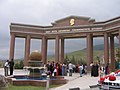 Archway at the entrance to the walkway
 -
 View of the walkway
 -
 Another view of the walkway


.JPG)
References
[edit]- ^ Esenow, Annageldi (2003). Saparmurat Türkmenbaşynyň beýik döwri arhitekturasy [Architecture of Saparmurat Turkmenbashi the Great epoch] (in Turkmen). Ruh. p. 501. Archived from the original on 2022-04-09. Retrieved 2022-03-25.
- ^ "13-ю годовщину избрания президента в Туркменистане ознаменовали массовым восхождением в горы" [13th anniversary of the election of the Turkmenistan President was marked by a mass climb in the mountains]. Turkmenistan.ru (in Russian). 20 June 2005. Archived from the original on 25 March 2022. Retrieved 25 March 2022.
- ^ a b c Morton, Ella (6 February 2014). "Golden Statues and Mother Bread: The Bizarre Legacy of Turkmenistan's Former Dictator". Slate. Archived from the original on 25 March 2022. Retrieved 25 March 2022.
- ^ Lonely Planet Blue List: The Best in Travel 2007. Lonely Planet Publications. 2006. p. 197. ISBN 978-1-74104-735-6. Archived from the original on 9 April 2022. Retrieved 25 March 2022.
- ^ a b c d "Туркменбаши поведет 'тропой здоровья'" [Turkmenbashi will lead the 'path of health']. Turkmenistan.ru (in Russian). 11 March 2000. Archived from the original on 25 March 2022. Retrieved 25 March 2022.
- ^ Walker, Shaun (25 May 2015). "A horse, a horse … Turkmenistan president honours himself with statue". The Guardian. Archived from the original on 11 June 2015. Retrieved 25 March 2022.
- ^ "Сапармурат ниязов решил превратить ашхабад в город-парк" [Saparmurat Niyazov decided to turn Ashgabat into a park city]. Turkmenistan.ru (in Russian). 17 April 2001. Archived from the original on 27 March 2022. Retrieved 27 March 2022.
- ^ "Более 10 тысяч туркменистанцев прошли по "тропе здоровья" в горах копетдага" [More than 10,000 Turkmenistanis walked the "health trail" in the Kopetdag mountains]. Turkmenistan.ru (in Russian). 30 August 2004. Archived from the original on 4 March 2016. Retrieved 27 March 2022.
- ^ "Президент Туркменистана предложил передать Тропу здоровья частным предпринимателям" [The President of Turkmenistan proposed to transfer the Health Path to private entrepreneurs]. Turkmenistan.ru (in Russian). 12 July 2012. Archived from the original on 4 March 2016. Retrieved 25 March 2022.
- ^ Lonely Planet Central Asia (4 ed.). Lonely Planet Publications. July 2007. p. 441.
- ^ Luckow, Beate (2019). Reiseführer Turkmenistan: Durch die Wüste Karakum nach Ashgabat, Nisa, Merw und Konya Urgench (in German). Trescher Verlag. p. 115. ISBN 978-3-89794-415-2. Archived from the original on 9 April 2022. Retrieved 25 March 2022.
- ^ "Туркменистанцы совершили массовое восхождение по Тропе здоровья" [Turkmen citizens made a mass ascent along the Path of Health]. Turkmenistan.ru (in Russian). 30 December 2010. Archived from the original on 25 March 2022. Retrieved 25 March 2022.
- ^ [1]
- ^ [2]
- ^ [3]
- ^ [4]