Hubbry Logo
Wallops IslandWallops IslandMain
Open search
Wallops Island
Community hub
Wallops Island
logo
8 pages, 0 posts
0 subscribers
Be the first to start a discussion here.
Wallops Island
Wallops Island
from Wikipedia

NASA Wallops Flight Facility

Key Information

Wallops Island is a six-square-mile (16 km2) island in Accomack County, Virginia, part of the Virginia Barrier Islands that stretch along the eastern seaboard of the United States.[1] It is just south of Chincoteague Island, a popular tourist destination.

Wallops Island proper, originally known as Kegotank Island, was granted to John Wallop by the Crown on April 29, 1692. Ownership was divided through the years, until the Commonwealth of Virginia seized the property in 1876 and 1877 in lieu of unpaid taxes. From 1877, ownership was again divided and subdivided until 1889, when it was held by various trustees for the Wallops Island Club. The club was incorporated and assumed ownership in 1933 as the Wallops Island Association, Inc. Association members and their families spent the summers fishing and swimming on the island. The Association grazed sheep, cattle, and ponies on the area until the mid-1940s. In 1947, the U.S. Navy began using the upper two-thirds of the island on a lease-rental basis for aviation ordnance testing. The National Advisory Committee for Aeronautics (NACA), forerunner of NASA, leased the lower 1,000 acres (4.0 km2) for rocket launching facilities.[2]

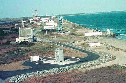
The island is used primarily for the Wallops Flight Facility, including the Mid-Atlantic Regional Spaceport, although the name also refers to the peninsula area surrounding the island for the purpose of mailing addresses. The Wallops Island National Wildlife Refuge and the Chincoteague Bay Field Station are located on the island.

Some of the World War II film Our Father was filmed on Wallops Island.

Climate

[edit]
Climate data for Wallops Island, 1991–2020 normals, extremes 1966–present
Month Jan Feb Mar Apr May Jun Jul Aug Sep Oct Nov Dec Year
Record high °F (°C) 79
(26)
79
(26)
86
(30)
93
(34)
97
(36)
100
(38)
102
(39)
100
(38)
96
(36)
93
(34)
82
(28)
78
(26)
102
(39)
Mean maximum °F (°C) 65.9
(18.8)
67.5
(19.7)
74.7
(23.7)
82.4
(28.0)
88.2
(31.2)
93.1
(33.9)
95.5
(35.3)
93.1
(33.9)
89.5
(31.9)
83.2
(28.4)
73.8
(23.2)
67.7
(19.8)
96.4
(35.8)
Mean daily maximum °F (°C) 46.2
(7.9)
48.5
(9.2)
54.5
(12.5)
64.3
(17.9)
72.7
(22.6)
81.3
(27.4)
86.1
(30.1)
84.2
(29.0)
78.7
(25.9)
69.1
(20.6)
58.8
(14.9)
50.5
(10.3)
66.2
(19.0)
Daily mean °F (°C) 37.9
(3.3)
39.8
(4.3)
45.8
(7.7)
55.1
(12.8)
64.1
(17.8)
73.2
(22.9)
78.2
(25.7)
76.5
(24.7)
70.8
(21.6)
60.2
(15.7)
49.7
(9.8)
42.0
(5.6)
57.8
(14.3)
Mean daily minimum °F (°C) 29.5
(−1.4)
31.1
(−0.5)
37.0
(2.8)
45.9
(7.7)
55.5
(13.1)
65.1
(18.4)
70.4
(21.3)
68.7
(20.4)
63.0
(17.2)
51.4
(10.8)
40.7
(4.8)
33.5
(0.8)
49.3
(9.6)
Mean minimum °F (°C) 12.3
(−10.9)
16.6
(−8.6)
22.4
(−5.3)
32.1
(0.1)
42.4
(5.8)
52.4
(11.3)
60.5
(15.8)
59.2
(15.1)
49.6
(9.8)
36.0
(2.2)
25.9
(−3.4)
19.3
(−7.1)
9.9
(−12.3)
Record low °F (°C) 0
(−18)
−1
(−18)
14
(−10)
26
(−3)
33
(1)
43
(6)
53
(12)
48
(9)
43
(6)
29
(−2)
19
(−7)
4
(−16)
−1
(−18)
Average precipitation inches (mm) 3.15
(80)
2.81
(71)
3.91
(99)
3.12
(79)
3.20
(81)
3.39
(86)
4.37
(111)
4.32
(110)
4.33
(110)
4.02
(102)
2.88
(73)
3.75
(95)
43.25
(1,099)
Average snowfall inches (cm) 3.5
(8.9)
2.3
(5.8)
0.7
(1.8)
0.2
(0.51)
0.0
(0.0)
0.0
(0.0)
0.0
(0.0)
0.0
(0.0)
0.0
(0.0)
0.0
(0.0)
0.0
(0.0)
1.7
(4.3)
8.4
(21)
Average precipitation days (≥ 0.01 in) 10.8 9.4 10.9 10.5 11.0 10.1 10.7 9.0 8.4 8.4 8.7 10.5 118.3
Average snowy days (≥ 0.1 in) 2.0 1.4 0.8 0.1 0.0 0.0 0.0 0.0 0.0 0.0 0.0 0.7 4.9
Source: NOAA[3]

References

[edit]
Revisions and contributorsEdit on WikipediaRead on Wikipedia
from Grokipedia
Wallops Island is a barrier island located along the Atlantic coast of Accomack County, Virginia, in the United States, forming part of the Delmarva Peninsula's Eastern Shore. Approximately 6 square miles (16 km²) in area, it lies just south of Chincoteague Island and is connected to the mainland via a 2-mile (3 km) causeway and bridge. The island is predominantly known as the site of NASA's Wallops Flight Facility, a critical hub for aerospace research, suborbital and small orbital rocket launches, and scientific missions supporting government, commercial, and international partners. Established in 1945 by the (NACA), the predecessor to , Wallops Island was initially developed as a test range for guided missile research at subsonic speeds, with the first rocket launches occurring on June 27, 1945, to evaluate radar systems. The facility expanded significantly after 's formation in 1958, incorporating a U.S. Navy air station in 1959 and evolving into a multi-mission center under the , renamed in 1981. Today, it encompasses over 4,200 acres on the island itself as part of a larger 6,500-acre complex, providing low-cost launch services for sounding rockets, balloons, unmanned aerial systems, and satellites, while facilitating environmental monitoring and military operations. In addition to its aerospace prominence, Wallops Island hosts the Wallops Island , a 373-acre established in 1975 to conserve salt marshes, woodlands, and shrublands that support diverse , , and amid the region's dynamic coastal . The island's geography features dunes, maritime forests, and tidal wetlands, which are integral to local and coastal resilience efforts.

Geography

Location and Physical Description

Wallops Island is situated in , at approximately 37°51′N 75°28′W, forming part of the chain that extends along the Atlantic coast of the . This location places it on the , within the broader physiographic province. The island spans approximately 5 square miles (13 km²) and functions as a , isolated from the mainland by Chincoteague Bay to the west while lying adjacent to Chincoteague Island to the north. Access to the mainland occurs via Wallops Island Road, a bridge spanning the bay and connecting to the nearby community of Wattsville. These boundaries contribute to its role as a dynamic coastal feature, supporting various federal facilities including launch sites. Topographically, Wallops Island is low-lying, with most elevations ranging from to under 10 feet (3 meters) above mean , though dunes can reach up to 10 to 20 feet (3 to 6 meters). It features a of sandy beaches, vegetated dunes, expansive salt marshes, and scattered maritime forests, characteristic of systems. The island's beaches experience significant , retreating at rates of 10 to 22 feet (3 to 7 meters) per year due to wave action, storms, and rising sea levels.

Climate

Wallops Island features a classified as Cfa under the Köppen system, characterized by hot, humid summers and mild winters influenced by its coastal location along the Atlantic Ocean. Based on 1991–2020 normals from the , the average annual temperature is 57.8°F (14.3°C), with daily highs averaging 66°F (19°C) and lows 49°F (9°C). Annual precipitation totals average 43.25 inches (1,099 mm), distributed fairly evenly but peaking in summer months such as August, when monthly rainfall often exceeds 4 inches (102 mm); this pattern is amplified by occasional Atlantic hurricanes and tropical storms that bring heavy rain and wind to the . Temperature extremes at the Wallops Island Airport station, operational since 1966, include a record high of 102°F (39°C) on July 7, 2012, and a record low of -1°F (-18°C) on January 21, 1985. Seasonal patterns reflect the subtropical regime, with mild winters featuring average January highs near 46°F (8°C) and lows around 30°F (-1°C), transitioning to warm, humid summers where July highs reach 85°F (29°C) and lows 71°F (22°C); average annual snowfall remains minimal at under 5 inches (127 mm), typically confined to brief events in winter.

History

Colonial and Early Settlement

Wallops Island, originally known as Kegotank Island, was granted to John Wallop by the British Crown on April 29, 1692, marking the beginning of European land ownership on the off the coast of . The grant reflected colonial expansion efforts in the region, where Wallop, an English settler, established initial claims that would shape the island's nomenclature and tenure for centuries. Ownership of the island fragmented over subsequent generations through inheritance and sales, leading to multiple private holdings by the . In 1876 and 1877, the Commonwealth of seized the property due to unpaid taxes, after which it remained largely undeveloped, used sporadically for grazing and minimal agriculture by local residents. By the early , interest in the island shifted toward recreational purposes, culminating in the formation of the Wallops Island Association in 1933, which incorporated as a private club for local families. Members utilized the island for seasonal activities, including , , crabbing, and beach outings, maintaining simple cabins and access paths until the mid-1940s. Concurrently, federal involvement began with the construction of the Wallops Beach Lifeboat Station and an adjacent in 1936 by the U.S. , aimed at enhancing coastal rescue operations along the treacherous Atlantic shoreline. This era of private recreation and limited public infrastructure transitioned in the as the island attracted military interest for testing activities.

Modern Development and NASA Establishment

Following , the U.S. expanded its presence on Wallops Island through the Chincoteague , utilizing the northern portion for aviation ordnance testing under the , which was established there in 1946. In coordination with these military activities, the (NACA), 's predecessor, leased approximately 1,000 acres on the southern end of the island starting May 11, 1945, to establish a dedicated site for pilotless aircraft and . This arrangement was formalized in 1947, when the granted NACA access to additional areas for experimental , marking the island's shift from private hunting grounds to a hub for aeronautical innovation. The site, initially known as the Auxiliary , was redesignated the Pilotless Aircraft in 1946, focusing on unmanned launches over the Atlantic Ocean to study and . With the on October 1, 1958, the facility transitioned from NACA oversight to become an independent entity, renamed Wallops Station in 1959 to reflect its growing role in space exploration. During the early era, Wallops Station played a pivotal role in , conducting unmanned tests of Mercury spacecraft capsules from 1959 to 1961 using Little Joe rockets to evaluate the under simulated abort conditions. A landmark achievement came on February 16, 1961, when the facility launched Explorer IX, the first U.S. deployed by an all-solid-propellant orbital , advancing atmospheric density measurements for future missions. The facility underwent further evolution, renamed Wallops Flight Center in 1974 to emphasize its expanded launch capabilities, and then Wallops Flight Facility in 1981 upon integration with NASA's . Since its inaugural rocket launch on June 27, 1945, Wallops has supported over 16,000 launches, establishing it as one of the world's most active suborbital and small orbital test ranges. In recent decades, the site has broadened its scope to accommodate commercial and international missions, providing launch services for private entities like and , as well as collaborative international projects, while maintaining its core focus on agile, cost-effective testing.

Facilities

Wallops Flight Facility

The Wallops Flight Facility (WFF), operated by NASA's Goddard Space Flight Center, serves as a premier launch range and research airport dedicated to suborbital and small orbital missions. Established in 1945 by the National Advisory Committee for Aeronautics (NACA) as the Pilotless Aircraft Research Station, it was renamed Wallops Flight Facility in 1981 and spans more than 6,000 acres across three parcels: Wallops Island, the Main Base, and the Mainland complex. This infrastructure supports a wide array of research activities, including sounding rockets, scientific balloons, and research aircraft, enabling low-cost access to space for scientific exploration and technology development. Key infrastructure at WFF includes six launch pads designated for suborbital and small orbital vehicles, such as Pads 0A, 0B, 1, 2, and 3B, which facilitate diverse configurations. The facility features three runways for research and unmanned aerial systems (UAS), measuring 8,005 ft x 200 ft, 8,750 ft x 150 ft, and 4,810 ft x 150 ft, along with a dedicated 1,500 ft x 50 ft for UAS operations. Tracking capabilities are enhanced by precision tracking radars like the RIR-716C and mobile units for real-time data collection. Additionally, mobile range assets, including , command/control systems, and recovery equipment such as UH-1 Huey helicopters, enable global deployments for missions in remote locations. As a multi-user site, WFF collaborates with partners including the (NOAA), (FAA), and U.S. Navy to provide agile launch services focused on low-cost access to . Operations emphasize suborbital platforms for atmospheric and , high-altitude balloons for extended-duration studies, and UAS for , supporting sectors in , defense, and technology. The facility manages these activities through contracts like the Operations Contract (NSROC), ensuring flexible and cost-effective mission execution for government and select commercial users. Historically, WFF's first research mission was the launch of the missile on July 4, 1945, following an initial test rocket on June 27, 1945, marking the site's origins in and missile testing during the post-World War II era. Since then, it has conducted thousands of launches, contributing to advancements in areas such as Project Mercury's Little Joe booster tests in the late 1950s and ongoing suborbital research for defense and scientific applications. These missions underscore WFF's enduring role in fostering innovation through reliable, ground-based testing and flight experimentation.

Mid-Atlantic Regional Spaceport

The (MARS) is a commercial facility owned and operated by the Virginia Spaceport Authority, a political subdivision of the Commonwealth of Virginia established in 1995 by the as the Virginia Commercial Space Flight Authority. Located at the southern tip of NASA's on Wallops Island, MARS functions as a tenant organization, leveraging shared infrastructure while focusing on commercial orbital launch services. It supports vertical launches to orbital trajectories with inclinations ranging from 38° to 60°, accommodating small- and mid-class rockets for missions including sun-synchronous orbits. MARS has hosted a variety of launch vehicles, including Northrop Grumman's Antares from Pad 0A, the Minotaur I, IV, and V series from Pad 0B, and Rocket Lab's Electron from Pad 0C (also known as Launch Complex 2). The site's first orbital launch attempt occurred in 1995 with the Conestoga rocket from Pad 0A, marking the inaugural use of MARS infrastructure, though it ended in failure shortly after liftoff. Since then, the spaceport has supported over 40 missions, with notable examples including Rocket Lab's Electron "Virginia is for Launch Lovers" mission on January 24, 2023, which successfully deployed three HawkEye 360 satellites into orbit, a follow-on Electron launch on March 21, 2024, and a second successful Rocket Lab mission completed as of October 2025. Pad 0C, developed in partnership with Rocket Lab and opened in 2019, serves as a universal launch complex adaptable for small-class vehicles, enabling frequent commercial operations. Infrastructure at MARS includes dedicated commercial facilities such as the Integration and Control Facility, Payload Processing Facility, and MARS Command Building, alongside a 3,000-foot by 75-foot unmanned aircraft systems airfield for support operations. While sharing and services with , these assets are primarily allocated to private partners to facilitate payload integration and mission preparation. The contributes significantly to regional as part of the Wallops Island Cluster, generating an estimated $1.5 billion in direct economic impact for in 2023 and supporting 3,300 to 4,600 jobs annually through activities. This development underscores MARS's role in fostering innovation and job creation in the commercial .

National Wildlife Refuge

The Wallops Island was established on July 10, 1975, through the transfer of 373 acres (1.51 km²) of land from the () to the U.S. Fish and Wildlife Service (USFWS), pursuant to the Migratory Bird Conservation Act and related authorities for creating an inviolate sanctuary for migratory birds. This action stemmed from a 1971 agreement between and the Bureau of Sport Fisheries and Wildlife (predecessor to USFWS), which initially provided for nonexclusive use of approximately 3,000 acres of adjacent lands for conservation purposes, renewed periodically until 2006. The refuge's creation balanced wildlife protection with ongoing operations at the nearby , ensuring habitat preservation amid space launch activities. Encompassing 373 acres on the southern portion of Wallops Island in , the refuge lies between Virginia State Route 175 and Chincoteague Bay, featuring a mix of , woodlands, and early successional habitats. It is closed to general public access to protect sensitive ecosystems, with entry restricted to permitted activities only; non-motorized access is allowed where feasible, but no facilities like trails or visitor centers exist within its boundaries. The sole exception is controlled , authorized starting in 2002 via a lottery system to manage overbrowsing and deer-vehicle collisions, limited to 25 participants annually during mid-November to early , with firearms prohibited and capped to sustain habitat health—yielding about 11 deer in recent seasons. Its proximity to launch sites enables public observation of rocket launches from adjacent beaches outside the refuge. Administered as an unstaffed satellite unit of the Chincoteague complex by USFWS, the refuge receives approximately 30 staff-days per year for oversight, primarily focused on hunt management, with proposals for a dedicated Refuge Specialist position. Coordination with occurs through agreements like the 2011 for shared monitoring and radio infrastructure, while a power line right-of-way traversing 57 acres is maintained by A&N through vegetation control, fostering early successional habitats by removing such as autumn . A distinctive ecological highlight is the "Lucky Boy" fen, a rare sea-level seepage under 0.5 acres in size—one of only four known in and among five on the East Coast—supporting six globally or state-rare plant species at their southern range limits, including critically imperiled brown-fruited rush (Juncus pelocarpus) and few-flowered beakrush (Rhynchospora fascicularis). This nutrient-poor, maritime feature, situated just above high tide levels, underscores the refuge's role in conserving unique coastal amid threats like sea-level rise and changes.

Ecology and Conservation

Habitats and Biodiversity

Wallops Island, a barrier island in Accomack County, Virginia, features a range of coastal habitats adapted to dynamic environmental conditions, including dune systems that stabilize the shoreline and provide nesting grounds for shorebirds, maritime forests dominated by species like loblolly pine and black cherry in xeric areas, and extensive salt marshes that serve as critical buffers against erosion and storm surges. The island's ecosystems encompass approximately 3,340 acres of tidal wetlands, representing about 4.7% of Accomack County's total tidal wetlands, which span approximately 70,000 acres countywide. The mainland portions of the Wallops Flight Facility, adjacent to the island, support complementary inland habitats such as swamps and palustrine wetlands, dense thickets of scrub-shrub vegetation, upland grasslands used for managed wildlife areas, and mixed forests including hardwood and pine stands that enhance habitat connectivity. These diverse ecosystems collectively form a mosaic that facilitates nutrient cycling and sediment deposition, vital for the barrier island's long-term resilience. A unique feature is the rare sea-level fen, known as Lucky Boy Fen, a globally significant (G1-ranked) wetland less than 0.5 acres in size that supports six rare plant species and acts as a groundwater recharge area. Biodiversity on Wallops Island is particularly rich in avian species, serving as a key stopover along the Atlantic Flyway and supporting over 300 migratory birds during peak seasons, including raptors like northern harriers and bald eagles, as well as great horned owls that inhabit forested edges. Threatened and endangered species, protected under the Endangered Species Act (ESA), Migratory Bird Treaty Act (MBTA), and Virginia Endangered Species Act, include the piping plover, a federally and state-listed shorebird that nests on dunes with 74 nests recorded between 2007 and 2022. Marine life thrives in surrounding waters, with marine mammals such as bottlenose dolphins, harbor seals, and occasional humpback whales utilizing the area, alongside sea turtles including loggerhead, leatherback, green, and Kemp's ridley species that nest on beaches. Terrestrial biodiversity features white-tailed deer populations, which are common across habitats and managed to prevent overbrowsing.

Environmental Management

NASA's Wallops Flight Facility implements annual beach closures on portions of Wallops Island from mid-March to early fall in collaboration with the U.S. Fish and Wildlife Service to protect nesting sites of the federally threatened piping plover. These closures restrict public access to sensitive coastal areas, allowing the species to breed undisturbed amid ongoing space launch activities. Additionally, post-launch monitoring protocols involve immediate beach surveys following rocket missions to assess and mitigate any potential impacts on wildlife, including birds, marine mammals, and sea turtles. Shoreline erosion poses a significant challenge to the island's environmental integrity, prompting NASA to undertake periodic sand replenishment projects as a primary mitigation strategy. For instance, the 2019 Shoreline Enhancement and Restoration Project involved placing approximately 1.1 million cubic yards of sand along the beach and constructing five offshore breakwaters to stabilize the coastline and reduce wave impacts. Sea-level rise further threatens the island's wetlands, exacerbating habitat loss through increased flooding and inundation, which disrupts salt marshes and migratory bird foraging areas. To ensure compliance with the Endangered Species Act, partners closely with the U.S. Fish and Wildlife Service and the Department of Wildlife Resources, integrating their expertise into operational planning to minimize disturbances to protected species. This includes mandatory training programs for personnel, with updated 2025 guidelines providing awareness and protocols for encountering during facility activities. Cultural preservation efforts at Wallops Island focus on maintaining historical sites integral to the area's heritage, such as the 1936 Wallops Beach Lifeboat Station and Observation Tower, which served as a U.S. Coast Guard rescue facility until 1947. Managed under NASA's Integrated Cultural Resource Management Plan, the station—eligible for listing on the —undergoes regular preservation to retain its architectural and historical integrity while coexisting with modern space operations.

References

Add your contribution
Related Hubs
User Avatar
No comments yet.