Hubbry Logo
Wellesley IslandWellesley IslandMain
Open search
Wellesley Island
Community hub
Wellesley Island
logo
8 pages, 0 posts
0 subscribers
Be the first to start a discussion here.
Wellesley Island
Wellesley Island
from Wikipedia

44°19′N 76°00′W / 44.317°N 76.000°W / 44.317; -76.000

Map of Wellesley Island

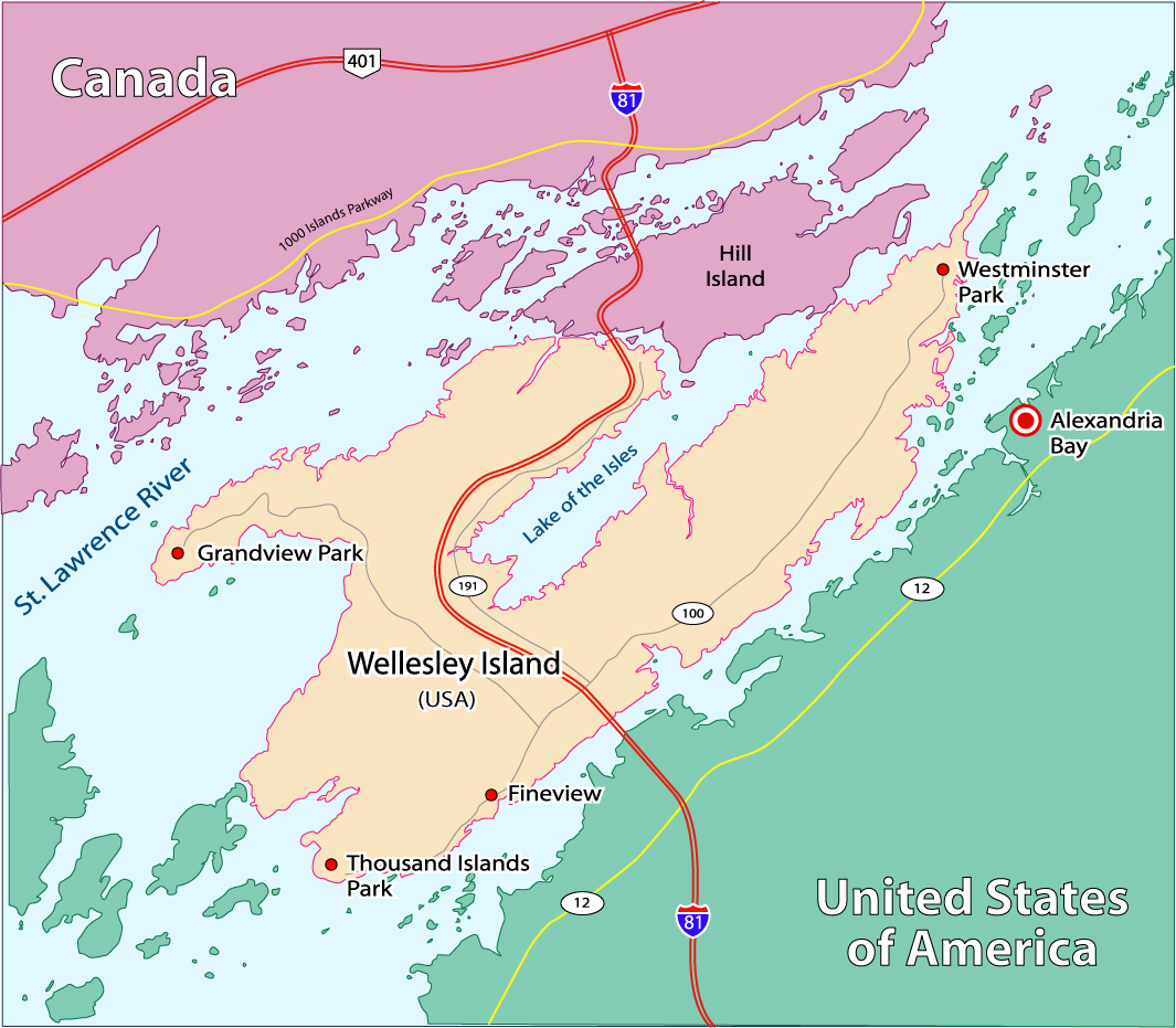
Wellesley Island is an island in Jefferson County, New York, the island is partially in the Town of Orleans and partially in the Town of Alexandria.

History

[edit]

The island was originally named Wells Island. During the 1815 survey of the US-Canada border by Captain William Fitzwilliam Owen, the island was renamed to its current name to honor Arthur Wellesley, 1st Duke of Wellington. Several prominent points in and around the island were named after the Duke's victorious battles. None of those names stuck. The large bay around which the island folds is called Lake of the Isles, not Lake Waterloo.[1]

Geography

[edit]

The island is located 44°19′N 76°00′W / 44.317°N 76.000°W / 44.317; -76.000 in the St. Lawrence River, which surrounds Wellesley Island on three sides. The island bounds an internal body of water, the Lake of the Isles, which nearly doubles its waterfront. The easternmost peninsula of the island lies across the Upper (American) Narrows from the Village of Alexandria Bay.

View of Dukeman's Island, located in the middle of Wellesley Island's interior Lake of the Isles

An arterial highway, Interstate 81, crosses Wellesley Island. Five segments composing the Thousand Islands International Bridge link the island to the opposite shores of the river. One of the bridges crosses a narrow channel, the International Rift, which separates Wellesley Island in the United States from Hill Island in the township of Leeds and the Thousand Islands, Ontario, Canada. The United States border-crossing facility at the port of entry is located on the northeastern part of the island.

Wellesley, one of the largest of the Thousand Islands in the St. Lawrence River. Population increases dramatically during the summer months. The island has two State Parks, a nature center, and three golf courses. Located on its southern tip is Thousand Island Park, listed on the National Register of Historic Places in 1982.[2] In addition to Interstate 81, which connects two portions of the Thousand Islands Bridge, Jefferson County Routes 100 and 191 serve the island.

Geographic features

[edit]
  • Barnett Marsh—A swamp in the south part of the island.
  • Densmore Bay—A bay on the south shore of the southeast peninsula.
  • Eel Bay—A large bay between Wellesley Island and Grindstone Island.
  • Lake of the Isles—A body of water connected to the St. Lawrence River, lying between the northeast and southeast peninsulas.
  • South Bay—A bay on the southwest part of the island.
Victorian homes typical of the Thousand Island Park community on the south west tip of Wellesley Island.

Communities on the island

[edit]

Parks on the island

[edit]

References

[edit]
Revisions and contributorsEdit on WikipediaRead on Wikipedia
from Grokipedia
Wellesley Island is an approximately 12-square-mile island in the , situated in , as part of the archipelago between the and . It lies partially within the Town of Orleans and partially within the Town of Alexandria, accessible via the Thousand Islands International Bridge system. The island features a year-round population of around 300 residents, though this number increases substantially during the summer tourist season due to its recreational amenities. Geologically, Wellesley Island is underlain by ancient rocks of the Grenville Province, dating back 1.1 to 1.3 billion years, part of the Canadian Shield and the Frontenac Arch—a that exposes metamorphic and outcrops visible along its shores and inland areas. These formations, shaped by tectonic events and later erosion from glacial activity at the end of the last Ice Age, contribute to the island's rugged terrain, including open exposures, wooded wetlands, and over three miles of shoreline along Eel Bay and other inlets. The landscape supports diverse ecosystems, such as the 380-acre Wellesley Island Preserve with its rich wetlands and forests, ideal for and . Historically, the island—originally known as Wells Island—was renamed Wellesley Island in 1815 by British Captain William Fitzwilliam Owen to honor Arthur Wellesley, the Duke of Wellington. In 1875, the northern portion became the site of , founded by the Rev. John Ferdinand Dayan as a Methodist campground meeting association, which rapidly developed into a Victorian-era community with cottages, hotels, and recreational facilities before facing decline from fires and economic shifts in the early . Around 1900, hotelier George C. Boldt established the Wellesley Island Farms and Wellesley House as a temporary residence for his family while constructing on nearby Heart Island, highlighting the area's early prominence in regional tourism. Today, the island hosts two state parks: the 2,636-acre Wellesley Island State Park, the largest camping complex in the with over 400 sites, a , , and the Minna Anthony Common Nature Center; and the smaller DeWolfe Point State Park, offering additional cabins and trails. These attractions, combined with opportunities for species like and muskie, make Wellesley Island a key destination for outdoor enthusiasts and a vital part of the U.S.- border region's cultural and .

History

Naming and Early History

The Thousand Islands region, including the area encompassing Wellesley Island, has been part of the traditional territory of the Haudenosaunee (also known as the Confederacy) and peoples for millennia, where they hunted, fished, and utilized the waterways for travel and trade. European exploration of the began in the early 17th century, with French explorer traversing the river in 1609 and 1615 during his voyages to the interior, establishing early French presence in the broader region through alliances with Indigenous groups and mapping efforts. Prior to formal British surveying, the island was known as Wells Island, a name likely originating from early colonial records but without a definitively documented tied to specific explorers or settlers. This designation appears in pre-1816 maps of the archipelago, reflecting informal naming practices amid the region's strategic importance along the U.S.- border. In 1816, following the , British naval officer Captain William Fitzwilliam Owen, a hydrographer with the Royal Navy who had served in various surveys including the , conducted a systematic charting of the to delineate the international boundary and improve navigation. Owen, born in 1774 and known for his meticulous cartographic work despite early hardships, renamed Wells Island as Wellesley Island to honor Arthur Wellesley, the 1st Duke of , a prominent British military leader celebrated for victories in the (1808–1814) and as a symbol of British resolve post-. The influenced Owen's naming scheme, which commemorated British naval and army officers from that conflict and related campaigns, though no temporary battle-specific names for this particular island are recorded in surviving documents; instead, the renaming contributed to a broader pattern honoring over 50 figures associated with in the vicinity. Owen's charts, completed with assistance from Lieutenants Alexander Vidal and Henry Bayfield and published in 1818, formalized these names and endured despite some local alterations over time.

Settlement and Development

European settlement on Wellesley Island began in the early 19th century following the island's inclusion in New York State territory after the War of 1812. In 1818, the island, then known as Wells Island, was patented to Colonel Elisha Camp of Sackets Harbor, who acted as agent for landholders and facilitated initial land distribution. Pioneer families, such as the Wells and Comstock families, established farms and homes starting in the 1820s; William Wells, an early settler in the Town of Clayton, contributed to the island's agricultural foundation, while William and Mary Comstock resided there by 1827, raising children amid modest log dwellings typical of the era. These early inhabitants focused on farming and self-sufficient living, marking the shift from indigenous use to permanent European occupancy. The late 19th century saw the rise of summer resorts and vacation communities, transforming parts of the island into seasonal retreats. In 1875, Rev. John Ferdinand Dayan founded as a Methodist campground on the island's northern end, promoting a Chautauqua-style environment with religious meetings, lectures, and recreational facilities; initial development included tent platforms and over 1,800 lots sold rapidly to attract families seeking healthful escapes. Hotelier George C. Boldt further spurred growth by developing extensive farms, a residence known as Wellesley House, and clusters of cottages on the island in the 1890s and early 1900s, enhancing its appeal as a luxury destination amid the burgeoning tourism boom in the region. The construction of the Thousand Islands International Bridge in 1938 dramatically improved accessibility, connecting Wellesley Island directly to the mainland and via spans over the ; this infrastructure, dedicated by U.S. President and Canadian Prime Minister , reduced travel barriers and facilitated automobile access, spurring population growth and year-round visitation. Throughout the 20th century, the island's resort areas faced challenges including devastating fires—such as the 1890 blaze that destroyed the Thousand Island Park Hotel and several cottages, and the 1912 Great Fire that razed numerous structures—and economic downturns, notably the 1933 foreclosure of the Thousand Island Park Association amid the , which led to property sales and a contraction in seasonal operations during the 1930s and 1940s. Recovery efforts culminated in 1982 when Thousand Island Park was listed on the , recognizing its intact Victorian-era architecture and aiding preservation amid renewed . Tourism has driven seasonal population surges on Wellesley Island since the , with summer visitors swelling numbers from a small permanent farming community to thousands of cottagers and day-trippers; this pattern persisted through the , bolstered by expansions and bridge connectivity, establishing the island as a enduring vacation hub.

Geography

Location and Boundaries

Wellesley Island is situated at approximately 44°19′N 76°00′W in , within the archipelago of the . The island spans portions of the Towns of and , placing it under the administrative jurisdiction of both municipalities. As one of the larger islands in this international chain of over 1,800 islands and islets, it occupies a central position in the river's navigation channel. The island's boundaries are defined primarily by the surrounding waters of the , which encircle it on multiple sides and form natural demarcation lines. To the north, it borders Hill Island in across the narrow International Rift, a critical segment of the U.S.-Canada international boundary where the river's flow separates the two nations. This rift highlights the island's role in the geopolitical dynamics of the border region, with the International Bridge spanning the divide to connect Wellesley Island directly to Canadian territory. Internally, the island encompasses Lake of the Isles, a semi-enclosed that connects to the broader St. Lawrence system. Wellesley Island lies in close proximity to mainland points, including the village of Alexandria Bay in the Town of , situated across the Upper American Narrows to the east. This positioning facilitates easy access from the U.S. mainland via the American span of the Thousand Islands International Bridge, which crosses the from Collins Landing near Alexandria Bay to the island.

Size and Topography

Wellesley Island covers an area of approximately 13 square miles (34 km²), positioning it as one of the larger islands within the archipelago of the . The island measures about 7 miles (11 km) in length, featuring an elongated form with a prominent southeast and an irregular shoreline characterized by numerous bays and inlets, such as South Bay and Densmore Bay. The of Wellesley Island is generally low-lying, with rolling hills and varied shaped by ancient geological processes and more recent glacial activity. The includes wooded peninsulas, outcrops, and glacier-polished ridges, reflecting the retreat of glaciers around 10,000 years ago that scoured the region and deposited sediments. The maximum reaches approximately 400 feet (122 m) above , as indicated by topographic surveys near the island's areas. Underlain by granitic of the Grenville Province with a thin veneer of and minor formations, often overlain by a thin veneer of glacial till and fluvial deposits, these rocks influence local drainage patterns—promoting features in areas and sandy, well-drained soils in sandstone-dominated zones—which in turn affect vegetation distribution across the rolling terrain.

Natural Features

Inland Waters and Marshes

Wellesley Island features several internal water bodies that contribute to its hydrological system. The Lake of the Isles, a shallow freshwater lake with a maximum depth of 15 feet, occupies the central interior of the island between its northeast and southeast peninsulas. Connected to the via narrow channels at its western end, the lake experiences limited water exchange, fostering extensive aquatic vegetation and serving as both a wildlife and a site for recreational use. Surrounding the island's perimeter are notable bays and inlets, including Eel Bay, a large embayment on the northeast side separating Wellesley Island from Grindstone Island; South Bay, located on the eastern shore; and Densmore Bay, situated on the south shore of the southeast peninsula. These features, shaped by the island's undulating , create sheltered coves that influence local water circulation. The island's wetlands, particularly in the southern region, form significant systems integral to its . Barnett Marsh, an approximately 150-acre streamside wetland southeast of the Lake of the Isles, is fed by Barnett Creek, which flows into the lake and supports a unique hydrological regime within a 1,300-acre embayment complex. This , part of the largest Class 1 wetlands complex in the region, maintains high water quality through natural filtration processes and provides essential buffering against hydrological fluctuations. These inland waters and marshes play a critical role in the island's by moderating flooding patterns, as their absorbent capacities help mitigate the impacts of level changes in this sheltered system. They enhance overall by trapping sediments and pollutants from runoff, while the limited connectivity to the river ensures stable, nutrient-rich flows that sustain the local aquatic environment.

Vegetation and Wildlife

Wellesley Island features mixed deciduous forests dominated by species such as red oak (Quercus rubra), sugar maple (Acer saccharum), and white pine (Pinus strobus), which form a mature canopy interspersed with hickories like shagbark hickory (Carya ovata). These forests cover much of the island's interior, supporting understory plants including spring ephemerals like trillium (Trillium spp.) and Jack-in-the-pulpit (Arisaema triphyllum). In wetland areas, such as those adjacent to marshes, vegetation shifts to emergent species like cattails (Typha spp.), sedges (Carex spp.), and buttonbush (Cephalanthus occidentalis), which stabilize shorelines and provide habitat structure. The island's wildlife is diverse, reflecting its position in the St. Lawrence River ecosystem, with common mammals including white-tailed deer (Odocoileus virginianus), raccoons (Procyon lotor), and beavers (Castor canadensis). Bird species abound, particularly raptors like bald eagles (Haliaeetus leucocephalus) and ospreys (Pandion haliaetus), which nest along the waterways, alongside shorebirds such as gulls, terns, and sandpipers during migration. In surrounding waters, fish populations include smallmouth bass (Micropterus dolomieu), walleye (Sander vitreus), and yellow perch (Perca flavescens), supporting both resident and seasonal aquatic life. Migratory birds utilize areas like Eel Bay as stopover habitats along the Atlantic Flyway, with species such as herons and waterfowl passing through in spring and fall. Ecologically, Wellesley Island contributes to the broader system, serving as a corridor for species movement within the Frontenac Arch and the Adirondacks-to-Algonquin () wildlife pathway. Conservation efforts, including habitat restoration by organizations like the and SLELO , focus on preserving forests and wetlands while addressing such as zebra mussels (Dreissena polymorpha) that threaten native . These initiatives, including over 3,500 native plantings in recent years, aim to enhance resilience against ecological pressures. The island experiences a , with average summer highs reaching 80°F (27°C) in and winters dropping below freezing, often to minima around 8°F (-13°C) in . This influences through vibrant fall foliage in trees and dormant periods in winter, while animal activity peaks in warmer months with breeding and foraging, and shifts to migration or in colder seasons.

Settlements and Infrastructure

Communities and Population

Wellesley Island's primary community is Thousand Island Park, a historic hamlet located on the eastern portion of the island within the Town of . Founded in 1875 as a Methodist campground by the Thousand Island Park Association, it features Victorian-era cottages and public buildings that reflect its origins as a Chautauqua-style retreat focused on religious, cultural, and recreational activities. The community is designated as a national historic district, preserving over 300 structures from the late 19th and early 20th centuries, including tent cottages, a , and a , which maintain its architectural and . The island's year-round population is approximately 300–350 (estimates via 13640), according to 2020 U.S. Census data, concentrated in scattered residential areas across the Towns of and , with no incorporated villages or formal municipalities. Thousand Island Park, a , accounts for a significant portion of this, with 96 permanent residents per the 2020 Census, though the overall figure includes other small clusters of homes. During the summer months, the population increases dramatically due to seasonal residents occupying the island's 855 housing units, many of which are vacation cottages, transforming it into a bustling tourist destination. Demographically, the island's residents are predominantly , comprising 97.67% of the , with a age of about 65, reflecting a dominated by retirees. The household income stands at $92,422, supporting an economy closely linked to , seasonal rentals, and living, with average household sizes of 1.83 indicating smaller, older family units. This seasonal variation underscores the island's social structure, where year-round inhabitants maintain essential services and ties, while summer influxes revitalize local traditions rooted in its Methodist heritage.

Transportation

Wellesley Island is primarily accessed via road infrastructure that integrates it into regional and international travel networks. (I-81) traverses the island, providing a major north-south corridor that connects the U.S. mainland to the Canadian border, with its northern terminus at the International Bridge. The International Bridge, a multi-span structure opened on August 18, 1938, links the island's northern end to Ivy Lea, , facilitating seamless vehicular passage across the and supporting over 2 million annual crossings for both passenger and commercial traffic. Local roadways on the island include Jefferson County Route 100, which serves as the primary east-west thoroughfare connecting residential areas, parks, and key facilities across the island's interior. Complementing this, County Route 191 branches off from I-81 Exit 51, offering access to southern sections of the island, including entry points to Wellesley Island State Park and nearby communities like Thousand Island Park. These routes ensure connectivity for residents and visitors while accommodating seasonal tourism demands. Water-based transportation is vital for navigation along the , with Wellesley Island State Park featuring a full-service and four dedicated launches that support recreational boating and access to surrounding waterways. The island lacks direct rail or air services, relying instead on these road and water options for mobility. As a key border crossing point, the includes U.S. Customs and Border Protection facilities at Collins Landing, handling inspections for international travelers and underscoring the island's role in U.S.- connectivity.

Recreation and Attractions

State Parks

Wellesley Island hosts two prominent state parks managed by the New York State Office of Parks, Recreation and Historic Preservation (NYS OPHP), which emphasize conservation of natural habitats and providing public access to recreational opportunities along the St. Lawrence River. Wellesley Island State Park was established in 1954, while DeWolfe Point State Park dates to 1898; together, these parks reflect the state's commitment to preserving the Thousand Islands region's biodiversity while accommodating growing visitor demands for outdoor activities. Wellesley Island State Park, spanning 2,636 acres, serves as the largest camping complex in the area and features a diverse array of facilities for year-round use. The park offers over 400 campsites, including wilderness sites along the riverbanks, along with 10 cabins and 12 cottages for rental, a full-service with dockage, a sandy swimming beach, extensive and multi-use trails suitable for and snowshoeing, and the Minna Anthony Common Nature Center for educational programs on local . Unique amenities include a 9-hole and dumping stations to support extended stays, all set within protected woodlands and wetlands that provide brief glimpses into the island's and forested habitats. DeWolfe Point State Park, a 13-acre facility on a of Wellesley Island overlooking Eel Bay and the Lake of the Isles, focuses on rustic accommodations and water access in a serene setting. It provides 15 non-electric campsites and 14 cabins for rental, a boat launch and dockage, areas, and trails through wooded areas, alongside opportunities for and boating. The park features a historic stone offering scenic views, enhancing its appeal for visitors seeking quiet retreats and family-friendly nature experiences.

Golf Courses and Nature Center

Wellesley Island features three courses that cater to both and private players, enhancing the island's appeal as a recreational destination. The Wellesley Island State Park Golf Course is a 9-hole facility established over 80 years ago, known for its rolling fairways, challenging approach shots through valleys shaped by the ' topography, a par of 35, and a length of 2,700 yards. The Thousand Islands Country Club, a semi-private club dating back to 1894, offers two 18-hole courses—the historic Old Course and the Lake Course—spanning 36 holes total, with practice facilities, a golf school, and scenic views of the . These courses, originating from the island's early 20th-century resort era, primarily serve seasonal residents and visitors during the summer months. The Minna Anthony Common Nature Center, situated within Wellesley Island State Park on 600 acres, serves as an educational hub focused on the ' ecology. The 3,500-square-foot facility houses family-friendly exhibits on local and habitats, including live animals, a discovery room with hands-on activities like books and games for children, and displays highlighting the region's diverse ecosystems. It offers year-round programs such as guided hikes, summer canoe trips, arts and crafts, a seasonal , winter rentals and , and educational sessions on environmental conservation. The center's 9 miles of trails traverse varied terrains, including Eel Bay shoreline, meadows, wetlands, forests, and cliffs, providing opportunities to observe local and like bald eagles in winter. Named after ecologist Minna Anthony Common, who documented the area's in the mid-20th century, the center was restored in 2018 to expand its exhibits and programming for schools and the public. These attractions play a key role in Wellesley Island's tourism economy, drawing summer visitors to the Thousand Islands region and supporting seasonal businesses through golf outings, nature programs, and related activities. Beyond the state parks, non-park options include hiking and birdwatching at the Wellesley Island Preserve, a Thousand Islands Land Trust site featuring the region's largest Class 1 wetlands complex for paddling and wildlife viewing. Fishing access points outside park management, such as private marinas and riverfront properties, provide additional spots for anglers targeting St. Lawrence River species.

References

Add your contribution
Related Hubs
User Avatar
No comments yet.