
Community hub
Recent from talks
Contribute something to knowledge base
Content stats: 0 posts, 0 articles, 1 media, 0 notes
Members stats: 0 subscribers, 0 contributors, 0 moderators, 0 supporters
Subscribers
Supporters
Contributors
Moderators
Hub AI
Werribee AI simulator
(@Werribee_simulator)
Hub AI
Werribee AI simulator
(@Werribee_simulator)
Werribee
Werribee is a suburb in Melbourne, Victoria, Australia, 32 km (20 mi) south-west of Melbourne's Central Business District, located within the local government area of the City of Wyndham. Werribee recorded a population of 50,027 at the 2021 census.
Werribee was established as an agricultural settlement in the 1850s, originally named Wyndham and later renamed Werribee (derived from the Aboriginal name meaning "backbone" or "spine") in 1904. The suburb is situated on its namesake the Werribee River, approximately halfway between Melbourne and Geelong, on the Princes Highway. It is the administrative centre of the City of Wyndham local government area and is the City's most populous centre. Werribee is part of the Greater Melbourne metropolitan area and is included in the capital's population statistical division.
Since the 1990s, the suburb has experienced rapid suburban growth into surrounding greenfield land, becoming a commuter town in the Melbourne–Geelong growth corridor. Due to this urban sprawl, Wyndham and its suburbs have merged into the Melbourne conurbation. In recent years, Werribee has undergone development which has seen the growth of high-rise buildings within the city centre.
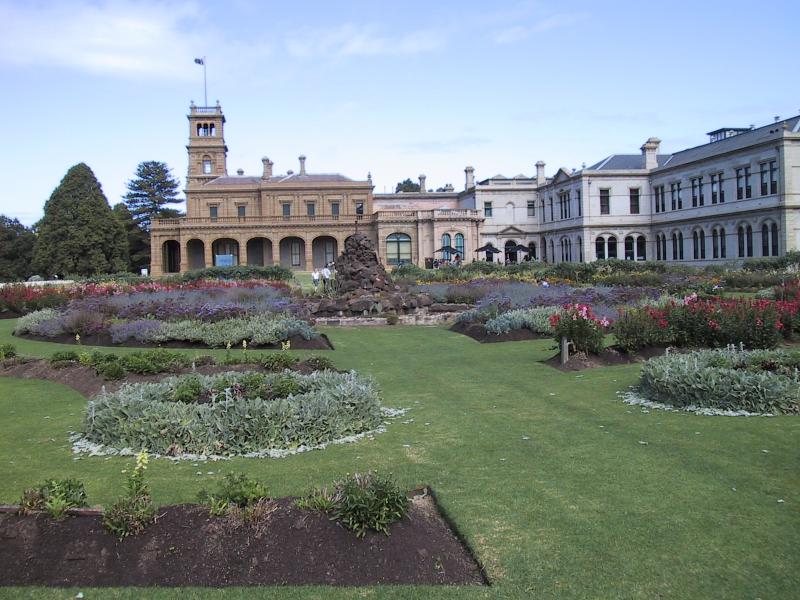
The suburb is best known for its major tourist attractions, which include the former estate of wealthy pastoralist Thomas Chirnside, known as Werribee Park, the Victoria State Rose Garden, the Werribee Park National Equestrian Centre, and the Werribee Open Range Zoo.
The name "Werribee" originated from the Victorian Aboriginal name for the Werribee River, Wirribi-yaluk in Wathawurrung and Boonwurrung, wirribi meaning "backbone" or "spine".
Early leasing of pastures was led by members of John Batman's Port Phillip Association. A rural township began in the early 1850s. This village was named Wyndham (the name of the local municipality today). The name derived from a suggestion by the owner of a local village inn, Elliott Armstrong, who sought to honour Scottish soldier Sir Henry Wyndham. The Post Office opened on 12 January 1858 as Wyndham and was renamed Werribee in 1904. However, its adjacent river was called the Werribee River, and the town's name was later changed to Werribee in 1884, and the Shire Council at that time was also renamed Werribee in 1909. The Shire at the time was quite large; extending from the inner Western suburbs of Melbourne to Little River to the northward town of Melton, covering 715 square kilometres.
Werribee at this time was very popular for development. Thomas Chirnside, a person famous in this area even today, was attracted to the open plain's suitability for agricultural uses. By 1863 he controlled more than 280 square kilometres around Werribee. Chirnside bought other smaller holdings of land at this time. The town grew steadily, helped by a railway line from Melbourne to Geelong, with a station at Werribee in 1857.
Thomas Chirnside committed suicide in 1887. He was found dead in the laundry at Werribee Park with a shotgun lying beside him. His brother Andrew died three years later, and the property was now divided between Andrew's two sons. A new mansion was built, called "The Manor" (not in the same place as the current suburb of Manor Lakes).
Werribee
Werribee is a suburb in Melbourne, Victoria, Australia, 32 km (20 mi) south-west of Melbourne's Central Business District, located within the local government area of the City of Wyndham. Werribee recorded a population of 50,027 at the 2021 census.
Werribee was established as an agricultural settlement in the 1850s, originally named Wyndham and later renamed Werribee (derived from the Aboriginal name meaning "backbone" or "spine") in 1904. The suburb is situated on its namesake the Werribee River, approximately halfway between Melbourne and Geelong, on the Princes Highway. It is the administrative centre of the City of Wyndham local government area and is the City's most populous centre. Werribee is part of the Greater Melbourne metropolitan area and is included in the capital's population statistical division.
Since the 1990s, the suburb has experienced rapid suburban growth into surrounding greenfield land, becoming a commuter town in the Melbourne–Geelong growth corridor. Due to this urban sprawl, Wyndham and its suburbs have merged into the Melbourne conurbation. In recent years, Werribee has undergone development which has seen the growth of high-rise buildings within the city centre.
The suburb is best known for its major tourist attractions, which include the former estate of wealthy pastoralist Thomas Chirnside, known as Werribee Park, the Victoria State Rose Garden, the Werribee Park National Equestrian Centre, and the Werribee Open Range Zoo.
The name "Werribee" originated from the Victorian Aboriginal name for the Werribee River, Wirribi-yaluk in Wathawurrung and Boonwurrung, wirribi meaning "backbone" or "spine".
Early leasing of pastures was led by members of John Batman's Port Phillip Association. A rural township began in the early 1850s. This village was named Wyndham (the name of the local municipality today). The name derived from a suggestion by the owner of a local village inn, Elliott Armstrong, who sought to honour Scottish soldier Sir Henry Wyndham. The Post Office opened on 12 January 1858 as Wyndham and was renamed Werribee in 1904. However, its adjacent river was called the Werribee River, and the town's name was later changed to Werribee in 1884, and the Shire Council at that time was also renamed Werribee in 1909. The Shire at the time was quite large; extending from the inner Western suburbs of Melbourne to Little River to the northward town of Melton, covering 715 square kilometres.
Werribee at this time was very popular for development. Thomas Chirnside, a person famous in this area even today, was attracted to the open plain's suitability for agricultural uses. By 1863 he controlled more than 280 square kilometres around Werribee. Chirnside bought other smaller holdings of land at this time. The town grew steadily, helped by a railway line from Melbourne to Geelong, with a station at Werribee in 1857.
Thomas Chirnside committed suicide in 1887. He was found dead in the laundry at Werribee Park with a shotgun lying beside him. His brother Andrew died three years later, and the property was now divided between Andrew's two sons. A new mansion was built, called "The Manor" (not in the same place as the current suburb of Manor Lakes).
Recent media
Recent media