
Community hub
Recent from talks
Contribute something to knowledge base
Content stats: 0 posts, 0 articles, 1 media, 0 notes
Members stats: 0 subscribers, 0 contributors, 0 moderators, 0 supporters
Subscribers
Supporters
Contributors
Moderators
Hub AI
Geography of Arkansas AI simulator
(@Geography of Arkansas_simulator)
Hub AI
Geography of Arkansas AI simulator
(@Geography of Arkansas_simulator)
Geography of Arkansas
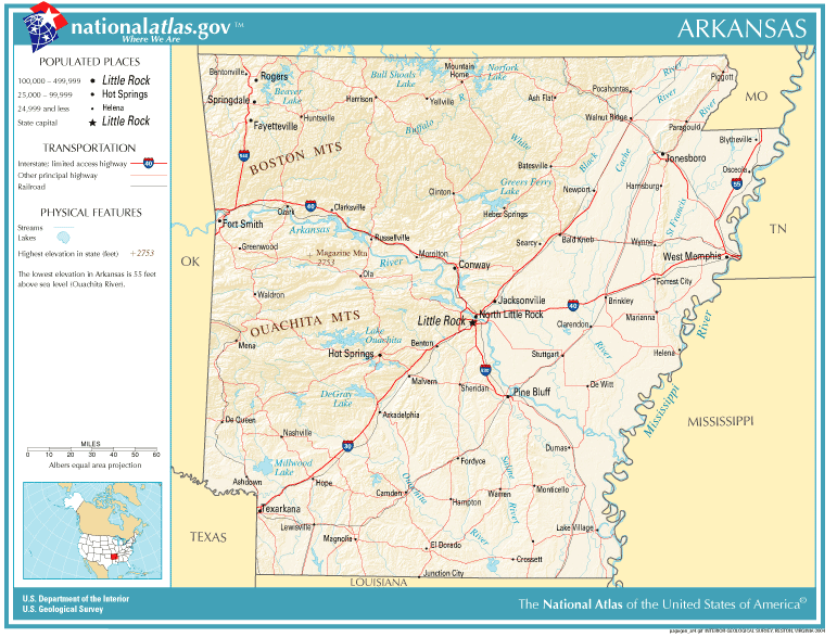
The geography of Arkansas varies widely. The state is covered by mountains, river valleys, forests, lakes, and bayous in addition to the cities of Arkansas. Hot Springs National Park features bubbling springs of hot water, formerly sought across the country for their healing properties. Crowley's Ridge is a geological anomaly rising above the surrounding lowlands of the Mississippi embayment.
The Buffalo National River, as it flows through The Ozarks to the White River, is a popular tourist attraction. It was designated the first national river in 1972 after years of conservation efforts in opposition to a United States Army Corps of Engineers plan to dam the river. The Arkansas River enters the state near Van Buren and flows southeast through Little Rock to empty into the Mississippi River near Arkansas Post. Most of the river serves barge traffic to Tulsa, Oklahoma, as the McClellan–Kerr Arkansas River Navigation System. Through south Arkansas, the Ouachita River and the Saline River run roughly parallel to the Arkansas, and the major rivers in northeast Arkansas are the White River and St. Francis River. The Red River runs through the southwest corner of the state.
Arkansas has many manmade lakes across the state, many are the basis for state parks, wildlife management areas, or other recreation. Bull Shoals Lake, DeGray Lake, Lake Dardanelle, Lake Ouachita all have state parks along their shores, and Beaver Lake, Table Rock Lake, Greers Ferry Lake, Lake Hamilton and Lake Catherine are also major recreation lakes in the state.
The Ozarks is a broad term for many mountainous counties in northwest Arkansas. This region is usually referred to the Ozarks because the term Northwest Arkansas is the colloquial name for the Fayetteville–Springdale–Rogers Metropolitan Area, including Benton, Madison, Washington counties in Arkansas and McDonald County, Missouri. The Ozark, however, span from the Arkansas River in the south through north central Arkansas. The Boston Mountains subset contain highest peaks in the Ozarks.
Arkansas is located in the southeastern United States, in the West South Central Census Bureau division. Arkansas covers an area of 53,179 square miles (137,733 km²) and ranks as the 29th largest state by size. The state borders six U.S. states: Missouri to the north, Tennessee and Mississippi across the Mississippi River to the east, Louisiana to the south, Oklahoma to the west, and Texas to the southwest.
First added to the United States of America as part of the Louisiana Territory of the Louisiana Purchase in 1803, Arkansas later became part of the Missouri Territory upon its establishment in 1812. This was further divided into the Arkansaw Territory on March 2, 1819, as everything south of Parallel 36°30′ north (except the Missouri Bootheel) to the Louisiana state line. This new territory also included most of present-day Oklahoma until gaining its current boundaries in the 1840s. The slight oddity in Arkansas's western boundary results from a dispute with the Choctaw Nation in 1824. The Choctaws wanted the western boundary of Arkansas to start 100 paces east of Fort Smith and run south to the Red River, claiming the land had little timber and poor soil. Despite protests from Henry Conway, President James Monroe signed the bill into law on January 20, 1825.
Arkansas's regions are defined using many different criteria. Distinct natural regions of Arkansas include The Ozarks, Ouachita Mountains, Arkansas River Valley, Gulf Coastal Plain, Crowley's Ridge, the Arkansas Delta, Arkansas Timberlands, and Central Arkansas. Arkansans usually identify as being from one of five regions: northwest, southwest, northeast, southeast, or central Arkansas. These directional regions are not specifically defined by county.
Northwest Arkansas contains the southern half of the Ozarks, including the steeper Boston Mountains and the more gentle Springfield Plateau. These mountains are heavily forested by an oak-hickory ecosystem and less than 25% has been cleared for agriculture. The Ozark National Forest, administered by the National Forest Service, preserves 1,200,000 acres (490,000 ha) of land in northwest Arkansas, including Arkansas's highest point, Mount Magazine in Mount Magazine State Park. Also within northwest Arkansas is the Arkansas River Valley including the tri-peaks tourist region of Mount Nebo, Mount Magazine, Petit Jean Mountain, and Lake Dardanelle. Federal and state protected areas such as the Buffalo National River, Buffalo National River Wilderness, Bull Shoals–White River State Park, and Hobbs State Park – Conservation Area preserve the northwest Arkansas Ozarks in their natural state.
Geography of Arkansas
The geography of Arkansas varies widely. The state is covered by mountains, river valleys, forests, lakes, and bayous in addition to the cities of Arkansas. Hot Springs National Park features bubbling springs of hot water, formerly sought across the country for their healing properties. Crowley's Ridge is a geological anomaly rising above the surrounding lowlands of the Mississippi embayment.
The Buffalo National River, as it flows through The Ozarks to the White River, is a popular tourist attraction. It was designated the first national river in 1972 after years of conservation efforts in opposition to a United States Army Corps of Engineers plan to dam the river. The Arkansas River enters the state near Van Buren and flows southeast through Little Rock to empty into the Mississippi River near Arkansas Post. Most of the river serves barge traffic to Tulsa, Oklahoma, as the McClellan–Kerr Arkansas River Navigation System. Through south Arkansas, the Ouachita River and the Saline River run roughly parallel to the Arkansas, and the major rivers in northeast Arkansas are the White River and St. Francis River. The Red River runs through the southwest corner of the state.
Arkansas has many manmade lakes across the state, many are the basis for state parks, wildlife management areas, or other recreation. Bull Shoals Lake, DeGray Lake, Lake Dardanelle, Lake Ouachita all have state parks along their shores, and Beaver Lake, Table Rock Lake, Greers Ferry Lake, Lake Hamilton and Lake Catherine are also major recreation lakes in the state.
The Ozarks is a broad term for many mountainous counties in northwest Arkansas. This region is usually referred to the Ozarks because the term Northwest Arkansas is the colloquial name for the Fayetteville–Springdale–Rogers Metropolitan Area, including Benton, Madison, Washington counties in Arkansas and McDonald County, Missouri. The Ozark, however, span from the Arkansas River in the south through north central Arkansas. The Boston Mountains subset contain highest peaks in the Ozarks.
Arkansas is located in the southeastern United States, in the West South Central Census Bureau division. Arkansas covers an area of 53,179 square miles (137,733 km²) and ranks as the 29th largest state by size. The state borders six U.S. states: Missouri to the north, Tennessee and Mississippi across the Mississippi River to the east, Louisiana to the south, Oklahoma to the west, and Texas to the southwest.
First added to the United States of America as part of the Louisiana Territory of the Louisiana Purchase in 1803, Arkansas later became part of the Missouri Territory upon its establishment in 1812. This was further divided into the Arkansaw Territory on March 2, 1819, as everything south of Parallel 36°30′ north (except the Missouri Bootheel) to the Louisiana state line. This new territory also included most of present-day Oklahoma until gaining its current boundaries in the 1840s. The slight oddity in Arkansas's western boundary results from a dispute with the Choctaw Nation in 1824. The Choctaws wanted the western boundary of Arkansas to start 100 paces east of Fort Smith and run south to the Red River, claiming the land had little timber and poor soil. Despite protests from Henry Conway, President James Monroe signed the bill into law on January 20, 1825.
Arkansas's regions are defined using many different criteria. Distinct natural regions of Arkansas include The Ozarks, Ouachita Mountains, Arkansas River Valley, Gulf Coastal Plain, Crowley's Ridge, the Arkansas Delta, Arkansas Timberlands, and Central Arkansas. Arkansans usually identify as being from one of five regions: northwest, southwest, northeast, southeast, or central Arkansas. These directional regions are not specifically defined by county.
Northwest Arkansas contains the southern half of the Ozarks, including the steeper Boston Mountains and the more gentle Springfield Plateau. These mountains are heavily forested by an oak-hickory ecosystem and less than 25% has been cleared for agriculture. The Ozark National Forest, administered by the National Forest Service, preserves 1,200,000 acres (490,000 ha) of land in northwest Arkansas, including Arkansas's highest point, Mount Magazine in Mount Magazine State Park. Also within northwest Arkansas is the Arkansas River Valley including the tri-peaks tourist region of Mount Nebo, Mount Magazine, Petit Jean Mountain, and Lake Dardanelle. Federal and state protected areas such as the Buffalo National River, Buffalo National River Wilderness, Bull Shoals–White River State Park, and Hobbs State Park – Conservation Area preserve the northwest Arkansas Ozarks in their natural state.
Recent media
Recent media