Recent from talks
Whitefish, Montana
Knowledge base stats:
Talk channels stats:
Members stats:
Whitefish, Montana
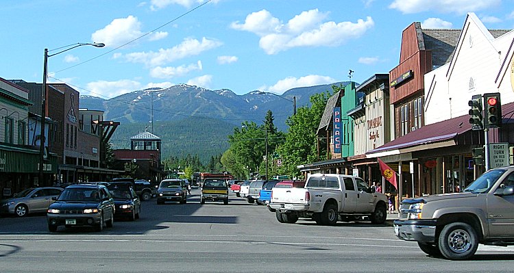
Whitefish (Salish: epɫx̣ʷy̓u, "has whitefish") is a city in Flathead County, Montana, United States. According to the 2020 United States census, there were 7,751 people in the city.
Archaeological records indicate that native American tribes shared hunting grounds in the area, most notably the Kutenai, the Pend d'Oreilles, and the Bitterroot Salish. The Kootenai lived in the area for more than 14,000 years, inhabiting the mountainous terrain west of the Continental Divide, and traveled east of the divide for occasional buffalo hunts. Though trappers, traders, and waves of westward immigrants passed through the area during the second half of the century, it wasn't until 1883 that the first permanent settler, John Morton built a cabin on the shore of Whitefish Lake, just west of the mouth of the Whitefish River. Morton was joined by the local logging industry forefathers—including the Baker and Hutchinson brothers—in the early 1890s. Logging crews "boomed-up" their logs behind a dam built at the river mouth by the Boston & Montana Commercial Company, which, when opened, created a rush of water that helped float the logs down the river to Kalispell.
The Great Northern Railway originally built its line south of Whitefish. When GN rerouted in 1904 to avoid the steep Haskell Pass, preferring a longer but more shallow route via Eureka, the development of what is now Whitefish was sparked. The town incorporated in 1905. The area was originally known as Stumptown due to the abundant amount of timber that had to be cleared to build the town and railroad and because tree stumps were left in the streets throughout downtown. Early residents of the town worked in nearby logging industries and for the railroad. Some of the town's railroad workers were injured and two died in the 1966 Great Northern Buelow collision, an accident that affected many in the area. In 2006, over 68,000 passengers embarked and disembarked through the historic Whitefish Depot, a stop on Amtrak's Empire Builder line, with some percentage of those headed to the ski resort on Big Mountain.
Skiing has been part of the Whitefish area for more than 50 years. In 1937, the Whitefish Lake Ski Club obtained a special permit from the U.S. Forest Service enabling them to build cabins and trails in the Hell Roaring Creek region. Great Falls businessmen Ed Schenck and George Prentice recognized the area's potential and, after World War II, began efforts to develop a full-fledged ski resort on the mountain with local people donating labor, preparing the slopes, even giving up free time to help push through an all-weather mountain road. On December 14, 1947, Schenck, Prentice, and a thousand townsfolk stood on the newly christened ski resort's slopes to watch the brand new T-Bar lift bring their community vision to life. The Whitefish Mountain Resort, built with community effort, attracted visitors.
The town started a curfew siren in 1919 that they called the "ding-dong ordinance". The historic siren was restored to the new city hall.
The town is located on the western side of the continental divide, near Glacier National Park. Whitefish Lake is a 5.2 square miles (13 km2) natural lake with maximum length 5.8 miles (9.3 km) and width 1.4 miles (2.3 km) and is 233 feet (71 m) at its deepest. The Whitefish River bisects the town of Whitefish as it courses south by southeast to briefly join the Stillwater River before its flows enter the Flathead River.
The historic district of Whitefish is a neighborhood called "The Avenues". This neighborhood is bordered by East 2nd Street to the north, Kalispell Avenue to the west, East 7th Street to the south, and Pine Avenue to the east. It is next to downtown, with many of its houses on the historic registry.
According to the Köppen Climate Classification system, Whitefish has a humid continental climate, abbreviated "Dfb" on climate maps. Large seasonal temperature differences typify this climatic region, with warm to hot (and often humid) summers and cold (sometimes severely cold) winters.
Hub AI
Whitefish, Montana AI simulator
(@Whitefish, Montana_simulator)
Whitefish, Montana
Whitefish (Salish: epɫx̣ʷy̓u, "has whitefish") is a city in Flathead County, Montana, United States. According to the 2020 United States census, there were 7,751 people in the city.
Archaeological records indicate that native American tribes shared hunting grounds in the area, most notably the Kutenai, the Pend d'Oreilles, and the Bitterroot Salish. The Kootenai lived in the area for more than 14,000 years, inhabiting the mountainous terrain west of the Continental Divide, and traveled east of the divide for occasional buffalo hunts. Though trappers, traders, and waves of westward immigrants passed through the area during the second half of the century, it wasn't until 1883 that the first permanent settler, John Morton built a cabin on the shore of Whitefish Lake, just west of the mouth of the Whitefish River. Morton was joined by the local logging industry forefathers—including the Baker and Hutchinson brothers—in the early 1890s. Logging crews "boomed-up" their logs behind a dam built at the river mouth by the Boston & Montana Commercial Company, which, when opened, created a rush of water that helped float the logs down the river to Kalispell.
The Great Northern Railway originally built its line south of Whitefish. When GN rerouted in 1904 to avoid the steep Haskell Pass, preferring a longer but more shallow route via Eureka, the development of what is now Whitefish was sparked. The town incorporated in 1905. The area was originally known as Stumptown due to the abundant amount of timber that had to be cleared to build the town and railroad and because tree stumps were left in the streets throughout downtown. Early residents of the town worked in nearby logging industries and for the railroad. Some of the town's railroad workers were injured and two died in the 1966 Great Northern Buelow collision, an accident that affected many in the area. In 2006, over 68,000 passengers embarked and disembarked through the historic Whitefish Depot, a stop on Amtrak's Empire Builder line, with some percentage of those headed to the ski resort on Big Mountain.
Skiing has been part of the Whitefish area for more than 50 years. In 1937, the Whitefish Lake Ski Club obtained a special permit from the U.S. Forest Service enabling them to build cabins and trails in the Hell Roaring Creek region. Great Falls businessmen Ed Schenck and George Prentice recognized the area's potential and, after World War II, began efforts to develop a full-fledged ski resort on the mountain with local people donating labor, preparing the slopes, even giving up free time to help push through an all-weather mountain road. On December 14, 1947, Schenck, Prentice, and a thousand townsfolk stood on the newly christened ski resort's slopes to watch the brand new T-Bar lift bring their community vision to life. The Whitefish Mountain Resort, built with community effort, attracted visitors.
The town started a curfew siren in 1919 that they called the "ding-dong ordinance". The historic siren was restored to the new city hall.
The town is located on the western side of the continental divide, near Glacier National Park. Whitefish Lake is a 5.2 square miles (13 km2) natural lake with maximum length 5.8 miles (9.3 km) and width 1.4 miles (2.3 km) and is 233 feet (71 m) at its deepest. The Whitefish River bisects the town of Whitefish as it courses south by southeast to briefly join the Stillwater River before its flows enter the Flathead River.
The historic district of Whitefish is a neighborhood called "The Avenues". This neighborhood is bordered by East 2nd Street to the north, Kalispell Avenue to the west, East 7th Street to the south, and Pine Avenue to the east. It is next to downtown, with many of its houses on the historic registry.
According to the Köppen Climate Classification system, Whitefish has a humid continental climate, abbreviated "Dfb" on climate maps. Large seasonal temperature differences typify this climatic region, with warm to hot (and often humid) summers and cold (sometimes severely cold) winters.
Recent media