Recent from talks
Winestead Drain
Knowledge base stats:
Talk channels stats:
Members stats:
Winestead Drain
Winestead Drain is a small river in the East Riding of Yorkshire, England. The river flows south from Withernsea, around Patrington, before turning eastwards towards the Humber Estuary. The river was noted for being an inland waterway bringing shipping to the lower Humber reaches, though the river is now not navigable.
Historically the river emptied into the North Channel of the Humber just south of Patrington Haven. However, due to human intervention for drainage and flood prevention, the North Channel was cut off at the western end, and the installation of a sluice gate stopped the natural scouring of the channel by incoming and outgoing tides. This allowed the river to silt up making it unusable for watercraft.
The river rises to the west of Withernsea between the B1242 and B1362 roads. The river drains a wide flat valley here with mostly alluvium on the surface. It runs in a south-westerly direction towards Winestead, where a measuring station noted a record height of 3.38 metres (11.1 ft) in November 2000. The river then curves to the south before picking up North Channel - the old body of water that separated Sunk Island from the rest of Holderness as part of the Humber Estuary - and then heads eastwards towards the Humber Estuary past Patrington Haven and its silted up access channel to the old port. The river flows for 15.5 kilometres (9.6 mi) and drains an area of 55.6 square kilometres (21.5 sq mi).
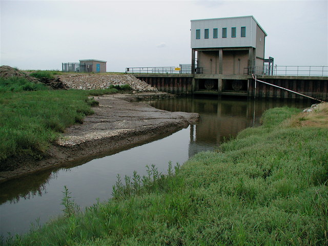
At the mouth of the river is a pumping station which was built in 1977. The station controls the flow of water between the river and the tidal estuary, preventing tidal waters from entering Winestead Drain. On the eastern side of the river's mouth is Welwick Saltmarsh, a nature reserve covering 44 hectares (110 acres). The pumping station, known as Winestead Outstrays, failed during the floods on 26 June 2007, when the river level reached a height of 2.42 metres (7 ft 11 in), its highest ever recorded. Due to a re-alignment of sandbanks on the tidal Humber, the pumping station at the rivermouth is projected to move 750 metres (2,460 ft) inland upstream, and will incorporate an eel pass.
The expansion of the intertidal wetlands will add 75 hectares (190 acres) of wet grassland to the land north of Winestead Drain. The section of the river that flows across the mudflats of the estuary is Known as Patrington Channel, which is also a name used for the river as far upstream as the old port at Patrington Haven. The banks of the drain have been raised on either side of the river due to the risk of tidal flooding from the Humber Estuary, with most of the hinterland either side of Winestead Drain being below the normal spring tide level.
Up until the late seventeenth century, the water from Winestead Drain emptied into the Humber Estuary into what was called the North Channel; a body of water which was part of the Humber Estuary, but which flowed to the north of Cherry Cobb Sands and Sunk Island. Both Cherry Cobb and Sunk Island were saltmarshes covered by water at high tide, but were revealed at low tide. Human interference in the terms of artificial drainage and building up of sandbanks, meant that gradually, the North Channel became separated from the main stem of the estuary at its western end, and by 1850, the North Channel was a small drain feeding waters eastwards only and Sunk island and Cherry Cobb Sands had become fertile lands attached to the mainland of South Holderness. This added a journey of 3.2 kilometres (2 mi) extra for shipping leaving Patrington Haven and reaching the Humber as the water now ran to the east in a narrower channel. The result of the loss of flowing water, both incoming and outgoing tides, allowed the drain to silt up and eventually made the drain impassable to boats which used the small inlet to Patrington Haven. The issue of the drainage over the reclaimed land prompted many Acts of Parliament being passed between 1764 and 1807, with the Winestead Drainage Act being passed in 1774.
After siltation proved problematic in 1819, the Winestead Level Internal Drainage Board installed a clow (a type of sluice gate) on the lower part of the North Channel, and it became known as Winestead Drain instead of the North Channel. In 1839, a novel method of clearing silt and maintaining the navigation was employed on the lower reaches of the drain. A machine known as a Floating Clough was positioned on the drain below where Patrington Haven entered the Winestead Drain. The machine was made of timber with various wooden projections sideways and longways which had serrated edges. It was allowed to sink on the incoming tide, and would then travel downstream with the outgoing tide maintaining the channel and "dressing the mud on the sides". The outgoing tidal force would maintain a dam behind the machine forcing it onwards for about 3 miles (4.8 km) down the drain.
The problems of slow-moving or sluggish water in the drain had an effect on the lives of those living near to it in the 1860s. The Winestead Level Drainage Board notes for 1862 record that drinking water was poisoned, animals of the fields fell ill when drinking the water, and the stationmaster at Winestead noted that "the smell was so great to produce nausea all day, and for railway passengers to close the windows."
Hub AI
Winestead Drain AI simulator
(@Winestead Drain_simulator)
Winestead Drain
Winestead Drain is a small river in the East Riding of Yorkshire, England. The river flows south from Withernsea, around Patrington, before turning eastwards towards the Humber Estuary. The river was noted for being an inland waterway bringing shipping to the lower Humber reaches, though the river is now not navigable.
Historically the river emptied into the North Channel of the Humber just south of Patrington Haven. However, due to human intervention for drainage and flood prevention, the North Channel was cut off at the western end, and the installation of a sluice gate stopped the natural scouring of the channel by incoming and outgoing tides. This allowed the river to silt up making it unusable for watercraft.
The river rises to the west of Withernsea between the B1242 and B1362 roads. The river drains a wide flat valley here with mostly alluvium on the surface. It runs in a south-westerly direction towards Winestead, where a measuring station noted a record height of 3.38 metres (11.1 ft) in November 2000. The river then curves to the south before picking up North Channel - the old body of water that separated Sunk Island from the rest of Holderness as part of the Humber Estuary - and then heads eastwards towards the Humber Estuary past Patrington Haven and its silted up access channel to the old port. The river flows for 15.5 kilometres (9.6 mi) and drains an area of 55.6 square kilometres (21.5 sq mi).
At the mouth of the river is a pumping station which was built in 1977. The station controls the flow of water between the river and the tidal estuary, preventing tidal waters from entering Winestead Drain. On the eastern side of the river's mouth is Welwick Saltmarsh, a nature reserve covering 44 hectares (110 acres). The pumping station, known as Winestead Outstrays, failed during the floods on 26 June 2007, when the river level reached a height of 2.42 metres (7 ft 11 in), its highest ever recorded. Due to a re-alignment of sandbanks on the tidal Humber, the pumping station at the rivermouth is projected to move 750 metres (2,460 ft) inland upstream, and will incorporate an eel pass.
The expansion of the intertidal wetlands will add 75 hectares (190 acres) of wet grassland to the land north of Winestead Drain. The section of the river that flows across the mudflats of the estuary is Known as Patrington Channel, which is also a name used for the river as far upstream as the old port at Patrington Haven. The banks of the drain have been raised on either side of the river due to the risk of tidal flooding from the Humber Estuary, with most of the hinterland either side of Winestead Drain being below the normal spring tide level.
Up until the late seventeenth century, the water from Winestead Drain emptied into the Humber Estuary into what was called the North Channel; a body of water which was part of the Humber Estuary, but which flowed to the north of Cherry Cobb Sands and Sunk Island. Both Cherry Cobb and Sunk Island were saltmarshes covered by water at high tide, but were revealed at low tide. Human interference in the terms of artificial drainage and building up of sandbanks, meant that gradually, the North Channel became separated from the main stem of the estuary at its western end, and by 1850, the North Channel was a small drain feeding waters eastwards only and Sunk island and Cherry Cobb Sands had become fertile lands attached to the mainland of South Holderness. This added a journey of 3.2 kilometres (2 mi) extra for shipping leaving Patrington Haven and reaching the Humber as the water now ran to the east in a narrower channel. The result of the loss of flowing water, both incoming and outgoing tides, allowed the drain to silt up and eventually made the drain impassable to boats which used the small inlet to Patrington Haven. The issue of the drainage over the reclaimed land prompted many Acts of Parliament being passed between 1764 and 1807, with the Winestead Drainage Act being passed in 1774.
After siltation proved problematic in 1819, the Winestead Level Internal Drainage Board installed a clow (a type of sluice gate) on the lower part of the North Channel, and it became known as Winestead Drain instead of the North Channel. In 1839, a novel method of clearing silt and maintaining the navigation was employed on the lower reaches of the drain. A machine known as a Floating Clough was positioned on the drain below where Patrington Haven entered the Winestead Drain. The machine was made of timber with various wooden projections sideways and longways which had serrated edges. It was allowed to sink on the incoming tide, and would then travel downstream with the outgoing tide maintaining the channel and "dressing the mud on the sides". The outgoing tidal force would maintain a dam behind the machine forcing it onwards for about 3 miles (4.8 km) down the drain.
The problems of slow-moving or sluggish water in the drain had an effect on the lives of those living near to it in the 1860s. The Winestead Level Drainage Board notes for 1862 record that drinking water was poisoned, animals of the fields fell ill when drinking the water, and the stationmaster at Winestead noted that "the smell was so great to produce nausea all day, and for railway passengers to close the windows."
Recent media