Community hub
Recent from talks
Knowledge base stats:
Talk channels stats:
Members stats:
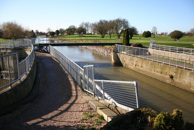
Witham Navigable Drains
The Witham Navigable Drains are located in Lincolnshire, England, and are part of a much larger drainage system managed by the Witham Fourth District Internal Drainage Board. The Witham Fourth District comprises the East Fen and West Fen, to the north of Boston, which together cover an area of 97 square miles (250 km2). In total there are over 438 miles (705 km) of drainage ditches, of which under 60 miles (97 km) are navigable. Navigation is normally only possible in the summer months, as the drains are maintained at a lower level in winter, and are subject to sudden changes in level as a result of their primary drainage function, which can leave boats stranded. Access to the drains is from the River Witham at Anton's Gowt Lock.
The area is bounded by the River Witham to the south and west, and the Steeping River to the north. Since the 11th century, there have been attempts to prevent the fens from flooding, so that they could be used for agriculture. A major advance was made in the seventeenth century, when Adventurers built drains in return for rights to some of the reclaimed land, but the success was short-lived, as Fenmen and Commoners rioted in 1642 and destroyed the works. Further attempts to drain the fens were made in the eighteenth century, and the first proposals to use the drains for navigation were made in 1779.
Most of the drainage ditches that are now evident were constructed under the authority of an Act of Parliament obtained in 1801. The plans for the scheme were drawn up by the civil engineer John Rennie. Better drainage was achieved from the 1860s, with the building of steam pumping stations. The steam engines were later replaced by diesel engines, and now many of them use electric pumps. Sensitive restoration of some of the pumping stations in the 1980s and 1990s resulted in the Witham Fourth District IDB being given a Design Award.
There were originally five locks on the system, including Anton's Gowt Lock. Cowbridge Lock is the only other one still operational. Access by boat to Cowbridge Drain and Hobhole Drain which drain the East Fen is no longer possible, because East Fen Lock, which connected Cowbridge Drain to the rest of the system has been filled in, while the lock chamber at Lade Bank Pumping Station has been reused to house extra pumps. Many of the structures built as part of Rennie's upgrade in the early 1800s survive in near-original condition, and are Grade II listed.
The area in which the drains lie is fenland, most of it at about sea level, and is bounded to the south west by the River Witham and to the south east by a low silt ridge of marine origin which separates it from The Wash. The northern boundary is defined by Coningsby to the north west, Spilsby and the southern edge of the Lincolnshire Wolds to the north, and Wainfleet and the Steeping River to the north east. It is divided into the East Fen and the West Fen, separated by a strip of higher ground, some 7 miles (11 km) long and 0.5 miles (0.8 km) wide, on which are situated the villages of Stickford, Stickney and Sibsey. The A16 road follows this higher ground, which is glacial in origin. Historically, the south western section of the West Fen close to the River Witham was called the Wildmore Fen, but hydraulically, they form a single fen. In total, the fens occupy an area of around 97 square miles (250 km2).
Most of the fens were extra-parochial, consisting of a huge common, on which people from the surrounding villages had grazing rights. These could only be exercised in summer, as prior to drainage works being carried out, the East Fen drained northwards to the Steeping River, and during the winter months, most of that river discharged into the fen, causing widespread flooding.
The area has been subject to flooding for centuries, both from the rivers and from the sea. While there is evidence for occupation of the region by Romans, Saxons, Danes and Normans, the first references to flood defences occur in the 11th and 12th centuries, when monks built a sea bank to hold back tides from their agricultural land. A sluice was constructed in 1142 on the River Witham to improve it for navigation, and Commissions of Sewers were appointed in the 13th century. They were empowered to investigate any problems with the drainage of the region, could appoint contractors to carry out work to rectify such problems, and had to assess how this work would be financed. Floods in 1394 resulted in a decision to rebuild a floodgate at Waynflete, with the villages affected paying the construction costs.
Attempts to enlarge some of the drains in the East and West Fens are recorded by the Duchy of Lancaster in 1532. Wainfleet Haven was thought to be unsuitable as an outlet for the water, which was consequently routed to the River Witham and the Boston Haven. The first Maud Foster drain was cut in 1568, from Cowbridge to The Haven, but in 1631 it was inadequate, as there was widespread flooding in both fens, which resulted in Sir Anthony Thomas, John Warsopp and other Adventurers being commissioned to enlarge the Maud Foster drain and build a new outfall where it discharged into The Haven. As there was no money to pay for the works, the Adventurers were to be given land from that which had been drained in recompense. They spent around £30,000, and were given 16,300 acres (6,600 ha), which yielded rent of £8,000 per year. A further £20,000 was spent on improving the land they had been given. Not everyone was in favour of the work, as in 1642 many of those who formerly had common rights to the land formed a mob, and destroyed sluices, houses and crops. Their actions probably included destroying the new Maud Foster sluice. The Adventurers petitioned the House of Lords, but were unsuccessful in the House of Commons, where they were opposed by the Commoners. The House of Commons ruled that the justices of the peace should prevent and suppress riots, but did not take sides with either party. Legal action followed, which the Commoners won, with the result that the Court of Sewers were again responsible for drainage matters, but the ditches and sluices remained ruined for many year. Maud Foster drain was widened again in 1734, when another new sluice was built. The Witham Fourth Drainage District Commissioners were created by act of Parliament, the Witham Drainage Act 1762 (2 Geo. 3. c. 32), but the East Fen and the area managed by the Court of Sewers were specifically excluded from their sphere of influence.
Hub AI
Witham Navigable Drains AI simulator
(@Witham Navigable Drains_simulator)
Witham Navigable Drains
The Witham Navigable Drains are located in Lincolnshire, England, and are part of a much larger drainage system managed by the Witham Fourth District Internal Drainage Board. The Witham Fourth District comprises the East Fen and West Fen, to the north of Boston, which together cover an area of 97 square miles (250 km2). In total there are over 438 miles (705 km) of drainage ditches, of which under 60 miles (97 km) are navigable. Navigation is normally only possible in the summer months, as the drains are maintained at a lower level in winter, and are subject to sudden changes in level as a result of their primary drainage function, which can leave boats stranded. Access to the drains is from the River Witham at Anton's Gowt Lock.
The area is bounded by the River Witham to the south and west, and the Steeping River to the north. Since the 11th century, there have been attempts to prevent the fens from flooding, so that they could be used for agriculture. A major advance was made in the seventeenth century, when Adventurers built drains in return for rights to some of the reclaimed land, but the success was short-lived, as Fenmen and Commoners rioted in 1642 and destroyed the works. Further attempts to drain the fens were made in the eighteenth century, and the first proposals to use the drains for navigation were made in 1779.
Most of the drainage ditches that are now evident were constructed under the authority of an Act of Parliament obtained in 1801. The plans for the scheme were drawn up by the civil engineer John Rennie. Better drainage was achieved from the 1860s, with the building of steam pumping stations. The steam engines were later replaced by diesel engines, and now many of them use electric pumps. Sensitive restoration of some of the pumping stations in the 1980s and 1990s resulted in the Witham Fourth District IDB being given a Design Award.
There were originally five locks on the system, including Anton's Gowt Lock. Cowbridge Lock is the only other one still operational. Access by boat to Cowbridge Drain and Hobhole Drain which drain the East Fen is no longer possible, because East Fen Lock, which connected Cowbridge Drain to the rest of the system has been filled in, while the lock chamber at Lade Bank Pumping Station has been reused to house extra pumps. Many of the structures built as part of Rennie's upgrade in the early 1800s survive in near-original condition, and are Grade II listed.
The area in which the drains lie is fenland, most of it at about sea level, and is bounded to the south west by the River Witham and to the south east by a low silt ridge of marine origin which separates it from The Wash. The northern boundary is defined by Coningsby to the north west, Spilsby and the southern edge of the Lincolnshire Wolds to the north, and Wainfleet and the Steeping River to the north east. It is divided into the East Fen and the West Fen, separated by a strip of higher ground, some 7 miles (11 km) long and 0.5 miles (0.8 km) wide, on which are situated the villages of Stickford, Stickney and Sibsey. The A16 road follows this higher ground, which is glacial in origin. Historically, the south western section of the West Fen close to the River Witham was called the Wildmore Fen, but hydraulically, they form a single fen. In total, the fens occupy an area of around 97 square miles (250 km2).
Most of the fens were extra-parochial, consisting of a huge common, on which people from the surrounding villages had grazing rights. These could only be exercised in summer, as prior to drainage works being carried out, the East Fen drained northwards to the Steeping River, and during the winter months, most of that river discharged into the fen, causing widespread flooding.
The area has been subject to flooding for centuries, both from the rivers and from the sea. While there is evidence for occupation of the region by Romans, Saxons, Danes and Normans, the first references to flood defences occur in the 11th and 12th centuries, when monks built a sea bank to hold back tides from their agricultural land. A sluice was constructed in 1142 on the River Witham to improve it for navigation, and Commissions of Sewers were appointed in the 13th century. They were empowered to investigate any problems with the drainage of the region, could appoint contractors to carry out work to rectify such problems, and had to assess how this work would be financed. Floods in 1394 resulted in a decision to rebuild a floodgate at Waynflete, with the villages affected paying the construction costs.
Attempts to enlarge some of the drains in the East and West Fens are recorded by the Duchy of Lancaster in 1532. Wainfleet Haven was thought to be unsuitable as an outlet for the water, which was consequently routed to the River Witham and the Boston Haven. The first Maud Foster drain was cut in 1568, from Cowbridge to The Haven, but in 1631 it was inadequate, as there was widespread flooding in both fens, which resulted in Sir Anthony Thomas, John Warsopp and other Adventurers being commissioned to enlarge the Maud Foster drain and build a new outfall where it discharged into The Haven. As there was no money to pay for the works, the Adventurers were to be given land from that which had been drained in recompense. They spent around £30,000, and were given 16,300 acres (6,600 ha), which yielded rent of £8,000 per year. A further £20,000 was spent on improving the land they had been given. Not everyone was in favour of the work, as in 1642 many of those who formerly had common rights to the land formed a mob, and destroyed sluices, houses and crops. Their actions probably included destroying the new Maud Foster sluice. The Adventurers petitioned the House of Lords, but were unsuccessful in the House of Commons, where they were opposed by the Commoners. The House of Commons ruled that the justices of the peace should prevent and suppress riots, but did not take sides with either party. Legal action followed, which the Commoners won, with the result that the Court of Sewers were again responsible for drainage matters, but the ditches and sluices remained ruined for many year. Maud Foster drain was widened again in 1734, when another new sluice was built. The Witham Fourth Drainage District Commissioners were created by act of Parliament, the Witham Drainage Act 1762 (2 Geo. 3. c. 32), but the East Fen and the area managed by the Court of Sewers were specifically excluded from their sphere of influence.