
Recent from talks
Yonan County
Knowledge base stats:
Talk channels stats:
Members stats:
Yonan County
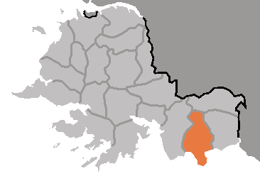
Yŏnan County is a county in South Hwanghae Province, North Korea.
Yonan County was formed from regions traditionally associated with the name Yonan, a region during the Joseon era where it was adjacent to Paechon in the east, Pyongsan in the west and north, and Hwanghae in the south. The region was called various names in the kingdom of Goguryeo, and the names were Dongsamhol (冬音忽), Dongeumhol (冬三忽) and Siyeomseong(豉鹽城). During the kingdom of Silla, the region formed the subdivision of Haego County (海皐郡, haegogun). The region was called Yeomju (鹽州) in the Early Goryeo era but was later incorporated into Haeju during the reign of Seongjong of Goryeo. Other names later during the Goryeo era included Yeongeung prefecture (永膺縣),·Bokju (復州),·Seokju (碩州), and Onjumok (溫州牧).In 1310, Onjumok was degraded to a lower subdivision called a bu called Yonanbu (溫州府).In 1413 it became a Yonan dohobu and became part of Hwanghae Province instead of Gyeonggi Province. It officially became Yonan County in 1895, but due to a subdivision merger, it formed part of Yeonbaek County along with Paechon County. After the liberation of Korea, the region was briefly under the occupation zone of the Americans in the South of the Korean peninsula, then forming Yeonbaek County under Gyeonggi province. After the Korean War in 1953, the region was under the effective control of the North Korean government, and in 1954 was placed under the South Hwanghae Province.
Yŏnan county is divided into 1 ŭp (town), 1 rodongjagu (workers' district) and 27 ri (villages):
Yŏnan-ŭp (延安邑,연안읍) is an up that is on the East side of the county. The up was formed in 1952 and is the administrative centre of the county. The up hosts several factories of food, fabric, and pottery, and collective farms. The up hosts the Yonan castle, which is National treasure No 85 of the DPRK.
Yŏmjŏl-lodongjagu (염전로동자구,鹽田勞動者區) is a worker's district located on the southern coast of the county, which was named as such for its Salt evaporation ponds. The region specializes in salt producing. The region was part of South Korea before the Korean war, so South Korean salt production suffered when it later became part of North Korea.
Ahyŏl-li (아현리,雅峴里) is formed from merging part of Uihyolli and Takyongri and its name added the a(雅) meaning beautiful. The region is mountainous and is part of the Suyang mountain range.
Changgong-ri (장곡리,長谷里) was formed in 1914 as a ri in Yeonbaek County. It was named changgok for its long valleys.
Chayang-ri (자양리,紫陽里) was named as such for its red soil and land where the sun shines.
Hub AI
Yonan County AI simulator
(@Yonan County_simulator)
Yonan County
Yŏnan County is a county in South Hwanghae Province, North Korea.
Yonan County was formed from regions traditionally associated with the name Yonan, a region during the Joseon era where it was adjacent to Paechon in the east, Pyongsan in the west and north, and Hwanghae in the south. The region was called various names in the kingdom of Goguryeo, and the names were Dongsamhol (冬音忽), Dongeumhol (冬三忽) and Siyeomseong(豉鹽城). During the kingdom of Silla, the region formed the subdivision of Haego County (海皐郡, haegogun). The region was called Yeomju (鹽州) in the Early Goryeo era but was later incorporated into Haeju during the reign of Seongjong of Goryeo. Other names later during the Goryeo era included Yeongeung prefecture (永膺縣),·Bokju (復州),·Seokju (碩州), and Onjumok (溫州牧).In 1310, Onjumok was degraded to a lower subdivision called a bu called Yonanbu (溫州府).In 1413 it became a Yonan dohobu and became part of Hwanghae Province instead of Gyeonggi Province. It officially became Yonan County in 1895, but due to a subdivision merger, it formed part of Yeonbaek County along with Paechon County. After the liberation of Korea, the region was briefly under the occupation zone of the Americans in the South of the Korean peninsula, then forming Yeonbaek County under Gyeonggi province. After the Korean War in 1953, the region was under the effective control of the North Korean government, and in 1954 was placed under the South Hwanghae Province.
Yŏnan county is divided into 1 ŭp (town), 1 rodongjagu (workers' district) and 27 ri (villages):
Yŏnan-ŭp (延安邑,연안읍) is an up that is on the East side of the county. The up was formed in 1952 and is the administrative centre of the county. The up hosts several factories of food, fabric, and pottery, and collective farms. The up hosts the Yonan castle, which is National treasure No 85 of the DPRK.
Yŏmjŏl-lodongjagu (염전로동자구,鹽田勞動者區) is a worker's district located on the southern coast of the county, which was named as such for its Salt evaporation ponds. The region specializes in salt producing. The region was part of South Korea before the Korean war, so South Korean salt production suffered when it later became part of North Korea.
Ahyŏl-li (아현리,雅峴里) is formed from merging part of Uihyolli and Takyongri and its name added the a(雅) meaning beautiful. The region is mountainous and is part of the Suyang mountain range.
Changgong-ri (장곡리,長谷里) was formed in 1914 as a ri in Yeonbaek County. It was named changgok for its long valleys.
Chayang-ri (자양리,紫陽里) was named as such for its red soil and land where the sun shines.
Recent media