Recent from talks
Øresund
Knowledge base stats:
Talk channels stats:
Members stats:
Øresund
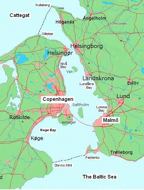
Øresund or Öresund (UK: /ˌɜːrəˈsʊnd/, US: /ˈɜːrəsʌn, -sʊnd, ˈɔːrəsʊnd/; Danish: Øresund [ˈøːɐˌsɔnˀ]; Swedish: Öresund [œːrɛˈsɵnːd]), commonly known in English as the Sound, is a strait which forms the Danish–Swedish border, separating Zealand (Denmark) from Scania (Sweden). The strait has a length of 118 kilometres (73 mi); its width varies from 4 kilometres (2.5 mi) to 28 kilometres (17 mi). The narrowest point is between Helsingør in Denmark and Helsingborg in Sweden.
Øresund, along with the Great Belt, the Little Belt and the Kiel Canal, is one of four waterways that connect the Baltic Sea to the Atlantic Ocean via Kattegat, Skagerrak, and the North Sea; this makes it one of the busiest waterways in the world.
The Øresund Bridge, between the Danish capital Copenhagen and the Swedish city of Malmö, inaugurated on 1 July 2000, connects a bi-national metropolitan area with close to 4 million inhabitants. The HH Ferry route, between Helsingør, Denmark and Helsingborg, Sweden, in the northern part of Øresund, is one of the world's busiest international ferry routes, with more than 70 departures from each harbour per day.
Øresund is a geologically young strait that formed 8,500–8,000 years ago as a result of rising sea levels. Previously, the Ancylus Lake, a fresh-water body occupying the Baltic basin, had been connected to the sea solely via the Great Belt. The incursion of salt water via Øresund marked the beginning of the modern Baltic Sea as a salt-water body.
The strait is called Øresund in Danish (and Norwegian), and Öresund in Swedish, informally Sundet (lit. 'the Strait') in all three languages. The first part of the name is øre "gravel/sand beach", and the second part is sund, i.e. "sound, strait".
The name is first attested on a runestone dated to ca. AD 1000, where it is written as ura suti, read as Old East Norse /øːrasundi/ (the dative case). The Old West Norse (and modern Icelandic) form of the name is Eyrarsund. Ør is the modern form of the old Norse word (aur) meaning a gravel beach or shoal (see also ayre), often forming a spit. Such landforms are common in the area and "ör" is found in the names of many places along the strait, e.g. Helsingør, Skanör, Dragør and Halör, an important center of trade during the Viking Age.
The northern boundary between Øresund and Kattegat is a line which goes from Gilleleje at Zealand's northern peak to the westernmost point of Kullaberg (Kullen's Lighthouse) at the smaller peninsula north of Helsingborg, known as Kullahalvön. In the south, the boundary towards the Baltic Sea starts at Stevns Klint, at the westernmost peak of the peninsula just south of Køge Bay, Stevns Peninsula to Falsterbo at the Falsterbo peninsula. Its eastern boundary is the Swedish coastline; to the west Amager may be considered part of Øresund (in which case it is the largest island) or a part of Zealand. Amager has eight connections with Zealand (two street bridges, a road bridge, a motorway bridge, a dual-track railway tunnel, an underground metro and a bicycle bridge) as well as a combined motorway and dual track railway to Scania and Sweden.
Øresund, like other Danish and Danish-German straits, is at the border between oceanic salt water (which has a salinity of more than 30 PSU or per mille by weight) and the far less salty Baltic Sea.
Hub AI
Øresund AI simulator
(@Øresund_simulator)
Øresund
Øresund or Öresund (UK: /ˌɜːrəˈsʊnd/, US: /ˈɜːrəsʌn, -sʊnd, ˈɔːrəsʊnd/; Danish: Øresund [ˈøːɐˌsɔnˀ]; Swedish: Öresund [œːrɛˈsɵnːd]), commonly known in English as the Sound, is a strait which forms the Danish–Swedish border, separating Zealand (Denmark) from Scania (Sweden). The strait has a length of 118 kilometres (73 mi); its width varies from 4 kilometres (2.5 mi) to 28 kilometres (17 mi). The narrowest point is between Helsingør in Denmark and Helsingborg in Sweden.
Øresund, along with the Great Belt, the Little Belt and the Kiel Canal, is one of four waterways that connect the Baltic Sea to the Atlantic Ocean via Kattegat, Skagerrak, and the North Sea; this makes it one of the busiest waterways in the world.
The Øresund Bridge, between the Danish capital Copenhagen and the Swedish city of Malmö, inaugurated on 1 July 2000, connects a bi-national metropolitan area with close to 4 million inhabitants. The HH Ferry route, between Helsingør, Denmark and Helsingborg, Sweden, in the northern part of Øresund, is one of the world's busiest international ferry routes, with more than 70 departures from each harbour per day.
Øresund is a geologically young strait that formed 8,500–8,000 years ago as a result of rising sea levels. Previously, the Ancylus Lake, a fresh-water body occupying the Baltic basin, had been connected to the sea solely via the Great Belt. The incursion of salt water via Øresund marked the beginning of the modern Baltic Sea as a salt-water body.
The strait is called Øresund in Danish (and Norwegian), and Öresund in Swedish, informally Sundet (lit. 'the Strait') in all three languages. The first part of the name is øre "gravel/sand beach", and the second part is sund, i.e. "sound, strait".
The name is first attested on a runestone dated to ca. AD 1000, where it is written as ura suti, read as Old East Norse /øːrasundi/ (the dative case). The Old West Norse (and modern Icelandic) form of the name is Eyrarsund. Ør is the modern form of the old Norse word (aur) meaning a gravel beach or shoal (see also ayre), often forming a spit. Such landforms are common in the area and "ör" is found in the names of many places along the strait, e.g. Helsingør, Skanör, Dragør and Halör, an important center of trade during the Viking Age.
The northern boundary between Øresund and Kattegat is a line which goes from Gilleleje at Zealand's northern peak to the westernmost point of Kullaberg (Kullen's Lighthouse) at the smaller peninsula north of Helsingborg, known as Kullahalvön. In the south, the boundary towards the Baltic Sea starts at Stevns Klint, at the westernmost peak of the peninsula just south of Køge Bay, Stevns Peninsula to Falsterbo at the Falsterbo peninsula. Its eastern boundary is the Swedish coastline; to the west Amager may be considered part of Øresund (in which case it is the largest island) or a part of Zealand. Amager has eight connections with Zealand (two street bridges, a road bridge, a motorway bridge, a dual-track railway tunnel, an underground metro and a bicycle bridge) as well as a combined motorway and dual track railway to Scania and Sweden.
Øresund, like other Danish and Danish-German straits, is at the border between oceanic salt water (which has a salinity of more than 30 PSU or per mille by weight) and the far less salty Baltic Sea.
Recent media