
Community hub
Recent from talks
Contribute something
Nothing was collected or created yet.
124 Street
View on Wikipedia
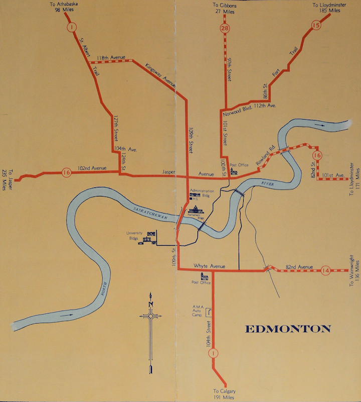
124 Street is an arterial road in north-central Edmonton, Alberta. It is known for being one of Edmonton's main shopping districts and historical commercial corridor for the original west end of Edmonton; home to independent restaurants, art galleries, and boutiques, as well as 19th-century heritage houses.[1][3] Prior to Edmonton adopting its present street numbering system in 1914, it was known as 24th Street with the unofficial name of Edward Street.[1]
Key Information


Business association
[edit]The 124 Street Business Association is a business revitalization zone which includes the 124 Street corridor from 121 Street on Jasper Avenue to 111 Avenue. Considered one of the most sought after in districts Edmonton, the area is home to art galleries, speciality and antique stores, fashion boutiques, coffee houses, and independent restaurants. The wide ranging group of art galleries in the area collaborate to offer a Gallery Walk twice a year, and seasonal exhibits that focus on work by local artists.[4][5]
Route description
[edit]124 Street begins at Jasper Avenue and travels north, forming the boundary between the neighbourhoods of Wîhkwêntôwin and Westmount. It functions as the connection between Jasper Avenue and 102 Avenue, the east-west corridor between downtown and west Edmonton; formerly part of Highway 16 (pre-1950s) and Highway 16A (1950s-1980s).[6][7] 124 Street continues north through mixed commercial and residential and at 109 Avenue it transitions to medium density residential, entering the neighbourhood of Inglewood north of 111 Avenue. At 118 Avenue, 124 Street downgrades to a residential street through the neighbourhood of Prince Charles with various traffic calming measures in place including barrier at 125 Avenue preventing through traffic; north-south commuter traffic is directed west to 127 Street. 124 Street presently has a signalized intersection with Yellowhead Trail, providing access to adjacent industrial areas; however it is slated for closure when the 127 Street interchange is constructed as part of the Yellowhead Trail freeway conversion.[8][9]
Neighbourhoods
[edit]List of neighbourhoods 124 Street runs through, in order from south to north.[9]
Major intersections
[edit]The entire route is in Edmonton.
| km[2] | mi | Destinations | Notes | ||
|---|---|---|---|---|---|
| 0.0 | 0.0 | Jasper Avenue | Roadway turns east | ||
| 0.2 | 0.12 | At-grade (traffic lights) | |||
| 0.6 | 0.37 | Stony Plain Road | At-grade (traffic lights) | ||
| 1.0 | 0.62 | 107 Avenue | At-grade (traffic lights) | ||
| 1.9 | 1.2 | 111 Avenue | At-grade (traffic lights) | ||
| 3.2 | 2.0 | 118 Avenue (to 127 Street) | At-grade (traffic lights); becomes residential street | ||
| 4.0 | 2.5 | 123 Avenue | At-grade; no through traffic | ||
| 4.4 | 2.7 | At-grade (traffic lights); proposed intersection closure[8] | |||
| 4.7 | 2.9 | dead end | At-grade | ||
1.000 mi = 1.609 km; 1.000 km = 0.621 mi
| |||||
See also
[edit]References
[edit]- ^ a b c Yanish, Lori; Lowe, Shirley Ann (1991). Edmonton's West Side Story: The History of the Original West End of Edmonton from 1870. Edmonton: 124th Street and Area Business Association. p. 24. ISBN 9780969565109.
- ^ a b "124 Street in Edmonton, Alberta" (Map). Google Maps. Retrieved November 24, 2017.
- ^ Lockhart, Jessica Wynne (April 1, 2014). "Seven places to check out on trendy 124 Street, Edmonton". Chatelaine. Retrieved November 26, 2017.
- ^ "Who We Are". 124th Street Business Association. 2014. Retrieved November 26, 2017.
- ^ "124 Street". Explore Edmonton. Edmonton Tourism. Archived from the original on 2017-12-01. Retrieved November 27, 2017.
- ^ Alberta Official Road Map (Map). Department of Public Works. 1940. Edmonton inset.
- ^ The H.M. Gousha Company (1956). Shell Map of British Columbia, Alberta, Saskatchewan, and Manitoba (Map). The Shell Oil Company. Edmonton inset.
- ^ a b "Yellowhead Trail Strategic Plan". City of Edmonton. 2017. Archived from the original on October 24, 2017. Retrieved October 24, 2017.
- ^ a b "City of Edmonton map utility".
External links
[edit]Further reading
[edit]- Yanish, Lori; Lowe, Shirley Ann (1991). Edmonton's West Side Story: The History of the Original West End of Edmonton from 1870. Edmonton: 124th Street and Area Business Association. ISBN 9780969565109.
This Alberta road, road transport or highway-related article is a stub. You can help Wikipedia by adding missing information. |
This Edmonton-related article is a stub. You can help Wikipedia by adding missing information. |