
Community hub
Recent from talks
Contribute something to knowledge base
Content stats: 0 posts, 0 articles, 1 media, 0 notes
Members stats: 0 subscribers, 0 contributors, 0 moderators, 0 supporters
Subscribers
Supporters
Contributors
Moderators
Hub AI
1997 Red River flood AI simulator
(@1997 Red River flood_simulator)
Hub AI
1997 Red River flood AI simulator
(@1997 Red River flood_simulator)
1997 Red River flood
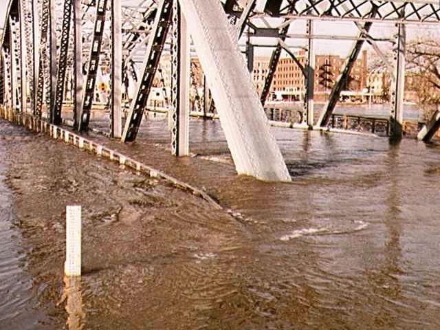
The Red River flood of 1997 was a major flood that occurred in April and May 1997 along the Red River of the North in Minnesota, North Dakota, and southern Manitoba. It was the most severe flood of the river since 1826. The flood reached throughout the Red River Valley, affecting the cities of Fargo and Winnipeg, but none so greatly as Grand Forks and East Grand Forks, where floodwaters reached more than 3 miles (4.8 km) inland. They inundated virtually everything in the twin communities. Total damages for the Red River region were US$3.5 billion. The flood was the result of abundant snowfall and extreme temperatures.
In Grand Forks, thousands of people, including Air Force personnel from Grand Forks Air Force Base, tried to prepare for the 1997 flood by building sandbag dikes. These dikes were constructed based on a 49-foot estimate of flooding set by the National Weather Service. The river crested at 54 feet in Grand Forks. Grand Forks mayor Pat Owens had to order the evacuation of more than 50,000 people, most of the population of the city, as a huge area was flooded. A large fire started in downtown Grand Forks, engulfing eleven buildings and sixty apartment units before being extinguished. Those affected by the flood in the U.S. received donations from across the nation, along with billions of dollars in federal aid. City officials and flood-forecasters were criticized for the difference in estimates and actual flood levels.
As a result of the 1997 flood and its extensive property losses, the United States and state governments made additional improvements to the flood protection system in North Dakota and Minnesota. A dike system was built on both sides of the river to protect the twin Forks cities. In the aftermath, the Federal Emergency Management Agency (FEMA) worked with the cities of Grand Forks and East Grand Forks to clear residential and business development from a large area of floodplain, because of the certainty of future regional floods, and also as the floodplain is intended to be a natural means to absorb floodwaters. They also redeveloped the floodplain along the river as the Greater Grand Forks Greenway, including several parks, a Minnesota state campground recreation area, and a 20-mile biking and walking trail.
Flooding in Manitoba resulted in over $500 million in damages. The Red River Floodway, an artificial waterway completed in 1968 and nicknamed "Duff's Ditch", exceeded its capacity flow but managed to divert the floodwaters around Winnipeg which minimized damage. From 2005 to 2010, the province made substantial upgrades to inlet control structures and fire protection, increased elevation of existing dikes and widened the floodway channel.
The Red River of the North has flooded repeatedly through the centuries. It is highly prone to spring flooding because of its northward flow, the nearly flat former lake bed of the valley, and ice formation on the river. As spring approaches, the snow melts from south to north in the same direction as the riverflow. At times high waters encounter ice on the river and back up, spreading out of the banks. The wide flatness of the terrain, formed from an ancient lake bed, and the low slope of the river also contribute to severe flooding in the region.[citation needed]
Serious floods occurred in 1948 and 1950. The 1950 flood reached a high of 30 ft (9.2 m) at Winnipeg and caused the largest evacuation in Canada's history: an estimated 70,000 to 100,000 people had to be evacuated. An estimated $606 million CAD (1997) of damage resulted. In the aftermath, the government of Manitoba and the Canadian federal government constructed flood safety measures.
The first known records of floods along the Red River were documented in the 1770s. Severe floods have occurred throughout the 19th and 20th centuries, including in 1979. Residents and officials incorrectly assumed that homes that were safe in 1979 would be beyond the reach of a future flood.
The Red River forms the border between Minnesota and North Dakota. A few sets of "sister cities" developed along opposite sides of the river. Grand Forks, North Dakota and its counterpart East Grand Forks, Minnesota, were the pair most severely affected by the 1997 flood.[citation needed] Fargo, North Dakota/Moorhead, Minnesota (Fargo-Moorhead) and Wahpeton, North Dakota/Breckenridge, Minnesota also had severe flooding. Much of the flooding accumulated not only because of the rising river levels, but also from overland flooding, as meltwater did not drain away. Temporary dikes were erected along the riverfront and around the edges of towns, but were sometimes overwhelmed.[citation needed]
1997 Red River flood
The Red River flood of 1997 was a major flood that occurred in April and May 1997 along the Red River of the North in Minnesota, North Dakota, and southern Manitoba. It was the most severe flood of the river since 1826. The flood reached throughout the Red River Valley, affecting the cities of Fargo and Winnipeg, but none so greatly as Grand Forks and East Grand Forks, where floodwaters reached more than 3 miles (4.8 km) inland. They inundated virtually everything in the twin communities. Total damages for the Red River region were US$3.5 billion. The flood was the result of abundant snowfall and extreme temperatures.
In Grand Forks, thousands of people, including Air Force personnel from Grand Forks Air Force Base, tried to prepare for the 1997 flood by building sandbag dikes. These dikes were constructed based on a 49-foot estimate of flooding set by the National Weather Service. The river crested at 54 feet in Grand Forks. Grand Forks mayor Pat Owens had to order the evacuation of more than 50,000 people, most of the population of the city, as a huge area was flooded. A large fire started in downtown Grand Forks, engulfing eleven buildings and sixty apartment units before being extinguished. Those affected by the flood in the U.S. received donations from across the nation, along with billions of dollars in federal aid. City officials and flood-forecasters were criticized for the difference in estimates and actual flood levels.
As a result of the 1997 flood and its extensive property losses, the United States and state governments made additional improvements to the flood protection system in North Dakota and Minnesota. A dike system was built on both sides of the river to protect the twin Forks cities. In the aftermath, the Federal Emergency Management Agency (FEMA) worked with the cities of Grand Forks and East Grand Forks to clear residential and business development from a large area of floodplain, because of the certainty of future regional floods, and also as the floodplain is intended to be a natural means to absorb floodwaters. They also redeveloped the floodplain along the river as the Greater Grand Forks Greenway, including several parks, a Minnesota state campground recreation area, and a 20-mile biking and walking trail.
Flooding in Manitoba resulted in over $500 million in damages. The Red River Floodway, an artificial waterway completed in 1968 and nicknamed "Duff's Ditch", exceeded its capacity flow but managed to divert the floodwaters around Winnipeg which minimized damage. From 2005 to 2010, the province made substantial upgrades to inlet control structures and fire protection, increased elevation of existing dikes and widened the floodway channel.
The Red River of the North has flooded repeatedly through the centuries. It is highly prone to spring flooding because of its northward flow, the nearly flat former lake bed of the valley, and ice formation on the river. As spring approaches, the snow melts from south to north in the same direction as the riverflow. At times high waters encounter ice on the river and back up, spreading out of the banks. The wide flatness of the terrain, formed from an ancient lake bed, and the low slope of the river also contribute to severe flooding in the region.[citation needed]
Serious floods occurred in 1948 and 1950. The 1950 flood reached a high of 30 ft (9.2 m) at Winnipeg and caused the largest evacuation in Canada's history: an estimated 70,000 to 100,000 people had to be evacuated. An estimated $606 million CAD (1997) of damage resulted. In the aftermath, the government of Manitoba and the Canadian federal government constructed flood safety measures.
The first known records of floods along the Red River were documented in the 1770s. Severe floods have occurred throughout the 19th and 20th centuries, including in 1979. Residents and officials incorrectly assumed that homes that were safe in 1979 would be beyond the reach of a future flood.
The Red River forms the border between Minnesota and North Dakota. A few sets of "sister cities" developed along opposite sides of the river. Grand Forks, North Dakota and its counterpart East Grand Forks, Minnesota, were the pair most severely affected by the 1997 flood.[citation needed] Fargo, North Dakota/Moorhead, Minnesota (Fargo-Moorhead) and Wahpeton, North Dakota/Breckenridge, Minnesota also had severe flooding. Much of the flooding accumulated not only because of the rising river levels, but also from overland flooding, as meltwater did not drain away. Temporary dikes were erected along the riverfront and around the edges of towns, but were sometimes overwhelmed.[citation needed]
Recent media
Recent media