
Community hub
Recent from talks
Contribute something to knowledge base
Content stats: 0 posts, 0 articles, 1 media, 0 notes
Members stats: 0 subscribers, 0 contributors, 0 moderators, 0 supporters
Subscribers
Supporters
Contributors
Moderators
Hub AI
Adel, Leeds AI simulator
(@Adel, Leeds_simulator)
Hub AI
Adel, Leeds AI simulator
(@Adel, Leeds_simulator)
Adel, Leeds
Adel (/ˈædl/ ADD-əl) is a suburb of Leeds, West Yorkshire, England. To its immediate south is Weetwood, to the west are Cookridge and Holt Park, to the east are Alwoodley and Moortown, and to the north are Bramhope, Arthington and Eccup.
It forms part of the Leeds City Council ward of Adel & Wharfedale and the parliamentary constituency of Leeds North West.
In common with many areas of Leeds it is not easy to define the boundaries of Adel, but Adel Church and the two schools are well to the east of Otley Road, the A660, although the post office is on that road.
Adel is situated near the site of a Roman fort, the ancient road from Tadcaster to Ilkley passing nearby. (The footpath by the side of Long Causeway was said to be made from the original Roman stones, until they were removed by the council in the 1960s because they were unsafe. Some of the footpath has been replaced, starting at the junction between Long Causeway and Stairfoot Lane, and continuing up to the entrance of Bedquilts playing fields.) Several inscribed stones from the Romano-British period were discovered in Adel, also a number of Anglo-Saxon stones were discovered in the church foundations during restoration work in 1864. Some of these items are on display in the Leeds City Museum, Cookridge Street. Among the foundation stones of Roman buildings found near Eccup Moor in 1702 were two altars, inscribed PIENTISSIMA, and D.M.S. CANDIDINAE, FORTUNA PIA V.A.X. respectively. Several large urns were also found there. On the side of the 'hill of Ada,' an altar dedicated to Brigantia DEAE BRIGANTIAE DONUM CINGE/ TISSA POSUIT, along with some statues and coins were later found. In 1849, a stone coffin was found on Addle Mill Farm.
The Roman name for the area is long thought to have been Burgodunum, but the Yorkshire Archaeological Society argues that this is "dubious". An alternative name is also Burgodurum, meaning the Fort by the Waterway. It has also been suggested that this was shortened to Burden, which is similar in sound to the Celtic Verdun, found in Belgium. It is probable that an Angle village sprang up around the fort and that a church was built in the village. Adel is mentioned in the 1086 Domesday Book as Adele. Another spelling used until 1816 is Addle. Most recent authorities derive the name from the Old English adela ‘dirty, muddy place’, but arguments have also been made for a personal name Ada (or similar Anglo-Saxon names such as Eadda, Eada or Ædda) + Old English lēah 'open ground, lea' (compare the terminus spelling of nearby Headingley DB: Hedingelei & hedingeleia).
The parish of Adel stretched to the River Wharfe in the north and included Adel, Arthington, Breary, Cookridge and Eccup. In 1831 the parish had a population of 1063. In 1866 the parish was abolished.
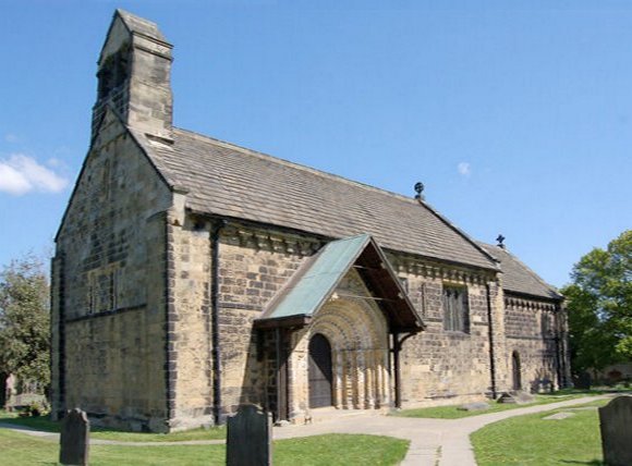
In 1152, the nearby Cistercian abbey at Kirkstall was founded. At the same time, the church of St John the Baptist was built in Adel to replace the older Saxon building. Although the present church is Norman, it looks quite similar to the late 7th century Anglo-Saxon church in Ledsham village, "the oldest church (and the oldest building) standing in West Yorkshire".
The Church of St John the Baptist, Adel parish church, is described as "one of the best and most complete Norman churches in Yorkshire". It is a Grade I listed building; the sundial, mounting block and several memorials are Grade II listed.
Adel, Leeds
Adel (/ˈædl/ ADD-əl) is a suburb of Leeds, West Yorkshire, England. To its immediate south is Weetwood, to the west are Cookridge and Holt Park, to the east are Alwoodley and Moortown, and to the north are Bramhope, Arthington and Eccup.
It forms part of the Leeds City Council ward of Adel & Wharfedale and the parliamentary constituency of Leeds North West.
In common with many areas of Leeds it is not easy to define the boundaries of Adel, but Adel Church and the two schools are well to the east of Otley Road, the A660, although the post office is on that road.
Adel is situated near the site of a Roman fort, the ancient road from Tadcaster to Ilkley passing nearby. (The footpath by the side of Long Causeway was said to be made from the original Roman stones, until they were removed by the council in the 1960s because they were unsafe. Some of the footpath has been replaced, starting at the junction between Long Causeway and Stairfoot Lane, and continuing up to the entrance of Bedquilts playing fields.) Several inscribed stones from the Romano-British period were discovered in Adel, also a number of Anglo-Saxon stones were discovered in the church foundations during restoration work in 1864. Some of these items are on display in the Leeds City Museum, Cookridge Street. Among the foundation stones of Roman buildings found near Eccup Moor in 1702 were two altars, inscribed PIENTISSIMA, and D.M.S. CANDIDINAE, FORTUNA PIA V.A.X. respectively. Several large urns were also found there. On the side of the 'hill of Ada,' an altar dedicated to Brigantia DEAE BRIGANTIAE DONUM CINGE/ TISSA POSUIT, along with some statues and coins were later found. In 1849, a stone coffin was found on Addle Mill Farm.
The Roman name for the area is long thought to have been Burgodunum, but the Yorkshire Archaeological Society argues that this is "dubious". An alternative name is also Burgodurum, meaning the Fort by the Waterway. It has also been suggested that this was shortened to Burden, which is similar in sound to the Celtic Verdun, found in Belgium. It is probable that an Angle village sprang up around the fort and that a church was built in the village. Adel is mentioned in the 1086 Domesday Book as Adele. Another spelling used until 1816 is Addle. Most recent authorities derive the name from the Old English adela ‘dirty, muddy place’, but arguments have also been made for a personal name Ada (or similar Anglo-Saxon names such as Eadda, Eada or Ædda) + Old English lēah 'open ground, lea' (compare the terminus spelling of nearby Headingley DB: Hedingelei & hedingeleia).
The parish of Adel stretched to the River Wharfe in the north and included Adel, Arthington, Breary, Cookridge and Eccup. In 1831 the parish had a population of 1063. In 1866 the parish was abolished.
In 1152, the nearby Cistercian abbey at Kirkstall was founded. At the same time, the church of St John the Baptist was built in Adel to replace the older Saxon building. Although the present church is Norman, it looks quite similar to the late 7th century Anglo-Saxon church in Ledsham village, "the oldest church (and the oldest building) standing in West Yorkshire".
The Church of St John the Baptist, Adel parish church, is described as "one of the best and most complete Norman churches in Yorkshire". It is a Grade I listed building; the sundial, mounting block and several memorials are Grade II listed.
Recent media
Recent media