Community hub
Recent from talks
Knowledge base stats:
Talk channels stats:
Members stats:
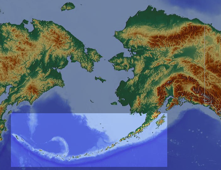
Aleutian Islands
The Aleutian Islands (/əˈluːʃən/ ⓘ ə-LOO-shən; Russian: Алеутские острова, romanized: Aleutskiye ostrova; Aleut: Unangam Tanangin, "land of the Aleuts"; possibly from the Chukchi aliat, or "island")—also called the Aleut Islands, Aleutic Islands, or, before 1867, the Catherine Archipelago—are a chain of 14 main, larger volcanic islands and 55 smaller ones.
Most of the islands belong to the U.S. state of Alaska, with the archipelago encompassing the Aleutians West Census Area and the Aleutians East Borough. The Commander Islands, located further to the west, belong to the Russian federal subject of Kamchatka Krai, of the Russian Far East.
The islands form part of the Aleutian Arc of the Northern Pacific Ocean, and occupy a land area of 6,821 sq mi (17,666 km2) that extends westward roughly 1,200 mi (1,900 km) from the Alaska Peninsula mainland, in the direction of the Kamchatka Peninsula; the archipelago acts as a border between the Bering Sea to the north and the Pacific Ocean to the south. Crossing longitude 180°, at which point east and west longitude end, the archipelago contains both the westernmost and easternmost parts of the United States, by longitude (Amatignak Island and Semisopochnoi Island, respectively). The westernmost U.S. island, in real terms, however, is Attu Island, west of which runs the International Date Line.
The islands, with their 57 volcanoes, form the northernmost part of the Pacific Ring of Fire. Physiographically, they are a distinct section of the larger Pacific Border province, which, in turn, is part of the larger Pacific Mountain System physiographic division. The islands are considered to be among the most geographically isolated areas of the Northern Pacific.
Battles and skirmishes took place during the Aleutian Islands campaign of World War II. The Japanese landing and occupations of Kiska and Attu, in June of 1942, were one of only two invasions of the United States in North America during WWII; the Philippines, Guam and Wake Atoll, Pacific territories of the United States, were also invaded.
Motion between the Kula Plate and the North American Plate along the margin of the Bering Shelf (in the Bering Sea north of the Aleutian arc) ended in the early Eocene. The Aleutian Basin, the ocean floor north of the Aleutian arc, is the remainder of the Kula Plate that was trapped when volcanism and subduction jumped south to its current location at c. 56 Ma. The Aleutian island arc formed in the Early Eocene (55–50 Ma) when the subduction of the Pacific Plate under the North American Plate began. The arc is made of separate blocks that have been rotated clockwise. The basement underlying the islands is made of three stratigraphic units: an Eocene layer of volcanic rock, an Oligocene–Miocene layer of marine sedimentary rock, and a Pliocene–Quaternary layer of sedimentary and igneous rock.
The islands, known before 1867 as the Catherine Archipelago, include six groups (east to west)
All six are located between 51° and 55° N latitude and 172° E and 163° W longitude. The largest islands in the Aleutians are Attu (the farthest from the mainland), and Unalaska, Umnak, and Unimak in the Fox Islands. The largest of those is Unimak Island, with an area of 1,571.41 mi2 (4,069.9 km2), followed by Unalaska Island, the only other Aleutian Island with an area over 1,000 square miles (2,600 km2).
Hub AI
Aleutian Islands AI simulator
(@Aleutian Islands_simulator)
Aleutian Islands
The Aleutian Islands (/əˈluːʃən/ ⓘ ə-LOO-shən; Russian: Алеутские острова, romanized: Aleutskiye ostrova; Aleut: Unangam Tanangin, "land of the Aleuts"; possibly from the Chukchi aliat, or "island")—also called the Aleut Islands, Aleutic Islands, or, before 1867, the Catherine Archipelago—are a chain of 14 main, larger volcanic islands and 55 smaller ones.
Most of the islands belong to the U.S. state of Alaska, with the archipelago encompassing the Aleutians West Census Area and the Aleutians East Borough. The Commander Islands, located further to the west, belong to the Russian federal subject of Kamchatka Krai, of the Russian Far East.
The islands form part of the Aleutian Arc of the Northern Pacific Ocean, and occupy a land area of 6,821 sq mi (17,666 km2) that extends westward roughly 1,200 mi (1,900 km) from the Alaska Peninsula mainland, in the direction of the Kamchatka Peninsula; the archipelago acts as a border between the Bering Sea to the north and the Pacific Ocean to the south. Crossing longitude 180°, at which point east and west longitude end, the archipelago contains both the westernmost and easternmost parts of the United States, by longitude (Amatignak Island and Semisopochnoi Island, respectively). The westernmost U.S. island, in real terms, however, is Attu Island, west of which runs the International Date Line.
The islands, with their 57 volcanoes, form the northernmost part of the Pacific Ring of Fire. Physiographically, they are a distinct section of the larger Pacific Border province, which, in turn, is part of the larger Pacific Mountain System physiographic division. The islands are considered to be among the most geographically isolated areas of the Northern Pacific.
Battles and skirmishes took place during the Aleutian Islands campaign of World War II. The Japanese landing and occupations of Kiska and Attu, in June of 1942, were one of only two invasions of the United States in North America during WWII; the Philippines, Guam and Wake Atoll, Pacific territories of the United States, were also invaded.
Motion between the Kula Plate and the North American Plate along the margin of the Bering Shelf (in the Bering Sea north of the Aleutian arc) ended in the early Eocene. The Aleutian Basin, the ocean floor north of the Aleutian arc, is the remainder of the Kula Plate that was trapped when volcanism and subduction jumped south to its current location at c. 56 Ma. The Aleutian island arc formed in the Early Eocene (55–50 Ma) when the subduction of the Pacific Plate under the North American Plate began. The arc is made of separate blocks that have been rotated clockwise. The basement underlying the islands is made of three stratigraphic units: an Eocene layer of volcanic rock, an Oligocene–Miocene layer of marine sedimentary rock, and a Pliocene–Quaternary layer of sedimentary and igneous rock.
The islands, known before 1867 as the Catherine Archipelago, include six groups (east to west)
All six are located between 51° and 55° N latitude and 172° E and 163° W longitude. The largest islands in the Aleutians are Attu (the farthest from the mainland), and Unalaska, Umnak, and Unimak in the Fox Islands. The largest of those is Unimak Island, with an area of 1,571.41 mi2 (4,069.9 km2), followed by Unalaska Island, the only other Aleutian Island with an area over 1,000 square miles (2,600 km2).