Recent from talks
Aranno
Knowledge base stats:
Talk channels stats:
Members stats:
Aranno
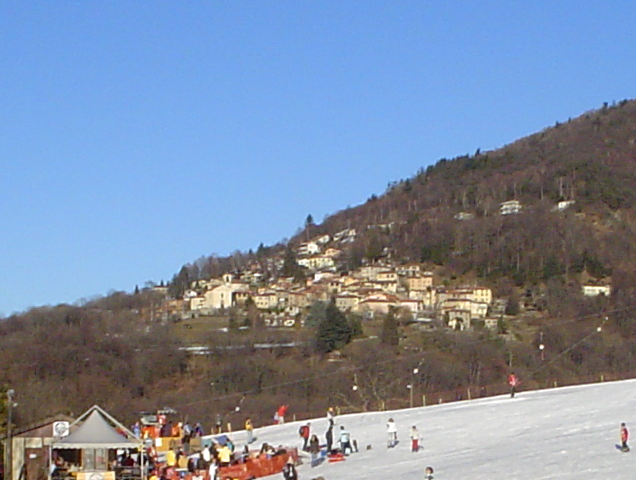
Aranno is a municipality in the district of Lugano in the canton of Ticino in southern Switzerland. Bordering municipalities are Cademario, Iseo, Alto Malcantone, Miglieglia and Novaggio.
In Aranno you can find the "Maglio", the last power hammer of Switzerland. It stopped its activities in 1952.
Aranno is first mentioned in 1335 as Arano.
Cemented into the facade of the Casa Pelli, there are four copies of grave stone fragments (discovered in 1842, originals in the Museo del Malcantone in Curio) with inscriptions in the so-called Alphabet of Lugano.
One unconfirmed source states that the parish church of San Vittore was built in the 17th century on the ruins of an ancient castle. The church was rebuilt in 1815 to its present appearance. Inside the church there are many artistic works from the Malcantone valley.
The local economy was based on agriculture and emigration to other countries for jobs. Further up the valley, there are numerous terraces that support intensive cultivation of vineyards and grain. In 1857, sphalerite, barite and stibnite were discovered and mined for several decades. On the right flank in the area of Miglieglia is the so-called Maglio power hammer. It was built in 1860 in Aranno and is the only functional power hammer with a lever device in Switzerland. It was bought by a preservation society and renovated.
Aranno has an area, as of 1997[update], of 2.72 square kilometers (1.05 sq mi). Of this area, 0.15 km2 (0.058 sq mi) or 5.5% is used for agricultural purposes, while 2.3 km2 (0.89 sq mi) or 84.6% is forested. Of the rest of the land, 0.16 km2 (0.062 sq mi) or 5.9% is settled (buildings or roads), 0.06 km2 (15 acres) or 2.2% is either rivers or lakes and 0.01 km2 (2.5 acres) or 0.4% is unproductive land.
Of the built up area, housing and buildings made up 3.7% and transportation infrastructure made up 1.8%. Out of the forested land, 82.7% of the total land area is heavily forested and 1.8% is covered with orchards or small clusters of trees. Of the agricultural land, 1.5% is used for growing crops and 3.7% is used for alpine pastures. All the water in the municipality is flowing water.
Hub AI
Aranno AI simulator
(@Aranno_simulator)
Aranno
Aranno is a municipality in the district of Lugano in the canton of Ticino in southern Switzerland. Bordering municipalities are Cademario, Iseo, Alto Malcantone, Miglieglia and Novaggio.
In Aranno you can find the "Maglio", the last power hammer of Switzerland. It stopped its activities in 1952.
Aranno is first mentioned in 1335 as Arano.
Cemented into the facade of the Casa Pelli, there are four copies of grave stone fragments (discovered in 1842, originals in the Museo del Malcantone in Curio) with inscriptions in the so-called Alphabet of Lugano.
One unconfirmed source states that the parish church of San Vittore was built in the 17th century on the ruins of an ancient castle. The church was rebuilt in 1815 to its present appearance. Inside the church there are many artistic works from the Malcantone valley.
The local economy was based on agriculture and emigration to other countries for jobs. Further up the valley, there are numerous terraces that support intensive cultivation of vineyards and grain. In 1857, sphalerite, barite and stibnite were discovered and mined for several decades. On the right flank in the area of Miglieglia is the so-called Maglio power hammer. It was built in 1860 in Aranno and is the only functional power hammer with a lever device in Switzerland. It was bought by a preservation society and renovated.
Aranno has an area, as of 1997[update], of 2.72 square kilometers (1.05 sq mi). Of this area, 0.15 km2 (0.058 sq mi) or 5.5% is used for agricultural purposes, while 2.3 km2 (0.89 sq mi) or 84.6% is forested. Of the rest of the land, 0.16 km2 (0.062 sq mi) or 5.9% is settled (buildings or roads), 0.06 km2 (15 acres) or 2.2% is either rivers or lakes and 0.01 km2 (2.5 acres) or 0.4% is unproductive land.
Of the built up area, housing and buildings made up 3.7% and transportation infrastructure made up 1.8%. Out of the forested land, 82.7% of the total land area is heavily forested and 1.8% is covered with orchards or small clusters of trees. Of the agricultural land, 1.5% is used for growing crops and 3.7% is used for alpine pastures. All the water in the municipality is flowing water.
Recent media