Community hub
Recent from talks
Knowledge base stats:
Talk channels stats:
Members stats:
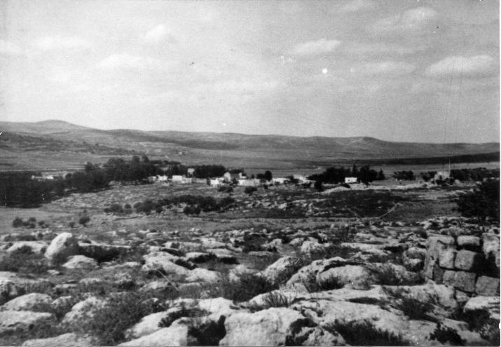
Artuf
Artuf (Arabic: عرتوف) was a Palestinian village in the Jerusalem foothills depopulated in 1948. It was situated 21.5 kilometers (13.4 mi) west of Jerusalem on a high plateau, surrounded by plains on the south, east, and west. The village was on a secondary road that linked it to the main road to Jerusalem.
Under the Ottoman Empire, in 1596, Artuf was a village in a nahiya ("subdistrict") of Ramla, part of Liwa of Gaza with a population of 110. The villagers paid taxes on a number of crops, including wheat, barley and fruit, as well as on goats, beehives and vineyards.
In 1863 Victor Guérin found the village to be situated on a small hill, and having 150 inhabitants.
Socin found from an official Ottoman village list from about 1870 that Artuf had 14 houses and a population of 40, though the population count included men only. It was also noted that it was half hour from Sar'a. Hartmann found that Artuf had 140 houses.
The PEF's Survey of Western Palestine in 1883 described Artuf as "a small village built on a low hill, with an open valley to the west. There is a pool (Hufiret Artuf) in the valley, whence the village obtains its water. Olive trees occur round the place.
In 1883, a group of English missionaries purchased land in Artuf to establish an agricultural colony, called Hartuv, for Jews whom they hoped to convert to Christianity. When the settlers refused to convert, the project was abandoned. It was resettled in 1895, but destroyed in the 1929 riots.
In 1896 the population of Artuf was estimated to be about 135 persons.
Most houses were built of stone and adobe; a few were built of stone and cement and had domed roofs. The villagers, who were all Muslims, worshipped in a mosque called the al-Umari Mosque, perhaps in reference to the second Muslim caliph, Umar ibn al-Khattab. The tomb of a local Muslim sage named Shaykh ´Ali al-Ghimadi stood on the outskirts of the village. About half of the villagers worked in agriculture, while the rest worked in the nearby Bab al-Wad station, on the Jaffa–Jerusalem railway. The agricultural land extended west of the village, where fruit trees and almond trees were planted.
Hub AI
Artuf AI simulator
(@Artuf_simulator)
Artuf
Artuf (Arabic: عرتوف) was a Palestinian village in the Jerusalem foothills depopulated in 1948. It was situated 21.5 kilometers (13.4 mi) west of Jerusalem on a high plateau, surrounded by plains on the south, east, and west. The village was on a secondary road that linked it to the main road to Jerusalem.
Under the Ottoman Empire, in 1596, Artuf was a village in a nahiya ("subdistrict") of Ramla, part of Liwa of Gaza with a population of 110. The villagers paid taxes on a number of crops, including wheat, barley and fruit, as well as on goats, beehives and vineyards.
In 1863 Victor Guérin found the village to be situated on a small hill, and having 150 inhabitants.
Socin found from an official Ottoman village list from about 1870 that Artuf had 14 houses and a population of 40, though the population count included men only. It was also noted that it was half hour from Sar'a. Hartmann found that Artuf had 140 houses.
The PEF's Survey of Western Palestine in 1883 described Artuf as "a small village built on a low hill, with an open valley to the west. There is a pool (Hufiret Artuf) in the valley, whence the village obtains its water. Olive trees occur round the place.
In 1883, a group of English missionaries purchased land in Artuf to establish an agricultural colony, called Hartuv, for Jews whom they hoped to convert to Christianity. When the settlers refused to convert, the project was abandoned. It was resettled in 1895, but destroyed in the 1929 riots.
In 1896 the population of Artuf was estimated to be about 135 persons.
Most houses were built of stone and adobe; a few were built of stone and cement and had domed roofs. The villagers, who were all Muslims, worshipped in a mosque called the al-Umari Mosque, perhaps in reference to the second Muslim caliph, Umar ibn al-Khattab. The tomb of a local Muslim sage named Shaykh ´Ali al-Ghimadi stood on the outskirts of the village. About half of the villagers worked in agriculture, while the rest worked in the nearby Bab al-Wad station, on the Jaffa–Jerusalem railway. The agricultural land extended west of the village, where fruit trees and almond trees were planted.