Community hub
Recent from talks
Knowledge base stats:
Talk channels stats:
Members stats:
Attappadi taluk
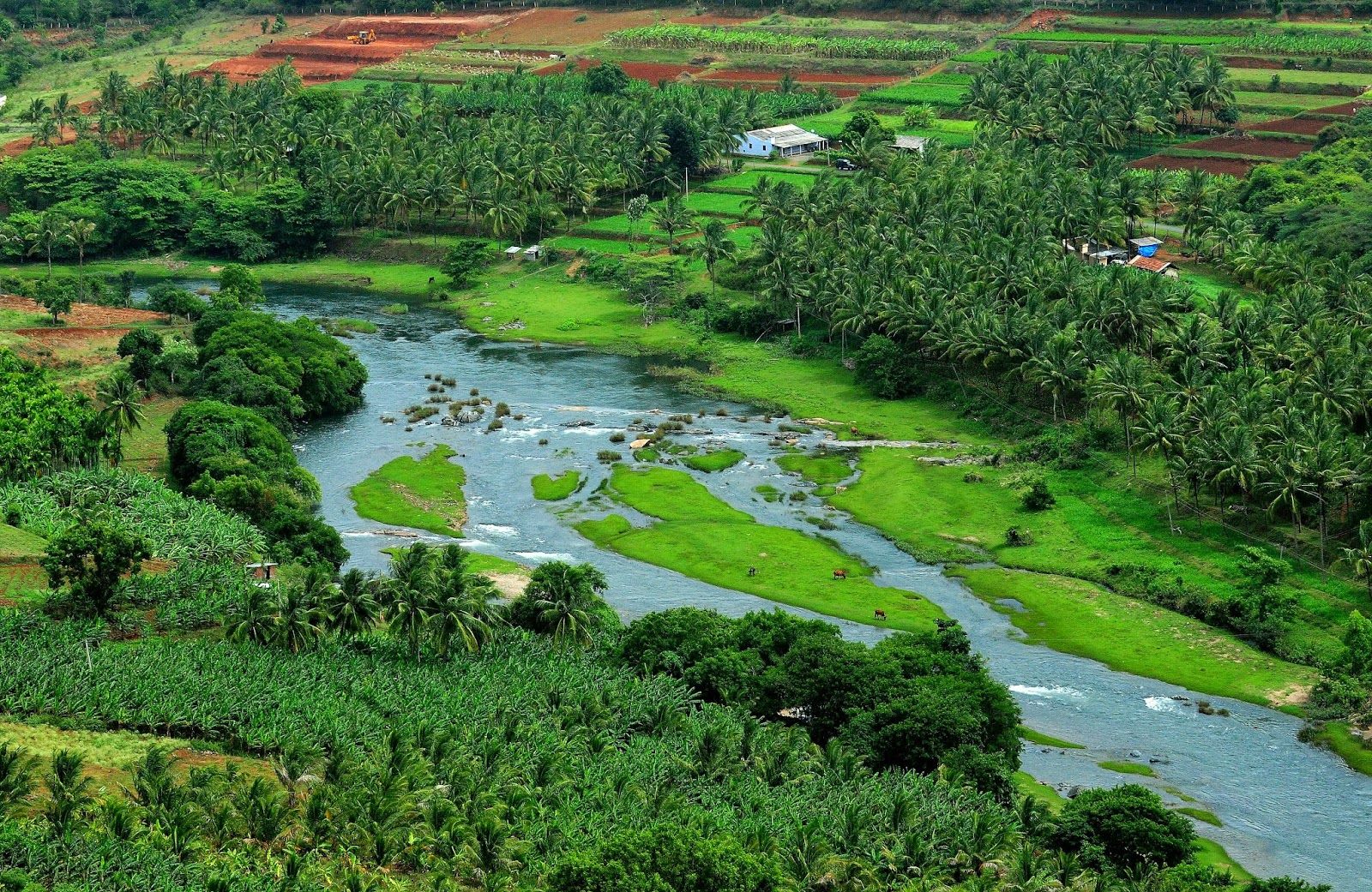
Attappadi (Malayalam: [ɐʈːɐpːaːɖi], HQ:Agali) is the one and only tribal taluk in Kerala state covering an area of 735 km2 (284 sq mi). It was carved out of Mannarkkad taluk in Palakkad district in February 2021. Attappadi Reserve Forest is a protected area comprising 249 km2 of land in the western parts of Attappadi. It is one of the reserved forests and protected forests of India. Attappadi valley in Palakkad district along with the neighbouring Chaliyar valley of the Nilambur region (Eastern Eranad region) in Malappuram district is known for natural Gold fields which are also seen in the other regions of Nilgiri Biosphere Reserve.
Saint George Orthodox Church in Attappady covers the Malankara Orthodox Christians in the area. This parish is under the Diocese of Malabar of the Malankara Orthodox Syrian Church.
Mannarkkad and Attappadi were parts of Valluvanad Swaroopam dynasty in the medieval period with their headquarters at Angadipuram near Perinthalmanna in the present-day Malappuram district. According to local legends, the last Cheraman Perumal ruler gave a vast extension of land in South Malabar during his journey to Mecca to one of their governors, Valluvakonathiri, and left for pilgrimage. Valluvanad was famous for the Mamankam festivals at Tirunavaya, held once in 12 years and the endless wars against the Zamorin of Calicut.
During the last decades of the eighteenth century, the region came under the control of the vast Kingdom of Mysore. Under British Raj, it was a part of Valluvanad Taluk of Malappuram Revenue Division in Malabar District. Perinthalmanna was the headquarters of the Old Walluvanad Taluk in the British Malabar District. Mannarkkad, along with the towns of Perinthalmanna, Malappuram, Manjeri, and Tirurangadi, was one of the main centres of the Malabar Rebellion of 1921.
Walluvanad Taluk was divided into six Revenue blocks: Mankada, Perinthalmanna, Mannarkkad, Ottapalam, Sreekrishnapuram, and Pattambi. Walluvanad was one of the two Taluks included in the Malappuram Revenue Division (the other being Eranad Taluk) of British Malabar. On 1 November 1957, the Walluvanad Taluk was divided into two: Perinthalmanna Taluk and Ottapalam Taluk. The Revenue blocks of Mankada, Perinthalmanna, and Mannarkkad were included in the Perinthalmanna Taluk, while Ottapalam, Sreekrishnapuram, and Pattambi were transferred to the newly formed Ottapalam Taluk. Later Attappadi Revenue block was separated from Mannarkkad Block. During the formation of Malappuram district on 16 June 1969, the Revenue blocks of Mannarkkad and Attappadi were separated from Perinthalmanna Taluk to form Mannarkkad Taluk.
Later some years, a portion of Karuvarakundu village in Eranad Taluk (now Karuvarakundu is a part of Nilambur Taluk) of Malappuram district was transferred to the Silent Valley area of Attappadi. In February 2021, Attappadi tribal taluk formed by carving out from Mannarkkad taluk.
Attappadi is an extensive mountain valley at the headwaters of the Bhavani River nestled below the Nilgiri Hills of the Western Ghats. It is bordered to the east by Coimbatore district in Tamil Nadu, on the north by the Nilgiris, south by the Palakkad taluk, and on the west by Karimba-I and II, Pottassery-I and II, and Mannarghat revenue villages of Mannarghat taluk of the Palghat District and Ernad taluk of the Malappuram district.
The 249 km2 Attappadi Reserve Forest is an informal buffer zone bordering the Silent Valley National Park to the West. 81 km2 of this forest was separated to become most of the new 94 km2 Bhavani Forest Range which is part of the 147.22 km2 Silent Valley Buffer Zone formally approved by the Kerala Cabinet on 6 June 2007. The Cabinet also sanctioned 35 staff to protect the area and two new forest stations in the Bhavani range at Anavai and Thudukki. The zone is aimed at checking the illicit cultivation of ganja (cannabis), poaching, and illicit brewing in areas adjacent to Silent Valley and help long-term sustainability of the protected area.
Hub AI
Attappadi taluk AI simulator
(@Attappadi taluk_simulator)
Attappadi taluk
Attappadi (Malayalam: [ɐʈːɐpːaːɖi], HQ:Agali) is the one and only tribal taluk in Kerala state covering an area of 735 km2 (284 sq mi). It was carved out of Mannarkkad taluk in Palakkad district in February 2021. Attappadi Reserve Forest is a protected area comprising 249 km2 of land in the western parts of Attappadi. It is one of the reserved forests and protected forests of India. Attappadi valley in Palakkad district along with the neighbouring Chaliyar valley of the Nilambur region (Eastern Eranad region) in Malappuram district is known for natural Gold fields which are also seen in the other regions of Nilgiri Biosphere Reserve.
Saint George Orthodox Church in Attappady covers the Malankara Orthodox Christians in the area. This parish is under the Diocese of Malabar of the Malankara Orthodox Syrian Church.
Mannarkkad and Attappadi were parts of Valluvanad Swaroopam dynasty in the medieval period with their headquarters at Angadipuram near Perinthalmanna in the present-day Malappuram district. According to local legends, the last Cheraman Perumal ruler gave a vast extension of land in South Malabar during his journey to Mecca to one of their governors, Valluvakonathiri, and left for pilgrimage. Valluvanad was famous for the Mamankam festivals at Tirunavaya, held once in 12 years and the endless wars against the Zamorin of Calicut.
During the last decades of the eighteenth century, the region came under the control of the vast Kingdom of Mysore. Under British Raj, it was a part of Valluvanad Taluk of Malappuram Revenue Division in Malabar District. Perinthalmanna was the headquarters of the Old Walluvanad Taluk in the British Malabar District. Mannarkkad, along with the towns of Perinthalmanna, Malappuram, Manjeri, and Tirurangadi, was one of the main centres of the Malabar Rebellion of 1921.
Walluvanad Taluk was divided into six Revenue blocks: Mankada, Perinthalmanna, Mannarkkad, Ottapalam, Sreekrishnapuram, and Pattambi. Walluvanad was one of the two Taluks included in the Malappuram Revenue Division (the other being Eranad Taluk) of British Malabar. On 1 November 1957, the Walluvanad Taluk was divided into two: Perinthalmanna Taluk and Ottapalam Taluk. The Revenue blocks of Mankada, Perinthalmanna, and Mannarkkad were included in the Perinthalmanna Taluk, while Ottapalam, Sreekrishnapuram, and Pattambi were transferred to the newly formed Ottapalam Taluk. Later Attappadi Revenue block was separated from Mannarkkad Block. During the formation of Malappuram district on 16 June 1969, the Revenue blocks of Mannarkkad and Attappadi were separated from Perinthalmanna Taluk to form Mannarkkad Taluk.
Later some years, a portion of Karuvarakundu village in Eranad Taluk (now Karuvarakundu is a part of Nilambur Taluk) of Malappuram district was transferred to the Silent Valley area of Attappadi. In February 2021, Attappadi tribal taluk formed by carving out from Mannarkkad taluk.
Attappadi is an extensive mountain valley at the headwaters of the Bhavani River nestled below the Nilgiri Hills of the Western Ghats. It is bordered to the east by Coimbatore district in Tamil Nadu, on the north by the Nilgiris, south by the Palakkad taluk, and on the west by Karimba-I and II, Pottassery-I and II, and Mannarghat revenue villages of Mannarghat taluk of the Palghat District and Ernad taluk of the Malappuram district.
The 249 km2 Attappadi Reserve Forest is an informal buffer zone bordering the Silent Valley National Park to the West. 81 km2 of this forest was separated to become most of the new 94 km2 Bhavani Forest Range which is part of the 147.22 km2 Silent Valley Buffer Zone formally approved by the Kerala Cabinet on 6 June 2007. The Cabinet also sanctioned 35 staff to protect the area and two new forest stations in the Bhavani range at Anavai and Thudukki. The zone is aimed at checking the illicit cultivation of ganja (cannabis), poaching, and illicit brewing in areas adjacent to Silent Valley and help long-term sustainability of the protected area.