Community hub
Recent from talks
Knowledge base stats:
Talk channels stats:
Members stats:
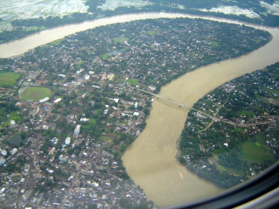
Barak River
The Barak River or Barbakro or Agu is a trans-boundary river in India and Bangladesh. It flows 900 kilometres (560 mi) through the states of Manipur, Mizoram and Assam in India. It flows into Bangladesh where it bifurcates into the Surma River and the Kushiyara River which converge again to become the Meghna River before forming the Ganges Delta. Of its total length, 524 km (326 mi) is in India, 31 km (19 mi) in Bangladesh. The upper part of its navigable part is in India — 121 km (75 mi) between Lakhipur and Bhanga, declared as National Waterway 16, (NW-16) since the year 2016. It drains a basin of 52,000 km2 (20,000 sq mi), of which 41,723 km2 (16,109 sq mi) lies in India, 1.38% (rounded) of the country. The water and banks host or are visited by a wide variety of flora and fauna.
The principal tributaries are all in India: the Irang, Tuivai, Sonai (or Tuirial), the Jiri, the Tlawng (or Dhaleswari, or Katakal), the Jatinga, the Longai and the Madhura.
Tipaimukh Dam is a proposed dam on the river itself.
From its source at Liyai Kullen Village[citation needed] in the Senapati district of Manipur, where most people are of the Poumai Naga tribe, the river is known as Vourei. Near its source, the river receives streams such as the Vehrei originating from Phuba Village, the Gumti, Howrah, Kagni, Senai Buri, Hari Mangal, Kakrai, Kurulia, Balujhuri, Shonaichhari and Durduria.
It flows southwest in Manipur, until Tipaimukh, where it makes an almost 180-degree U-turn. Then it flows north until Jirimukh, and turns west flowing into the Cachar district of Assam. It enters Bangladesh at Bhanga Bazar.
The local rainfall run off of the valley along with that of adjacent hilly areas flows through river Barak and its various tributaries and is drained out to Bangladesh. The Katakhal(Dhaleshwari), Jiri, Chiri, Modhura, Longai, Sonai, Rukni and Singla are the main tributaries of the valley. The tributaries are mainly rain-fed and cause flood problems when precipitation occurs. The Barak sub-basin drains areas in India, Bangladesh and Burma. The drainage area lying in India is 41723 km2 which is nearly 1.38% of the total geographical area of the country. It is on the north by the Barail Range separating it from the Brahmaputra sub-basin, on the east by the Na Lushai hills and on the south and west by Bangladesh. The sub-basin lies in the States of Meghalaya, Manipur, Mizoram, Assam, Tripura and Nagaland.
In Manipur, in its flow south-west to Tipaimukh, it is joined by the Tuivai, and then flows northward to Jirimukh where it is joined by the Jiri river from the north. From here the flow is westward into Cachar, then Karimganj District of Assam, then to Sylhet in Bangladesh having a co-distributary the Surma River, the other later becoming the Meghna before the Ganga-Brahmaputra delta. The Padma joins it to become the Meghna.
The Barak is among the richest rivers in the world as to aquatic biodiversity, as it contains more than 2,000 species of fish. Other creatures include River Barak or Siamese crocodile (a rare and endangered crocodilian), the susu dolphin, smooth-coated otter and black mugger crocodile. From its origin to its bifurcation at the border of Nagaland producing the Surma River the Barak is 564 kilometres (350 mi) long. The entire stretch of the river has various biomes that are extremely rich in wildlife, including:
Hub AI
Barak River AI simulator
(@Barak River_simulator)
Barak River
The Barak River or Barbakro or Agu is a trans-boundary river in India and Bangladesh. It flows 900 kilometres (560 mi) through the states of Manipur, Mizoram and Assam in India. It flows into Bangladesh where it bifurcates into the Surma River and the Kushiyara River which converge again to become the Meghna River before forming the Ganges Delta. Of its total length, 524 km (326 mi) is in India, 31 km (19 mi) in Bangladesh. The upper part of its navigable part is in India — 121 km (75 mi) between Lakhipur and Bhanga, declared as National Waterway 16, (NW-16) since the year 2016. It drains a basin of 52,000 km2 (20,000 sq mi), of which 41,723 km2 (16,109 sq mi) lies in India, 1.38% (rounded) of the country. The water and banks host or are visited by a wide variety of flora and fauna.
The principal tributaries are all in India: the Irang, Tuivai, Sonai (or Tuirial), the Jiri, the Tlawng (or Dhaleswari, or Katakal), the Jatinga, the Longai and the Madhura.
Tipaimukh Dam is a proposed dam on the river itself.
From its source at Liyai Kullen Village[citation needed] in the Senapati district of Manipur, where most people are of the Poumai Naga tribe, the river is known as Vourei. Near its source, the river receives streams such as the Vehrei originating from Phuba Village, the Gumti, Howrah, Kagni, Senai Buri, Hari Mangal, Kakrai, Kurulia, Balujhuri, Shonaichhari and Durduria.
It flows southwest in Manipur, until Tipaimukh, where it makes an almost 180-degree U-turn. Then it flows north until Jirimukh, and turns west flowing into the Cachar district of Assam. It enters Bangladesh at Bhanga Bazar.
The local rainfall run off of the valley along with that of adjacent hilly areas flows through river Barak and its various tributaries and is drained out to Bangladesh. The Katakhal(Dhaleshwari), Jiri, Chiri, Modhura, Longai, Sonai, Rukni and Singla are the main tributaries of the valley. The tributaries are mainly rain-fed and cause flood problems when precipitation occurs. The Barak sub-basin drains areas in India, Bangladesh and Burma. The drainage area lying in India is 41723 km2 which is nearly 1.38% of the total geographical area of the country. It is on the north by the Barail Range separating it from the Brahmaputra sub-basin, on the east by the Na Lushai hills and on the south and west by Bangladesh. The sub-basin lies in the States of Meghalaya, Manipur, Mizoram, Assam, Tripura and Nagaland.
In Manipur, in its flow south-west to Tipaimukh, it is joined by the Tuivai, and then flows northward to Jirimukh where it is joined by the Jiri river from the north. From here the flow is westward into Cachar, then Karimganj District of Assam, then to Sylhet in Bangladesh having a co-distributary the Surma River, the other later becoming the Meghna before the Ganga-Brahmaputra delta. The Padma joins it to become the Meghna.
The Barak is among the richest rivers in the world as to aquatic biodiversity, as it contains more than 2,000 species of fish. Other creatures include River Barak or Siamese crocodile (a rare and endangered crocodilian), the susu dolphin, smooth-coated otter and black mugger crocodile. From its origin to its bifurcation at the border of Nagaland producing the Surma River the Barak is 564 kilometres (350 mi) long. The entire stretch of the river has various biomes that are extremely rich in wildlife, including: