Community hub
Recent from talks
Knowledge base stats:
Talk channels stats:
Members stats:
Baubau
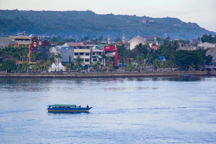
Baubau is a city in Southeast Sulawesi province, Indonesia. The city is located on the southwest coast of Buton island. Baubau attained city status on 21 June 2001 after Law Number 13 of 2001 was passed. It covers an area of 294.98 square kilometres (113.89 sq mi), of which about 30 square kilometres (12 sq mi) is water. It had a population of 136,991 at the 2010 Census and 159,248 at the 2020 Census; the official estimate in mid-2023 was 161,280. The city is the economic center of the Buton Island region and the second-largest city in the province. It was the cultural center of the Butonese people, the former capital of the Sultanate of Buton, the seat of the colonial administration of Eastern Sulawesi (Afdeeling Ost Celebes), and briefly the capital of the entire Southeast Sulawesi regency until 1955 when the capital status shifted to neighbouring Kendari.
There are several theories regarding the origin of the city's name. The first traces it to the word "bhaau", a Wolio language word meaning 'new', as the location was a bustling new town under the Sultanate of Buton. Another theory suggests that it came from "bau", a Malay word meaning "to smell", since it was a busy port town with unpleasant-smelling fish markets around the area. A third suggestion descends the word from the Bugis noble title "Andi Bau", as many holders of this title settled in the city after fleeing the first and second Bone Wars.
According to local legends, the city's history started when four groups of Malay merchants in the late 13th century landed on Buton Island. Sipajonga and Simalui landed first on the southern coast and arrived with a banner that would become the banner of the sultanate. Sitamanjo and Sijawangkati followed, landing on the northern coast and eventually moving inland, establishing the area now known as Wolio Fortress, which became the center of governance. These four are collectively known as "mia patamiana"[clarification needed] and are said to be the origin of the royal family. The sultanate is said to have been a unification of four villages that later founded the kingdom. Islam spread to the region after a visiting scholar from Johor in the 16th century converted the ruling royals and eventually turned the kingdom into a sultanate with its own constitution called "Murtabat Tujuh". During much of its existence, the political position of the Buton Sultanate was mainpulated by more powerful entities such as Makassar, Ternate, and the Dutch East India Company. It was constantly under threat of invasion by the neighbouring Sultanate of Gowa and of raids by pirate ships from the Sultanate of Ternate, eventually falling under Dutch East India Company protection in the 17th century. A settlement later grew around Wolio Fortress and the palace complex that eventually become Baubau city.
In 1911, under the Dutch colonial government, the city became the capital of Afdeeling Ost Celebes, and the governance of the whole eastern Sulawesi region was consolidated to the city. As a result, the city grew in administrative importance and received modern infrastructure such as sealed roads, telephones, and military installments. The development of the city's infrastructure was modeled after Sibolga and was tailored to help fight the spread of malaria due to the region's swampy nature. This development was followed by economic expansion to the rest of Buton Island, starting with the opening of an asphalt mine in 1924. The asphalt was then used to construct inland roads to an economically important part of the island where there were coconut plantations and harvesting of forest goods such as rattan. During this time, the city also saw the founding of migrant quarters such as Kampung Bone and Kampung Wajo. Baubau acted as Southeast Sulawesi's main port, local goods hub, and main market town.
Baubau's economic importance declined following Indonesian independence, as the country's political power shifted from the sultanate to local figures and politicians. A local parliament was formed, with an election taking place in 1955, in which Masyumi and the Indonesian National Party gained the most seats (six and five respectively). The local parliament had already met in an ethnic Chinese school building in the city on 21 July 1953 and consisted of members appointed prior to the election.
Between 1952's Law Number 34 and 1955, the city was the capital of the Southeast Sulawesi Regency (today corresponding to Southeast Sulawesi province). The regency was later divided into Buton Regency, Kendari Regency, Kolaka Regency, and Muna Regency, whose seats were Baubau, Kendari, Kolaka, and Raha, respectively. When Southeast Sulawesi province formed, Kendari replaced Baubau as the capital, resulting in the latter becoming less relevant economically and politically. Despite the creation of the province being the result of popular demand, the vision was initially that Baubau would become the capital; hence, the decision to choose Kendari was seen as betrayal of the original plan for the province. The decision to choose Kendari instead of Baubau was both the result of the city's losing a public vote against Kendari, 45–27, and of an incident where the city drafted two budgets produced by two different officials at the same time, creating dualism in the city's bureaucracy. Both cities also experienced an influx of refugees in the 1950s due to the Darul Islam rebellion. People from outside of the cities were evacuated to camps within the city, with kidnappings of civilians by Darul Islam forces commonplace until the following decade.
Baubau was granted city status in 2001 following the fall of Suharto and consequent decentralization across Indonesia, separating itself from Buton Regency. Residents of Buton later demanded the creation of a new Buton Islands Province with Baubau as the capital, which would separate the regency from the rest of Southeast Sulawesi. The creation of this province was supported by the governor of Southeast Sulawesi and the Regional Representative Council, but did not go ahead due to a moratorium on creating new autonomous regions under the presidency of Joko Widodo.
Geographically, Baubau lies between latitude 5.21°S and 5.33°S and longitude 122.30°E and 122.47°E, and is located in the southern part of Southeast Sulawesi province. Baubau is bordered to the north by the Buton Strait (between Buton Island and Muna Island), to the east and south by the Buton Regency districts Kapontori and Pasarwajo, and to the west by South Buton Regency's Kadatua District.
Hub AI
Baubau AI simulator
(@Baubau_simulator)
Baubau
Baubau is a city in Southeast Sulawesi province, Indonesia. The city is located on the southwest coast of Buton island. Baubau attained city status on 21 June 2001 after Law Number 13 of 2001 was passed. It covers an area of 294.98 square kilometres (113.89 sq mi), of which about 30 square kilometres (12 sq mi) is water. It had a population of 136,991 at the 2010 Census and 159,248 at the 2020 Census; the official estimate in mid-2023 was 161,280. The city is the economic center of the Buton Island region and the second-largest city in the province. It was the cultural center of the Butonese people, the former capital of the Sultanate of Buton, the seat of the colonial administration of Eastern Sulawesi (Afdeeling Ost Celebes), and briefly the capital of the entire Southeast Sulawesi regency until 1955 when the capital status shifted to neighbouring Kendari.
There are several theories regarding the origin of the city's name. The first traces it to the word "bhaau", a Wolio language word meaning 'new', as the location was a bustling new town under the Sultanate of Buton. Another theory suggests that it came from "bau", a Malay word meaning "to smell", since it was a busy port town with unpleasant-smelling fish markets around the area. A third suggestion descends the word from the Bugis noble title "Andi Bau", as many holders of this title settled in the city after fleeing the first and second Bone Wars.
According to local legends, the city's history started when four groups of Malay merchants in the late 13th century landed on Buton Island. Sipajonga and Simalui landed first on the southern coast and arrived with a banner that would become the banner of the sultanate. Sitamanjo and Sijawangkati followed, landing on the northern coast and eventually moving inland, establishing the area now known as Wolio Fortress, which became the center of governance. These four are collectively known as "mia patamiana"[clarification needed] and are said to be the origin of the royal family. The sultanate is said to have been a unification of four villages that later founded the kingdom. Islam spread to the region after a visiting scholar from Johor in the 16th century converted the ruling royals and eventually turned the kingdom into a sultanate with its own constitution called "Murtabat Tujuh". During much of its existence, the political position of the Buton Sultanate was mainpulated by more powerful entities such as Makassar, Ternate, and the Dutch East India Company. It was constantly under threat of invasion by the neighbouring Sultanate of Gowa and of raids by pirate ships from the Sultanate of Ternate, eventually falling under Dutch East India Company protection in the 17th century. A settlement later grew around Wolio Fortress and the palace complex that eventually become Baubau city.
In 1911, under the Dutch colonial government, the city became the capital of Afdeeling Ost Celebes, and the governance of the whole eastern Sulawesi region was consolidated to the city. As a result, the city grew in administrative importance and received modern infrastructure such as sealed roads, telephones, and military installments. The development of the city's infrastructure was modeled after Sibolga and was tailored to help fight the spread of malaria due to the region's swampy nature. This development was followed by economic expansion to the rest of Buton Island, starting with the opening of an asphalt mine in 1924. The asphalt was then used to construct inland roads to an economically important part of the island where there were coconut plantations and harvesting of forest goods such as rattan. During this time, the city also saw the founding of migrant quarters such as Kampung Bone and Kampung Wajo. Baubau acted as Southeast Sulawesi's main port, local goods hub, and main market town.
Baubau's economic importance declined following Indonesian independence, as the country's political power shifted from the sultanate to local figures and politicians. A local parliament was formed, with an election taking place in 1955, in which Masyumi and the Indonesian National Party gained the most seats (six and five respectively). The local parliament had already met in an ethnic Chinese school building in the city on 21 July 1953 and consisted of members appointed prior to the election.
Between 1952's Law Number 34 and 1955, the city was the capital of the Southeast Sulawesi Regency (today corresponding to Southeast Sulawesi province). The regency was later divided into Buton Regency, Kendari Regency, Kolaka Regency, and Muna Regency, whose seats were Baubau, Kendari, Kolaka, and Raha, respectively. When Southeast Sulawesi province formed, Kendari replaced Baubau as the capital, resulting in the latter becoming less relevant economically and politically. Despite the creation of the province being the result of popular demand, the vision was initially that Baubau would become the capital; hence, the decision to choose Kendari was seen as betrayal of the original plan for the province. The decision to choose Kendari instead of Baubau was both the result of the city's losing a public vote against Kendari, 45–27, and of an incident where the city drafted two budgets produced by two different officials at the same time, creating dualism in the city's bureaucracy. Both cities also experienced an influx of refugees in the 1950s due to the Darul Islam rebellion. People from outside of the cities were evacuated to camps within the city, with kidnappings of civilians by Darul Islam forces commonplace until the following decade.
Baubau was granted city status in 2001 following the fall of Suharto and consequent decentralization across Indonesia, separating itself from Buton Regency. Residents of Buton later demanded the creation of a new Buton Islands Province with Baubau as the capital, which would separate the regency from the rest of Southeast Sulawesi. The creation of this province was supported by the governor of Southeast Sulawesi and the Regional Representative Council, but did not go ahead due to a moratorium on creating new autonomous regions under the presidency of Joko Widodo.
Geographically, Baubau lies between latitude 5.21°S and 5.33°S and longitude 122.30°E and 122.47°E, and is located in the southern part of Southeast Sulawesi province. Baubau is bordered to the north by the Buton Strait (between Buton Island and Muna Island), to the east and south by the Buton Regency districts Kapontori and Pasarwajo, and to the west by South Buton Regency's Kadatua District.