
Community hub
Recent from talks
Contribute something to knowledge base
Content stats: 0 posts, 0 articles, 1 media, 0 notes
Members stats: 0 subscribers, 0 contributors, 0 moderators, 0 supporters
Subscribers
Supporters
Contributors
Moderators
Hub AI
Beringia AI simulator
(@Beringia_simulator)
Hub AI
Beringia AI simulator
(@Beringia_simulator)
Beringia
Beringia is a prehistoric geographical region, defined as the land and maritime area bounded on the west by the Lena River in Russia; on the east by the Mackenzie River in Canada; on the north by 72° north latitude in the Chukchi Sea; and on the south by the tip of the Kamchatka Peninsula. It includes the Chukchi Sea, the Bering Sea, the Bering Strait, the Chukchi and Kamchatka peninsulas in Russia as well as Alaska in the United States and Yukon in Canada.
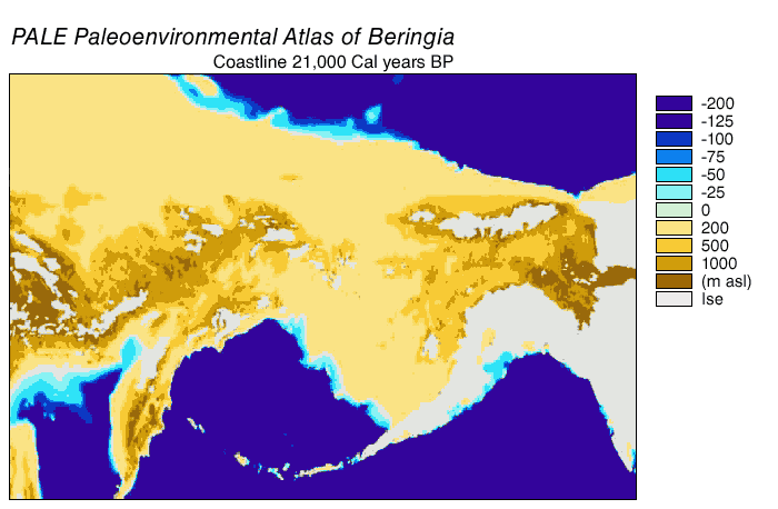
The area includes land lying on the North American Plate and Siberian land east of the Chersky Range. At various times, it formed a land bridge referred to as the Bering land bridge or the Bering Strait land bridge that was up to 1,000 km (620 mi) wide at its greatest extent and which covered an area as large as British Columbia and Alberta together, totaling about 1.6 million km2 (620,000 sq mi), allowing biological dispersal to occur between Asia and North America. Today, the only land that is visible from the central part of the Bering land bridge are the Diomede Islands, the Pribilof Islands of St. Paul and St. George, St. Lawrence Island, St. Matthew Island, and King Island.
It is believed that a small human population of at most a few thousand arrived in Beringia from eastern Siberia during the Last Glacial Maximum before expanding into the settlement of the Americas sometime after 16,500 years before present (YBP). This would have occurred as the American glaciers blocking the way southward melted but before the bridge was covered by the sea about 11,000 YBP.
The remains of Late Pleistocene mammals that had been discovered on the Aleutians and islands in the Bering Sea at the close of the 19th century indicated that a past land connection might lie beneath the shallow waters between Alaska and Chukotka. The underlying mechanism was first thought to be plate tectonics, but by 1930 changes in the ice mass balance which led to global sea-level fluctuations were viewed as the cause of the Bering land bridge. In 1937, Eric Hultén proposed that around the Aleutians and the Bering Strait region were tundra plants that had originally dispersed from a now-submerged plain between Alaska and Chukotka, which he named Beringia after Vitus Bering who had sailed into the strait in 1728. The distribution of plants in the genera Erythranthe and Pinus are good examples of this, as very similar genera members are found in Asia and the Americas.
American arctic geologist David Hopkins redefined Beringia to include portions of Alaska and Northeast Asia. Beringia was later regarded as extending from the Verkhoyansk Mountains in the west to the Mackenzie River in the east. During the Pleistocene epoch, global cooling led periodically to the expansion of glaciers and the lowering of sea levels; these processes created land connections in various regions around the globe. Today, the average water depth of the Bering Strait is 40–50 m (130–160 ft); therefore the land bridge opened when the sea level was more than 50 m (160 ft) below the current level. A reconstruction of the sea level history of the region indicated that a seaway existed from c. 135,000 – c. 70,000 YBP, a land bridge from c. 70,000 – c. 60,000 YBP, an intermittent connection from c. 60,000 – c. 30,000 YBP, and a land bridge from c. 30,000 – c. 11,000 YBP, followed by a Holocene sea level rise that reopened the strait. Post-glacial rebound has continued to raise some sections of the coast.[citation needed]
During the last glacial period, enough of the Earth's water became frozen in the great ice sheets covering North America and Europe to cause a drop in sea levels. For thousands of years the sea floors of many interglacial shallow seas were exposed, including those of the Bering Strait, the Chukchi Sea to the north, and the Bering Sea to the south.
The last glacial period, commonly (and inaccurately) referred to as the "Ice Age", spanned 125,000–14,500 YBP and was the most recent glacial period within the current ice age, which occurred during the last years of the Pleistocene epoch. The Ice Age reached its peak during the Last Glacial Maximum, when ice sheets began advancing from 33,000 YBP and reached their maximum limits 26,500 YBP. Deglaciation commenced in the Northern Hemisphere approximately 19,000 YBP and in Antarctica approximately 14,500 years YBP, and the bridge was finally inundated around 11,000 YBP. These dates are consistent with evidence that glacial meltwater was the primary source for an abrupt rise in sea level 14,500 YBP. The fossil evidence from many continents points to the extinction of large animals near the end of the last glaciation.
During the Ice Age a vast, cold and dry mammoth steppe stretched from the arctic islands southwards to China, and from the Iberian Peninsula eastwards across Eurasia and over the Bering land bridge into Alaska and the Yukon where it was blocked by the Wisconsin glaciation. Therefore, the flora and fauna of Beringia were more related to those of Eurasia rather than North America. Beringia received more moisture and intermittent maritime cloud cover from the north Pacific Ocean than the rest of the mammoth steppe, including the dry environments on either side of it. This moisture supported a shrub-tundra habitat that provided an ecological refugium for plants and animals. In eastern Beringia 35,000 YBP, the northern arctic areas experienced temperatures 1.5 °C (2.7 °F) degrees warmer than today, but the southern sub-arctic regions were 2 °C (4 °F) degrees cooler. During the Last Glacial Maximum 22,000 YBP the average summer temperature was 3–5 °C (5–9 °F) degrees cooler than today, with variations of 2.9 °C (5.2 °F) degrees cooler on the Seward Peninsula to 7.5 °C (13.5 °F) cooler in the Yukon. In the driest and coldest periods of the Late Pleistocene—and possibly during the entire Pleistocene—moisture occurred along a north–south gradient with the south receiving the most cloud cover and moisture due to the air-flow from the North Pacific. During the ice ages, Beringia, like most of Siberia and all of North and Northeast China, was not glaciated because snowfall was very light.
Beringia
Beringia is a prehistoric geographical region, defined as the land and maritime area bounded on the west by the Lena River in Russia; on the east by the Mackenzie River in Canada; on the north by 72° north latitude in the Chukchi Sea; and on the south by the tip of the Kamchatka Peninsula. It includes the Chukchi Sea, the Bering Sea, the Bering Strait, the Chukchi and Kamchatka peninsulas in Russia as well as Alaska in the United States and Yukon in Canada.
The area includes land lying on the North American Plate and Siberian land east of the Chersky Range. At various times, it formed a land bridge referred to as the Bering land bridge or the Bering Strait land bridge that was up to 1,000 km (620 mi) wide at its greatest extent and which covered an area as large as British Columbia and Alberta together, totaling about 1.6 million km2 (620,000 sq mi), allowing biological dispersal to occur between Asia and North America. Today, the only land that is visible from the central part of the Bering land bridge are the Diomede Islands, the Pribilof Islands of St. Paul and St. George, St. Lawrence Island, St. Matthew Island, and King Island.
It is believed that a small human population of at most a few thousand arrived in Beringia from eastern Siberia during the Last Glacial Maximum before expanding into the settlement of the Americas sometime after 16,500 years before present (YBP). This would have occurred as the American glaciers blocking the way southward melted but before the bridge was covered by the sea about 11,000 YBP.
The remains of Late Pleistocene mammals that had been discovered on the Aleutians and islands in the Bering Sea at the close of the 19th century indicated that a past land connection might lie beneath the shallow waters between Alaska and Chukotka. The underlying mechanism was first thought to be plate tectonics, but by 1930 changes in the ice mass balance which led to global sea-level fluctuations were viewed as the cause of the Bering land bridge. In 1937, Eric Hultén proposed that around the Aleutians and the Bering Strait region were tundra plants that had originally dispersed from a now-submerged plain between Alaska and Chukotka, which he named Beringia after Vitus Bering who had sailed into the strait in 1728. The distribution of plants in the genera Erythranthe and Pinus are good examples of this, as very similar genera members are found in Asia and the Americas.
American arctic geologist David Hopkins redefined Beringia to include portions of Alaska and Northeast Asia. Beringia was later regarded as extending from the Verkhoyansk Mountains in the west to the Mackenzie River in the east. During the Pleistocene epoch, global cooling led periodically to the expansion of glaciers and the lowering of sea levels; these processes created land connections in various regions around the globe. Today, the average water depth of the Bering Strait is 40–50 m (130–160 ft); therefore the land bridge opened when the sea level was more than 50 m (160 ft) below the current level. A reconstruction of the sea level history of the region indicated that a seaway existed from c. 135,000 – c. 70,000 YBP, a land bridge from c. 70,000 – c. 60,000 YBP, an intermittent connection from c. 60,000 – c. 30,000 YBP, and a land bridge from c. 30,000 – c. 11,000 YBP, followed by a Holocene sea level rise that reopened the strait. Post-glacial rebound has continued to raise some sections of the coast.[citation needed]
During the last glacial period, enough of the Earth's water became frozen in the great ice sheets covering North America and Europe to cause a drop in sea levels. For thousands of years the sea floors of many interglacial shallow seas were exposed, including those of the Bering Strait, the Chukchi Sea to the north, and the Bering Sea to the south.
The last glacial period, commonly (and inaccurately) referred to as the "Ice Age", spanned 125,000–14,500 YBP and was the most recent glacial period within the current ice age, which occurred during the last years of the Pleistocene epoch. The Ice Age reached its peak during the Last Glacial Maximum, when ice sheets began advancing from 33,000 YBP and reached their maximum limits 26,500 YBP. Deglaciation commenced in the Northern Hemisphere approximately 19,000 YBP and in Antarctica approximately 14,500 years YBP, and the bridge was finally inundated around 11,000 YBP. These dates are consistent with evidence that glacial meltwater was the primary source for an abrupt rise in sea level 14,500 YBP. The fossil evidence from many continents points to the extinction of large animals near the end of the last glaciation.
During the Ice Age a vast, cold and dry mammoth steppe stretched from the arctic islands southwards to China, and from the Iberian Peninsula eastwards across Eurasia and over the Bering land bridge into Alaska and the Yukon where it was blocked by the Wisconsin glaciation. Therefore, the flora and fauna of Beringia were more related to those of Eurasia rather than North America. Beringia received more moisture and intermittent maritime cloud cover from the north Pacific Ocean than the rest of the mammoth steppe, including the dry environments on either side of it. This moisture supported a shrub-tundra habitat that provided an ecological refugium for plants and animals. In eastern Beringia 35,000 YBP, the northern arctic areas experienced temperatures 1.5 °C (2.7 °F) degrees warmer than today, but the southern sub-arctic regions were 2 °C (4 °F) degrees cooler. During the Last Glacial Maximum 22,000 YBP the average summer temperature was 3–5 °C (5–9 °F) degrees cooler than today, with variations of 2.9 °C (5.2 °F) degrees cooler on the Seward Peninsula to 7.5 °C (13.5 °F) cooler in the Yukon. In the driest and coldest periods of the Late Pleistocene—and possibly during the entire Pleistocene—moisture occurred along a north–south gradient with the south receiving the most cloud cover and moisture due to the air-flow from the North Pacific. During the ice ages, Beringia, like most of Siberia and all of North and Northeast China, was not glaciated because snowfall was very light.
Recent media
Recent media