Hubbry Logo
St. Matthew IslandSt. Matthew IslandMain
Open search
St. Matthew Island
Community hub
St. Matthew Island
logo
8 pages, 0 posts
0 subscribers
Be the first to start a discussion here.
Contribute something
St. Matthew Island
St. Matthew Island
from Wikipedia

Key Information

Satellite view of St. Matthew Island
Map

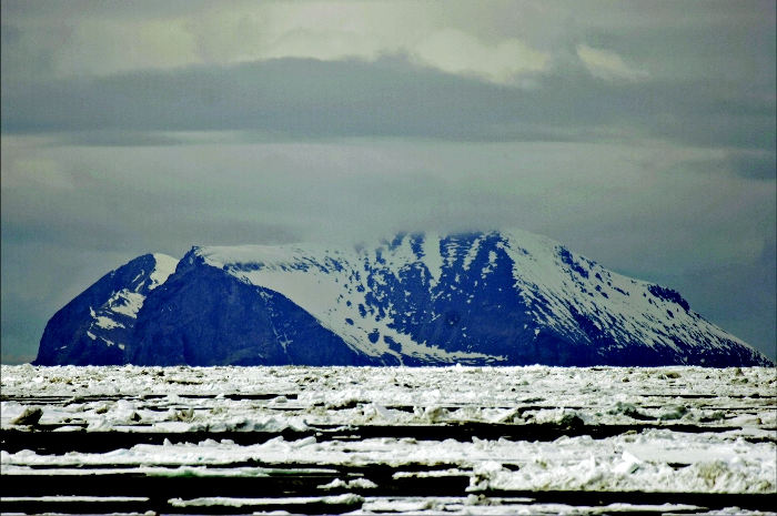
St. Matthew Island (Russian: Остров Святого Матвея, romanizedOstrov Svyatogo Matveya) is an uninhabited, remote island in the Bering Sea in Alaska, 183 miles (295 km) west-northwest of Nunivak Island. The entire island's natural scenery and wildlife is protected as it is part of the Bering Sea unit of the Alaska Maritime National Wildlife Refuge and as the Bering Sea Wilderness.

The island has a land area of 137.857 sq mi (357.05 km2), making it the 44th largest island in the United States. Its most southerly point is Cape Upright which features cliff faces which exceed 1,000 feet (300 m). Similar heights are found at Glory of Russia Cape on the north, and the highest point, 1,476 feet (450 m) above sea level, lies south from the island center.

There is a small island off its northwestern point called Hall Island. The 3.1 miles (5.0 km) wide sound between the two islands is called Sarichef Strait. A small rocky islet called Pinnacle Rock lies 9.3 miles (15.0 km) to the south of Saint Matthew Island.

The United States Coast Guard maintained a staffed LORAN station on the island during the 1940s.

Geology and climate

[edit]

The climatic conditions in the entire Bering Sea Area, according to National Climatic Data Center (1986), is reported as maritime with "considerable wind and cool, humid and cloudy conditions" with mean annual temperature of 37.8 °F (3.2 °C) and annual precipitation of 15.3 in (390 mm) on St. Matthew Island. The geological formation recorded on St. Matthew Island consists of calc-alkaline volcanic rocks of Late Cretaceous and earliest tertiary age with Pergelic Cryaquolls and Pergelic Cryoborolls soil types.[1]

Human habitation

[edit]

The first recorded attempt at settlement occurred in 1809, when a Russian group led by Demid Ilyich Kulikalov, under the aegis of the Russian-American Company, established an experimental outpost.[2]

A 2013 sailing expedition to the island showed that, in spite of the lack of human habitation, extensive areas of beach were heavily contaminated with plastic marine debris, particularly from the fishing industry.[3]

Mammals

[edit]

Presently, Arctic foxes and insular voles[4] are the only mammals resident on the island, though polar bears occasionally visit via pack ice. Notably, St. Matthew Island represents the southern limit of the range of polar bears in the Bering Sea.[5]

Reindeer introduced to St. Matthew Island in 1944 increased from 29 animals at that time to 6,000 in the summer of 1963, a drastic overshoot of the island's carrying capacity causing a crash die-off the following winter to 42 animals. Based on the size of the island, recent estimates put the carrying capacity at about 1,670 animals [Klein, D. R. (n.d.). The Introduction, Increase, and Crash of Reindeer on St. Matthew Island. Retrieved May 25, 2016, from https://web.archive.org/web/20110709032911/http://dieoff.org/page80.htm].

In 1944, 29 reindeer were introduced to the island by the United States Coast Guard to provide an emergency food source. The Coast Guard abandoned the island a few years later, leaving the reindeer. Subsequently, the reindeer population rose to about 6,000 by 1963[6] and then died off in the next two years to 42 animals.[7] A scientific study attributed the population crash to the limited food supply in interaction with climatic factors (the winter of 1963–64 was exceptionally severe in the region).[1] By the 1980s, the reindeer population had completely died out.[2] Environmentalists see this as an issue of overpopulation. For example, ecologist Garrett Hardin cited the "natural experiment" of St. Matthew Island of the reindeer population explosion and collapse as a paradigmatic example of the consequences of overpopulation in his essay An Ecolate View of the Human Predicament.[8]

Birds

[edit]

Despite its high latitude, St. Matthew Island contains significant populations of endemic and migratory birds. In fact, the Department of the Interior has called the island "one of the richest seabird nesting colonies in the world", with over 5 million seabirds nesting during breeding season.[9] Over 140 different species of birds have been identified on the island.[10] The island, along with its small satellites Hall Island and Pinnacle Rock, contains the entire breeding range of McKay's bunting.[11] Additionally, a subspecies of rock sandpiper (Calidris ptilocnemis ptilocnemis) and a subspecies of gray-crowned rosy finch (Leucosticte tephrocotis umbrina) breed only on the island and the nearby Pribilof Islands.[10][11] Both McKay's bunting and Calidris ptilocnemis ptilocnemis, with their restricted breeding ranges, are among the rarest birds in North America, making their preservation among the top priorities for conservation groups.[10]

Fish

[edit]

There are two major lakes on the island, North Lake and Big Lake. The lakes contain a greater number of fish species (at least 5) than other nearby islands.[12]

Lichen

[edit]

Lichen studies were conducted on the island in the 1990s to prepare a list of lichens with their habitat, composition and distribution pattern. These studies were considered important for characterizing the eating habits of caribou and air quality. The vegetation of the islands has been classified as wet, moist and alpine tundra, based on landforms and drainage patterns. The plant communities were attributed to five categories. In the area of rock rubble fields and high ridges the vegetation was mainly crustose lichens. Among the 148 lichen species of the islands, 125 showed the Arctic–alpine geographic distribution, 74 boreal, 18 were coastal, 9 amphi-Berengian and 41 widespread, with many species falling into more than one category. The lichen diversity was characterized by wide-ranging Arctic–alpine and boreal species; it was evaluated as luxuriant that was linked to reindeer species disappearing from the area.[1]

[edit]

The island serves as a location that the characters travel to in the 2025 film Mission: Impossible - The Final Reckoning, though the scenes in the movie that take place there were actually shot in Svalbard, Norway.[citation needed]

See also

[edit]

Further reading

[edit]

References

[edit]
Revisions and contributorsEdit on WikipediaRead on Wikipedia
from Grokipedia
St. Matthew Island is a remote, uninhabited in the , approximately 300 kilometers west of mainland and part of the Alaska Maritime National Wildlife Refuge, renowned for its rugged landscape and the ecological of an introduced population that exploded and then collapsed to . The island spans 357 square kilometers (138 square miles), measuring roughly 52 kilometers in length and 6 kilometers in width, with a hilly rising to a maximum of 457 meters at Cape Upright, featuring steep cliffs, stream-fed valleys, and numerous ponds and lakes. Its consists primarily of subaerial volcanic rocks, dating from 65 to 77 million years ago, including high-alumina basalts to rhyolites intruded by early Tertiary granodiorite, representing a southeastern extension of the ancient Okhotsk-Chukotsk along the Pacific margin. The landscape is characteristic of arctic tundra, dominated by low-lying vegetation such as dwarf shrubs, lichens, and sedges in lush lowlands, transitioning to sparser cover on higher, windswept ridges. Human history on the island is sparse due to its isolation, with discovery attributed to Lieutenant Synd between 1764 and 1768, who named it after Saint Matthew, followed by a sighting by Captain in 1778. Early 19th-century Russian and Aleut expeditions briefly hunted there from 1810 to 1811, but the animals were extirpated by the 1890s; subsequent uses included early 20th-century fox trapping by Nome residents, who constructed cabins, and military installations, including a (1942–1943) and a Loran-A site (1943–1947) staffed by up to 23 personnel. In 1944, 29 reindeer from were introduced as an emergency food source for personnel, leading to a population surge to 6,000 by 1963—a of approximately 43 animals per square mile—before a catastrophic decline to 42 survivors by 1966 due to overgrazing-induced exacerbated by severe winters, with the last individuals dying by the mid-1980s. Ecologically, the island supports a rich avifauna with over one million seabirds nesting in colonies, including species like auklets and murres, alongside six resident land bird species, arctic foxes, insular voles, and visiting marine mammals such as Steller sea lions, walruses, and whales; four species of inhabit its ponds. Archaeological surveys in 1997 and 2002 revealed limited prehistoric evidence, including a Thule-like house pit and dated 350–430 years , as well as historic sites from and eras, underscoring the island's minimal human footprint. Today, its extreme remoteness—over 24 hours by boat from the nearest settlements—preserves it as a pristine , occasionally visited by ecotourists for and , while serving as a key site for studying climate impacts on ecosystems, with recent research (as of 2024) including documentation of rare bird breeding and paleoenvironmental analyses of glacial refugia.

Geography

Location and extent

St. Matthew Island is situated in the central at coordinates 60°24′31″N 172°43′12″W. It lies approximately 183 miles (295 km) west-northwest of and over 200 miles from the mainland, positioning it roughly halfway between mainland and across the . This extreme isolation makes it the most remote location in and one of the most inaccessible places in the United States. The island spans 128 square miles (331 km²), measuring 31.7 miles in length and up to 4 miles in width. Its elongated, narrow shape features steep cliffs along much of the coastline, contributing to its rugged profile. Associated features include the smaller Hall Island, covering 2.2 square miles and located 0.7 miles offshore to the northwest, as well as the tiny Pinnacle Rock. The entire island group forms part of the Unit of the Maritime , established in 1980 under the Alaska National Interest Lands Conservation Act. There is no permanent human habitation or on St. Matthew Island, and access is limited to or during the brief summer period when retreats. The harsh environmental conditions, including frequent fog and storms, further restrict visitation, emphasizing the island's status as Alaska's most remote outpost.

Geology

St. Matthew Island's geology is dominated by volcanic rocks formed during the to early Tertiary periods, comprising approximately 500 meters of subaerial calc-alkaline volcanic sequences that range from high-alumina to rhyolite and . These rocks represent a southeastward extension of the Okhotsk-Chukotsk , a major and early Tertiary arc system along the Pacific margin of , with the island's assemblages intruded by early Tertiary granodiorite dated to about 61 million years ago via K-Ar methods. The volcanic activity contributed to the island's rugged terrain, including steep coastal cliffs and a central plateau. The island's highest elevation reaches 457 meters at Cape Upright, featuring sheer cliffs that drop dramatically to the sea, while the interior consists of a relatively flat plateau. Soils are primarily permafrost-dominated, with low nutrient content derived from weathered volcanic , supporting sparse herbaceous cover without tree growth. These conditions limit to tundra species dominated by sedges, grasses, and lichens adapted to the cold. Associated geomorphic features include freshwater lakes such as North Lake and Big Lake, which occupy depressions in the volcanic terrain likely formed by or caldera-like structures from ancient eruptions. Recent paleoclimate has utilized oxygen analyses (δ¹⁸O) from and lake sediments on the island, revealing a 5,500-year record of environmental variability in the region, including fluctuations in winter extent linked to insolation and atmospheric patterns. This , derived from macrofossil assemblages and cellulose , underscores the island's role in reconstructing climate dynamics without direct evidence of recent tectonic activity.

Climate

St. Matthew Island features a maritime influenced by the , characterized by frequent fog, high winds averaging 20-25 knots, and variable weather patterns that contribute to its isolation and environmental challenges. The annual mean temperature is approximately 37.8°F (3.2°C). Annual precipitation totals about 15.3 inches (39 cm), primarily as rain during summer months and snow in winter, supporting limited vegetation while exacerbating in high winds. Extreme weather includes severe winters with blizzards and strong storms, as evidenced by record snow accumulations in the 1960s that impacted wildlife. Recent trends show delayed sea ice formation, altering coastal dynamics and wildlife migrations. Permafrost thaw is accelerating, with 2024 recording the second-highest temperatures on record across Alaskan monitoring sites, influencing ground stability and tundra cycles without directly affecting the island's rocky geology.

History

Early discovery and exploration

St. Matthew Island, located in the remote , was first sighted by Russian explorers in the mid-18th century. Lieutenant Ivan Synd of the discovered the island in 1766 during a surveying expedition and named it after the apostle Matthew, honoring the Orthodox saint's day associated with the sighting. Earlier attributions to Vitus Bering's 1741 expedition have been noted in some accounts, but primary records confirm the 1766 Russian discovery as the initial European contact. In 1778, Captain approached the island during his third voyage, believing it to be previously undiscovered; he attempted to rename it Gores Island after one of his officers but the original designation prevailed. Archaeological evidence suggests limited pre-contact use of the island by , particularly ancestors of the and . A Thule-era house pit, dating to approximately 1650 AD, indicates brief seasonal occupation, likely for hunting marine mammals such as , as evidenced by associated artifacts like a lichen-crusted whale jawbone. This site, excavated in the late , represents one of the few traces of human activity on the island before European arrival, with no indications of permanent settlements due to the harsh environment and isolation. Oral histories from nearby communities also reference occasional voyages to the outer islands for resource exploitation, though direct ties to St. Matthew remain tentative. The island's remoteness, over 300 miles from the Alaskan mainland, likely restricted such visits to skilled seafarers using umiaks for and . In the early , residents from Nome occasionally visited for trapping, constructing temporary cabins. , once abundant (hundreds observed in 1874), were extirpated by the 1890s through Russian and American hunting. During , prior to the LORAN station, a temporary operated from 1942 to 1943. The first recorded European settlement attempt occurred in 1809, when a expedition led by Demid Ilyich Kulikov (later I. Arkhimandritov after Kulikov's death) overwintered on the island with approximately 20 Russians and Unangan (Aleut) hunters to trap arctic foxes, collect walrus tusks, and hunt for the fur trade. The party endured extreme conditions, including severe storms, , and predation by , resulting in more than half dying primarily from ; the survivors returned to Unalaska in 1810, abandoning the site due to its uninhabitability. Throughout the 19th century, the island saw sporadic visits from American and British whaling ships, which used it as a navigational landmark while pursuing bowhead and right whales in the ; whalers referred to the archipelago as the "Bear Islands" due to its population. In the late 19th century, U.S. expeditions conducted the first systematic mapping of St. Matthew Island as part of broader Bering Sea surveys. Naturalist Henry W. Elliott and Lieutenant Washburn Maynard visited in August 1874 during a U.S. Revenue Cutter Service mission to assess fur seal populations and telegraph cable routes, producing detailed sketches and descriptions of the island's topography, including its prominent ridgeline and coastal features. Their reports highlighted the island's abundant seabird colonies, though the remote location and logistical challenges prevented further exploration. These explorations established St. Matthew's coordinates and confirmed its status as an unclaimed, uninhabited outpost, contributing to early U.S. claims in the region following the 1867 Alaska Purchase.

Human habitation and modern use

During , the established a (Long Range Aid to Navigation) radio station on the southwestern coast of St. Matthew Island in 1943 to aid maritime navigation across the . The facility was commissioned in and disestablished in October 1946, after which it was fully abandoned by a Coast Guard work party in May 1949 due to severe deterioration from the island's extreme weather. The station temporarily housed about 19 to 24 personnel, including one officer and enlisted technicians, cooks, and medics, who faced isolation, 8-meter snow drifts, and months-long sea ice entrapment. In the post-war period, the remnants of the station—such as rusted Quonset huts, concrete foundations, and fuel barrels—persist on the landscape, gradually reclaiming by and . Scientific expeditions have provided the primary human presence since the , with the U.S. Geological Survey conducting key surveys, including a 1971 reconnaissance to map volcanic rocks and assess tectonic features. Additional USGS efforts in the involved satellite-based monitoring of and changes. St. Matthew Island confronts contemporary environmental pressures, notably the high accumulation of plastic marine debris on its beaches, which has become ubiquitous since the late compared to pre-1960s conditions free of such . Designated as part of the Maritime National Wildlife Refuge in , the island's 300 square kilometers are fully protected to preserve its pristine ecosystems, prohibiting any development or resource extraction. The U.S. Fish and Wildlife Service oversees management, restricting access to infrequent monitoring and research visits while barring and permanent settlement. From onward, paleoclimate research has featured prominently in expeditions, exemplified by of a 2012 peat core sample that, in a study, documented the Bering Sea's winter at its lowest extent in 5,500 years due to rising CO2 and insolation. The island supports no permanent human population, emphasizing its role as a remote, minimally disturbed site for scientific inquiry.

Reindeer introduction and crash

In 1944, the U.S. introduced 29 yearling (Rangifer tarandus) to St. Matthew Island in the as a potential emergency food source for , consisting of 24 females and 5 males released on 20. The island's abundant , which covered about 80% of the landscape and supported high reproductive rates with low initial mortality, allowed the population to expand rapidly without predators or hunting pressure. The herd grew exponentially, reaching approximately 1,350 animals by summer 1957 and peaking at around 6,000 by summer 1963, reflecting an average annual finite population growth rate of λ = 1.32 over 19 years. This surge overshot the island's estimated carrying capacity of 5 to 10 animals per square mile, leading to overgrazing that depleted winter forage reserves, though pre-crash calf-to-cow ratios remained stable at about 60:100, indicating no immediate reproductive decline. The then experienced a catastrophic 99% die-off, plummeting from 6,000 in to just 42 survivors—mostly females—by summer 1966, primarily due to exacerbated by the severe winter of –1964, which brought deep snow cover that prevented access to remaining lichens. The remnant herd dwindled further, with the last female dying in 1981 and the population declared extinct by the 1980s; U.S. Geological Survey surveys confirmed no surviving as of 2024. A 2005 reevaluation of historical data affirmed that the crash was abrupt and concentrated in the –1964 winter rather than gradual, attributing it mainly to rather than forage exhaustion alone, as evidence showed sustained productivity until the event. This event has served as a seminal in , illustrating the risks of introductions on islands with limited resources, as detailed in a 1968 report by wildlife biologist David R. Klein; no subsequent reintroduction efforts have been attempted. The also contributed to long-term shifts in native , though recovery has been slow.

Ecology

Flora

St. Matthew Island's flora is characteristic of arctic , featuring low-growing herbaceous plants adapted to harsh, windswept conditions with no trees or shrubs exceeding 1 foot in height. The ecosystem is dominated by sedges such as Carex aquatilis and glareosa, grasses including Dupontia fisheri and , and various forbs like Pedicularis kanei and Rumex arcticus. This prostrate dwarf-shrub supports a low-diversity shaped by , strong winds, and short growing seasons, with vascular plants documented in collections. Lichens play a pivotal role as primary producers and ground cover, with 139 taxa reported across St. Matthew and neighboring St. Paul Islands, of which St. Matthew hosts a richer assemblage of arctic-alpine species such as Cetraria islandica and Cladina spp.. These lichens, including boreal forms like Cetraria delisei and Sphaerophorus globosus, historically covered up to 75% of the ground in some areas prior to disturbances, providing essential winter in this nutrient-poor environment. Non-vascular components, including mosses and liverworts, contribute to the overall diversity of bryophytes and lichens, enhancing stability and moisture retention. Aquatic plants thrive in the island's numerous lakes and ponds, supporting localized communities amid the otherwise xeric . Plant diversity remains limited by the island's isolation and extreme climate, with vascular species like arctic willow (Salix arctica) and cotton grasses ( and russeolum) forming resilient mats that dominate lowlands and valleys. A U.S. Geological Survey inventory in the early 2000s highlighted the dominance and vulnerability, while paleobotanical analyses of lake sediments reveal continuity of assemblages from the , underscoring long-term stability. Following severe overgrazing by introduced in the mid-20th century, which reduced cover to less than 13%, vegetation has shown gradual resilience, with vascular plants increasing and lichens recovering to about 12% of pre-disturbance by the early 2000s, aided by the absence of herbivores since the 1960s population crash. By the 2020s, the exhibits signs of stabilization, though full lichen recovery is delayed by warming trends.

Mammals

St. Matthew Island's mammalian fauna is characterized by low diversity, a consequence of its extreme isolation in the northern , over 300 kilometers from the Alaskan mainland. The only native terrestrial mammals are the (Vulpes lagopus), a year-round resident adapted to the harsh environment, and the insular vole (Microtus abbreviatus), an endemic species restricted to St. Matthew and adjacent Hall Island. The insular vole, also known as the St. Matthew Island vole, inhabits moist lowlands and lower slopes, where it burrows in well-vegetated rocky outcroppings and cycles its population in irruptive patterns linked to vegetation abundance, a common trait among microtine rodents on isolated islands. Arctic foxes, meanwhile, rely on voles and seabirds as primary prey, their dense fur and seasonal pelage change enabling survival in the island's subarctic climate with minimal shelter. This limited prey base and remoteness contribute to the absence of larger herbivores since the collapse of the introduced reindeer population. Occasional mammalian visitors include polar bears (Ursus maritimus), which arrive via winter sea ice but do not establish breeding populations, marking the island as the southern extent of their Bering Sea range; marine mammals such as seals and otters do not colonize the land. Population dynamics for native species are driven by prey availability, with vole numbers fluctuating cyclically and fox densities responding accordingly. The Alaska Maritime National Wildlife Refuge conducts periodic surveys during expeditions, with assessments in the 2010s documenting active fox dens and vole presence, indicating relative stability despite environmental pressures. Key threats to these mammals include competition from colonizing red foxes (Vulpes vulpes), which have displaced arctic foxes through multiple long-distance dispersals over , and broader climate change impacts that reduce extent and frequency, limiting polar bear access. These changes, observed in ecosystems, indirectly affect fox and vole populations by altering prey dynamics and habitat conditions.

Birds

St. Matthew Island, part of the Maritime National Wildlife Refuge, supports a diverse avifauna with approximately 140 species of birds recorded across its remote location. This underscores the island's role as a critical , particularly for seabirds, with over 1.5 million breeding individuals annually contributing to its ecological significance. The island's cliffs, , and coastal areas provide essential nesting and foraging grounds, attracting species from both Pacific and migratory routes. Among the key avian groups are alcids, which dominate the breeding seabird populations. Least auklets (Aethia pusilla) and horned puffins (Fratercula corniculata) form large colonies on steep sea cliffs, with estimates indicating hundreds of thousands of individuals for species like northern fulmars (Fulmarus glacialis) and common murres (Uria aalge). , including the (Larus hyperboreus), are common breeders, nesting on rocky shores and with populations around 2,000 pairs observed in historical surveys. Shorebirds, such as the rock sandpiper (Calidris pugnax), also thrive, utilizing coastal lowlands for breeding; the nominate is largely restricted to St. Matthew and nearby Hall Island. The island hosts notable endemic species that highlight its unique biogeographic position. McKay's bunting (Plectrophenax hyperboreus), a small , breeds exclusively on St. Matthew and Hall Islands, with its global population estimated at 19,000–31,000 individuals as of the early , though recent surveys indicate a decline to approximately 19,500 by 2023 due to and predation pressures. These endemics nest in rock crevices and , with McKay's bunting favoring coastal lowlands for cavity nesting. Breeding activity peaks in summer, transforming the island into a major hub for avifauna, where migrants arrive to exploit the productive marine waters. Cliffs serve as primary sites for colonial nesting, while supports ground-nesters like buntings and . In winter, the island is largely depopulated, with only hardy raptors, such as gyrfalcons (Falco rusticolus), remaining to hunt over the icy landscape. Conservation efforts are bolstered by the island's designation within the Alaska Maritime National Wildlife Refuge since 1980, protecting its avifauna from human disturbance. Threats include , which delays formation and disrupts migrant timing, as well as predation by Arctic foxes on eggs and chicks. Surveys in 2019 documented stable overall populations and added several to the island's list, indicating resilience despite these pressures.

Fish

The freshwater fish communities of St. Matthew Island are confined to its two primary lakes, North Lake and Big Lake, which support a low-diversity assemblage adapted to the cold, oligotrophic conditions of the environment. These lakes, characterized by low nutrient levels and perennial ice cover for much of the year, host at least five resident species, including Dolly Varden char (Salvelinus malma malma), threespine (Gasterosteus aculeatus), ninespine (Pungitius pungitius), (Dallia pectoralis), and coastrange (Cottus aleuticus). Dolly Varden, the largest of these, reaches up to 30 cm in length and inhabits both lacustrine and stream-connected habitats, while the sticklebacks and sculpin dominate shallower, vegetated nearshore areas; , tolerant of low oxygen, persists in deeper, hypoxic zones. No major anadromous fish runs occur on the island due to the absence of suitable spawning streams connecting to the sea, limiting colonization and . These fish play a key ecological role as prey for seabirds, such as loons and diving ducks, and occasional mammalian predators like arctic foxes, contributing to the island's limited trophic web despite the overall paucity of aquatic vertebrates. The cold temperatures (typically below 10°C in summer) and oligotrophic nature restrict growth rates and biomass, resulting in sparse populations that are vulnerable to events like prolonged ice cover. In the surrounding Bering Sea waters, marine fish communities exhibit greater diversity, with commercially and ecologically significant species including multiple salmon (Oncorhynchus spp., such as pink, chum, and sockeye), Pacific cod (Gadus macrocephalus), and Pacific halibut (Hippoglossus stenolepis). Nearshore areas around the island support forage fish like Pacific herring (Clupea pallasii), capelin (Mallotus villosus), and sand lance (Ammodytes hexapterus), which are primary prey for seabirds breeding on the island's cliffs. Limited surveys of island fish date to the mid-20th century, with collections in 1954 documenting four species (Dolly Varden, threespine and ninespine sticklebacks, and ) in streams and the largest lake. More comprehensive sampling in 2012 confirmed the five-species assemblage in both North and Big Lakes using minnow traps, revealing no significant contaminants but highlighting the persistence of these communities. Broader monitoring in the 2020s indicates warming-driven shifts in marine distributions, with species like moving northward and abundances fluctuating due to reduced and altered productivity, though no recent island-specific data exist. Emerging threats to these communities include , which reduces carbonate availability and impairs shell formation in prey like pteropods, indirectly affecting webs in the . , including ingested by , has increased since the 1980s and poses risks to marine stocks through and habitat degradation around the remote island shores.

Cultural and scientific significance

St. Matthew Island has been depicted in popular media as a symbol of extreme isolation and ecological caution, often highlighting its remoteness in the as a backdrop for adventure and human vulnerability. In the 2025 Mission: Impossible – The Final Reckoning, the island serves as a key plot location where characters, including a reclusive CIA analyst, confront high-stakes threats amid its unforgiving terrain; scenes set there were filmed in the landscapes of , , to replicate the isolated environment. Literature and journalistic accounts frequently portray the island as one of America's most remote and inhospitable places, emphasizing its inaccessibility to underscore themes of and natural limits. A 2020 Smithsonian Magazine article describes it as "the most remote place in ," marooned over 300 kilometers from the mainland and accessible only by multiday boat journeys in treacherous waters. Similarly, Hakai Magazine's 2020 feature labels it "the most remote place in ," evoking its mystique as an unconquerable that defies . These portrayals draw on the island's lack of permanent inhabitants to symbolize broader ideas of isolation and the boundaries of . The island's reindeer population crash has inspired creative works that use it as a for and environmental collapse. Cartoonist Stuart McMillen's 2011 comic St. Matthew Island narrates the introduction of 29 in 1944 and their rapid boom to nearly 6,000 before a near-total die-off by 1966, presenting the event as a for and ; the work has been highlighted in environmental media for its illustrative power. Such depictions in media often reference the story to explore adventure tropes, like marooned explorers facing nature's harsh indifference, reinforcing the island's cultural role as a cautionary emblem of human overreach.

Scientific importance

St. Matthew Island has served as a key site for research, particularly through the study of the introduced herd, which exemplifies resource overshoot and in isolated ecosystems. This event, documented in David R. Klein's seminal analysis spanning field observations from 1959 to 1968, highlighted food supply interacting with climatic factors as the primary regulatory mechanism, influencing models of worldwide. A 2010 reexamination confirmed the 1963–1964 winter die-off as the critical point, driven by from depleted winter rather than or predation, with no surviving observed since the 1980s, marking the herd's . Biodiversity studies on the island emphasize its role as a refuge for endemic amid isolation. U.S. Geological Survey inventories identified 139 taxa on St. Matthew and adjacent St. Paul Islands, underscoring the community's vulnerability to overgrazing, as evidenced by post-reindeer recovery monitoring showing slow regeneration of dominant like Cetraria and . The McKay's bunting (Plectrophenax hyperboreus), an endemic bird breeding exclusively on St. Matthew and Hall Islands, has been the focus of genetic and demographic research; analyses confirm its distinction from the (P. nivalis), while 2018 surveys (published 2023) estimate a total of approximately 19,500 individuals, representing a 38% decline from ~31,600 individuals in 2003 due to habitat shifts and climate pressures. Similarly, the insular vole (Microtus abbreviatus), a evolved from mainland ancestors following post-glacial isolation around 11,000 years ago, demonstrates rapid in vocalization and morphology; genetic studies, including analysis, show it is closely related to M. miurus, with some debate on its status as a distinct . Paleoclimate investigations leverage the island's undisturbed sediments to reconstruct environmental history over millennia. A 2020 Science Advances study analyzed a 1.45-meter core from a fen near North Lake, spanning 5,500 years, revealing winter sea ice extent as highly sensitive to winter insolation and atmospheric CO₂; ice cover decreased progressively through the , with modern levels 20–30% lower than mid- peaks, informed by cellulose oxygen isotopes (δ¹⁸O) and . δ18O=18O/16Osample18O/16Ostandard18O/16Ostandard×1000\delta^{18}O = \frac{{^{18}O/^{16}O}_{sample} - {^{18}O/^{16}O}_{standard}}{{^{18}O/^{16}O}_{standard}} \times 1000 This equation, applied to peat samples, tracks precipitation and temperature variability, showing warmer, wetter conditions post-4,000 years ago. Complementary permafrost and stable isotope data from island lakes further document regional shifts, including amplified Bering Sea warming since 1980, updating earlier 1986 National Climatic Data Center records that underestimated recent trends with average annual temperatures now 1–2°C higher based on 2020–2025 regional proxies. Additional research encompasses anthropological and . A anthropological synthesis outlined prehistoric human land use, including possible Thule occupations evidenced by lithic artifacts and faunal remains including fox bones, dated approximately 350–430 years BP (ca. AD 1520–1600), integrated with oral histories from Siberian communities. U.S. Fish and Wildlife Service and USGS collaborations from 2020 to 2025, building on 2012 expeditions, have conducted ongoing climate monitoring through sediment coring and vegetation surveys at sites like North Lake, addressing gaps in outdated baselines while confirming no recovery.

References

Add your contribution
Related Hubs
Contribute something
User Avatar
No comments yet.