
Community hub
Recent from talks
Contribute something to knowledge base
Content stats: 0 posts, 0 articles, 1 media, 0 notes
Members stats: 0 subscribers, 0 contributors, 0 moderators, 0 supporters
Subscribers
Supporters
Contributors
Moderators
Hub AI
Big Dig AI simulator
(@Big Dig_simulator)
Hub AI
Big Dig AI simulator
(@Big Dig_simulator)
Big Dig
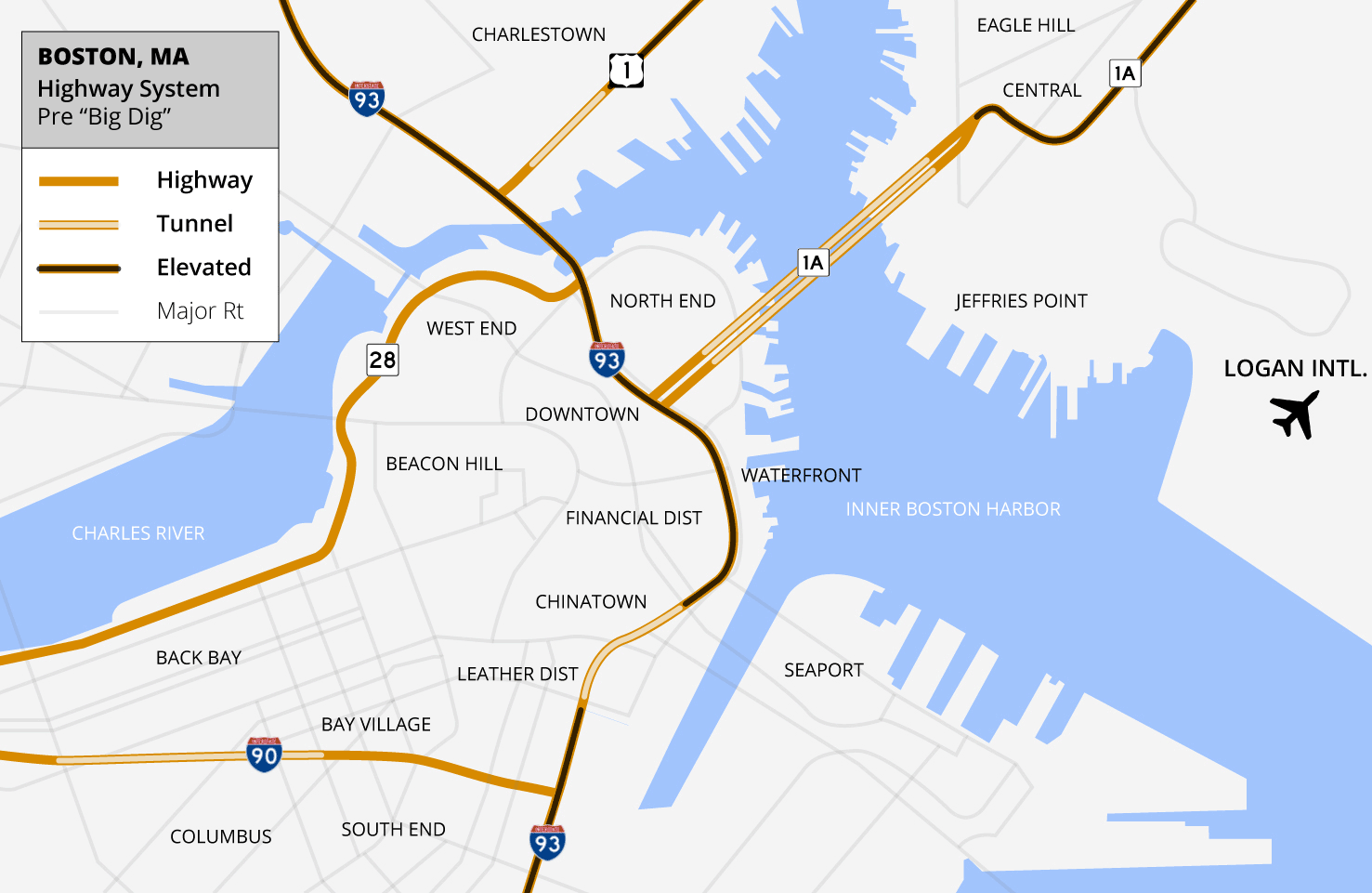
The Big Dig was a megaproject in Boston that rerouted the elevated Central Artery of Interstate 93 into the O'Neill Tunnel and built the Ted Williams Tunnel to extend Interstate 90 to Logan International Airport. Those two projects were the origin of the official name, the Central Artery/Tunnel Project (CA/T Project). The megaproject constructed the Zakim Bunker Hill Bridge over the Charles River, created the Rose Kennedy Greenway in the space vacated by the previous elevated roadway and funded more than a dozen projects to improve the region's public transportation system. Planning began in 1982 and construction was carried out between 1991 and 2006. The project concluded in December 2007.
The project's general contractor was Bechtel, with Parsons Brinckerhoff as the engineers, who worked as a consortium, both overseen by the Massachusetts Highway Department. The Big Dig was the most expensive highway project in the United States, and was plagued by cost overruns, delays, leaks, design flaws, accusations of poor execution and use of substandard materials, criminal charges and arrests, and the death of one motorist.
The project was originally scheduled to be completed in 1998 at an estimated cost of $2.8 billion, US$7.4 billion adjusted for inflation as of 2020[update]. The project was completed in December 2007 at a $14.6 billion, a cost overrun of about 97% when adjusted for inflation. As a result of a death, leaks, and other design flaws, the Parsons Brinckerhoff and Bechtel consortium agreed to pay $407 million in restitution, and several smaller companies agreed to pay a combined sum of approximately $51 million.
This project was developed in response to the persistent and growing problem of traffic congestion on Boston's historically tangled and narrow streets, many of which were laid out centuries before the invention of the automobile. The layout, originally designed for horse-drawn carriages and pedestrian traffic, was never intended to accommodate modern vehicles, leading to chronic bottlenecks and delays that frustrated commuters and residents alike. As early as 1930, the city's Planning Board recognized the urgent need to address these traffic issues and recommended the construction of a raised express highway running north–south through the downtown district. The goal was to create a faster, more direct route that would allow through-traffic to bypass the congested city streets, reducing travel times and improving the flow of vehicles throughout the area.
Building on these early recommendations, Commissioner of Public Works William Callahan actively promoted detailed plans for what would become the Central Artery, an elevated expressway designed to run between the downtown district and the waterfront. The project was envisioned as a major infrastructure improvement that could transform urban mobility in Boston by separating local traffic from longer-distance through-traffic. Ultimately, the elevated expressway was constructed according to these plans, dramatically altering the cityscape while addressing some of the long-standing traffic challenges. Its development marked a pivotal moment in Boston's urban planning history, reflecting both the ambitions of city planners to modernize the transportation system and the broader nationwide trend during the mid-20th century toward building elevated highways through urban centers.
In the 1950s, Governor John Volpe interceded to change the design of the last section of the Central Artery, putting it underground through the Dewey Square Tunnel. While traffic moved somewhat better, the other problems remained. There was chronic congestion on the Central Artery (I-93), the elevated six-lane highway through the center of downtown Boston, which was, in the words of Pete Sigmund, "like a funnel full of slowly-moving, or stopped, cars (and swearing motorists)."
In 1959, the 1.5-mile-long (2.4-kilometer) road section carried approximately 75,000 vehicles a day. By the 1990s, this had grown to 190,000 vehicles a day. Traffic jams of 16 hours were predicted for 2010.
The expressway had tight turns, an excessive number of entrances and exits, entrance ramps without merge lanes, and as the decades passed and other planned expressways were cancelled, continually escalating vehicular traffic that was well beyond its design capacity. Local businesses again wanted relief, city leaders sought a reuniting of the waterfront with the city, and nearby residents desired removal of the matte green-painted elevated road, which mayor Thomas Menino called Boston's "other Green Monster", as an unfavorable comparison to Fenway Park's famed left-field wall. MIT engineers Bill Reynolds, and eventual state Secretary of Transportation Frederick P. Salvucci envisioned moving the whole expressway underground.
Big Dig
The Big Dig was a megaproject in Boston that rerouted the elevated Central Artery of Interstate 93 into the O'Neill Tunnel and built the Ted Williams Tunnel to extend Interstate 90 to Logan International Airport. Those two projects were the origin of the official name, the Central Artery/Tunnel Project (CA/T Project). The megaproject constructed the Zakim Bunker Hill Bridge over the Charles River, created the Rose Kennedy Greenway in the space vacated by the previous elevated roadway and funded more than a dozen projects to improve the region's public transportation system. Planning began in 1982 and construction was carried out between 1991 and 2006. The project concluded in December 2007.
The project's general contractor was Bechtel, with Parsons Brinckerhoff as the engineers, who worked as a consortium, both overseen by the Massachusetts Highway Department. The Big Dig was the most expensive highway project in the United States, and was plagued by cost overruns, delays, leaks, design flaws, accusations of poor execution and use of substandard materials, criminal charges and arrests, and the death of one motorist.
The project was originally scheduled to be completed in 1998 at an estimated cost of $2.8 billion, US$7.4 billion adjusted for inflation as of 2020[update]. The project was completed in December 2007 at a $14.6 billion, a cost overrun of about 97% when adjusted for inflation. As a result of a death, leaks, and other design flaws, the Parsons Brinckerhoff and Bechtel consortium agreed to pay $407 million in restitution, and several smaller companies agreed to pay a combined sum of approximately $51 million.
This project was developed in response to the persistent and growing problem of traffic congestion on Boston's historically tangled and narrow streets, many of which were laid out centuries before the invention of the automobile. The layout, originally designed for horse-drawn carriages and pedestrian traffic, was never intended to accommodate modern vehicles, leading to chronic bottlenecks and delays that frustrated commuters and residents alike. As early as 1930, the city's Planning Board recognized the urgent need to address these traffic issues and recommended the construction of a raised express highway running north–south through the downtown district. The goal was to create a faster, more direct route that would allow through-traffic to bypass the congested city streets, reducing travel times and improving the flow of vehicles throughout the area.
Building on these early recommendations, Commissioner of Public Works William Callahan actively promoted detailed plans for what would become the Central Artery, an elevated expressway designed to run between the downtown district and the waterfront. The project was envisioned as a major infrastructure improvement that could transform urban mobility in Boston by separating local traffic from longer-distance through-traffic. Ultimately, the elevated expressway was constructed according to these plans, dramatically altering the cityscape while addressing some of the long-standing traffic challenges. Its development marked a pivotal moment in Boston's urban planning history, reflecting both the ambitions of city planners to modernize the transportation system and the broader nationwide trend during the mid-20th century toward building elevated highways through urban centers.
In the 1950s, Governor John Volpe interceded to change the design of the last section of the Central Artery, putting it underground through the Dewey Square Tunnel. While traffic moved somewhat better, the other problems remained. There was chronic congestion on the Central Artery (I-93), the elevated six-lane highway through the center of downtown Boston, which was, in the words of Pete Sigmund, "like a funnel full of slowly-moving, or stopped, cars (and swearing motorists)."
In 1959, the 1.5-mile-long (2.4-kilometer) road section carried approximately 75,000 vehicles a day. By the 1990s, this had grown to 190,000 vehicles a day. Traffic jams of 16 hours were predicted for 2010.
The expressway had tight turns, an excessive number of entrances and exits, entrance ramps without merge lanes, and as the decades passed and other planned expressways were cancelled, continually escalating vehicular traffic that was well beyond its design capacity. Local businesses again wanted relief, city leaders sought a reuniting of the waterfront with the city, and nearby residents desired removal of the matte green-painted elevated road, which mayor Thomas Menino called Boston's "other Green Monster", as an unfavorable comparison to Fenway Park's famed left-field wall. MIT engineers Bill Reynolds, and eventual state Secretary of Transportation Frederick P. Salvucci envisioned moving the whole expressway underground.
Recent media
Recent media