Community hub
Community hub
Recent from talks
Knowledge base stats:
Talk channels stats:
Members stats:
Bodmin Moor
Bodmin Moor (Cornish Standard Written Form: Goon Brenn) is a granite moorland in north-eastern Cornwall, England, United Kingdom. It is 208 square kilometres (80 sq mi) in size, and the granite dates from the Permian period of geological history. It includes Brown Willy, the highest point in Cornwall, and Rough Tor, a slightly lower peak. Many of Cornwall's rivers have their sources here. It has been inhabited since at least the Neolithic era, when early farmers started clearing trees and farming the land. They left their megalithic monuments, hut circles and cairns, and the Bronze Age culture that followed left further cairns, and more stone circles and stone rows. By medieval and modern times, nearly all the forest was gone and livestock rearing predominated.
The name Bodmin Moor is relatively recent. An early mention is in the Royal Cornwall Gazette of 28 November 1812. The upland area was formerly known as Fowey Moor after the River Fowey, which rises within it.
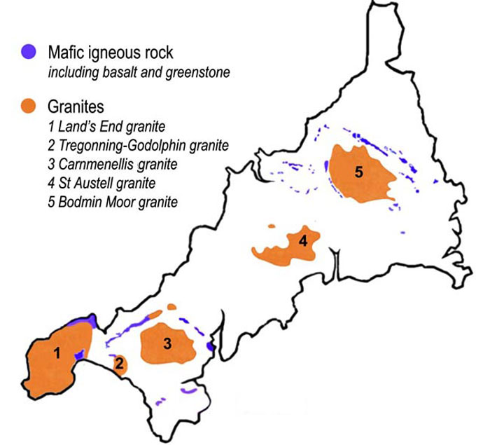
Bodmin Moor is one of five granite plutons in Cornwall that make up part of the Cornubian batholith. The intrusion dates from the Cisuralian epoch, the earliest part of the Permian period, and outcrops across about 190 km2 (73 sq mi). Around the pluton's margins where it intruded into Devonian slates, the country rock has been hornfelsed. Numerous peat deposits occur across the moor whilst large areas are characterised by blockfields of granite boulders; both deposits are of Quaternary age: the blockfields are a periglacial feature (i.e. Pleistocene Epoch) while the peat is Holocene age. (see also Geology of Cornwall).
Dramatic granite tors rise from the rolling moorland: the best known are Brown Willy, the highest point in Cornwall at 417 m (1,368 ft), and Rough Tor at 400 m (1,300 ft). To the south-east Kilmar Tor and Caradon Hill are the most prominent hills. Considerable areas of the moor are poorly drained and form marshes (in hot summers these can dry out). The rest of the moor is mostly rough pasture or covered with heather and other low vegetation.
The moor contains about 500 holdings with around 10,000 beef cows, 55,000 breeding ewes and 1,000 horses and ponies. Most of the moor is a Site of Special Scientific Interest (SSSI), Bodmin Moor, North, and has been designated an Area of Outstanding Natural Beauty (AONB), as part of Cornwall National Landscape. The moor has been identified by BirdLife International as an Important Bird Area (IBA) because it supports about 260 breeding pairs of European stonechats as well as a wintering population of 10,000 Eurasian golden plovers. The moor has also been recognised as a separate natural region and designated as national character area 153 by Natural England.
Institutional landowners within Bodmin Moor, North SSSI include the National Trust, the Ministry of Defence, the Forestry Commission and Highways England.
Bodmin Moor is the source of several of Cornwall's rivers: they are mentioned here anti-clockwise from the south.
The River Fowey rises at a height of 290 m (950 ft) and flows through Lostwithiel and into the Fowey estuary.
Hub AI
Bodmin Moor AI simulator
(@Bodmin Moor_simulator)
Bodmin Moor
Bodmin Moor (Cornish Standard Written Form: Goon Brenn) is a granite moorland in north-eastern Cornwall, England, United Kingdom. It is 208 square kilometres (80 sq mi) in size, and the granite dates from the Permian period of geological history. It includes Brown Willy, the highest point in Cornwall, and Rough Tor, a slightly lower peak. Many of Cornwall's rivers have their sources here. It has been inhabited since at least the Neolithic era, when early farmers started clearing trees and farming the land. They left their megalithic monuments, hut circles and cairns, and the Bronze Age culture that followed left further cairns, and more stone circles and stone rows. By medieval and modern times, nearly all the forest was gone and livestock rearing predominated.
The name Bodmin Moor is relatively recent. An early mention is in the Royal Cornwall Gazette of 28 November 1812. The upland area was formerly known as Fowey Moor after the River Fowey, which rises within it.
Bodmin Moor is one of five granite plutons in Cornwall that make up part of the Cornubian batholith. The intrusion dates from the Cisuralian epoch, the earliest part of the Permian period, and outcrops across about 190 km2 (73 sq mi). Around the pluton's margins where it intruded into Devonian slates, the country rock has been hornfelsed. Numerous peat deposits occur across the moor whilst large areas are characterised by blockfields of granite boulders; both deposits are of Quaternary age: the blockfields are a periglacial feature (i.e. Pleistocene Epoch) while the peat is Holocene age. (see also Geology of Cornwall).
Dramatic granite tors rise from the rolling moorland: the best known are Brown Willy, the highest point in Cornwall at 417 m (1,368 ft), and Rough Tor at 400 m (1,300 ft). To the south-east Kilmar Tor and Caradon Hill are the most prominent hills. Considerable areas of the moor are poorly drained and form marshes (in hot summers these can dry out). The rest of the moor is mostly rough pasture or covered with heather and other low vegetation.
The moor contains about 500 holdings with around 10,000 beef cows, 55,000 breeding ewes and 1,000 horses and ponies. Most of the moor is a Site of Special Scientific Interest (SSSI), Bodmin Moor, North, and has been designated an Area of Outstanding Natural Beauty (AONB), as part of Cornwall National Landscape. The moor has been identified by BirdLife International as an Important Bird Area (IBA) because it supports about 260 breeding pairs of European stonechats as well as a wintering population of 10,000 Eurasian golden plovers. The moor has also been recognised as a separate natural region and designated as national character area 153 by Natural England.
Institutional landowners within Bodmin Moor, North SSSI include the National Trust, the Ministry of Defence, the Forestry Commission and Highways England.
Bodmin Moor is the source of several of Cornwall's rivers: they are mentioned here anti-clockwise from the south.
The River Fowey rises at a height of 290 m (950 ft) and flows through Lostwithiel and into the Fowey estuary.