Hubbry Logo
BouthBouthMain
Open search
Bouth
Community hub
Bouth
logo
8 pages, 0 posts
0 subscribers
Be the first to start a discussion here.
Bouth
Bouth
from Wikipedia

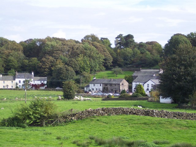
Bouth is a village in the Westmorland and Furness district of Cumbria, England. Historically, it was part of the county of Lancashire. It is within the Lake District National Park.

Key Information

The village's pub, the White Hart, was shown in the short-lived 1990 ITV sitcom Not with a Bang.

Notable people

[edit]


See also

[edit]
Road into Bouth

References

[edit]
[edit]
Revisions and contributorsEdit on WikipediaRead on Wikipedia
from Grokipedia
Bouth is a small village in the district of , , located within the and part of the Colton . Situated on high ground midway between the River Crake and Rusland Pool, at a historic junction of trails, it serves as a gateway between the towns of and Grange-over-Sands. The village, pronounced "Bowth," is notable for its medieval origins, 19th-century industrial heritage in production, and as the birthplace of musician of , born Christine Anne Perfect on July 12, 1943. Historically, Bouth's development began over 700 years ago as a simple sheepfold or meeting point for travelers, first documented in 1292 as "Bowth" in a land grant to Furness Abbey. It belonged to the of Colton and was part of until boundary changes in 1974 placed it in . The village prospered in the late 18th and early 19th centuries due to the 1776 Ireleth-to-Kendal turnpike road passing through it, enabling trade via the nearby port of , along with annual hiring fairs at Whitsuntide and October, and weekly produce markets. By 1849, Bouth supported six large farms, a malt kiln for local brewing, and four inns, including the 17th-century , which remains a key landmark today. Bouth's industrial peak came with the Black Beck Gunpowder Mills, operational from 1862 to 1928, which employed over 70 workers and produced explosives using local woodland resources like oak bark and charcoal. The mills were marred by tragedy, suffering 10 explosions that killed 33 men and injured many others, leading to their closure after a fatal 1928 incident. Other woodland-based industries, such as coppicing for bobbins, barrel hoops, staves, and shipbuilding materials, sustained the community alongside farming and peat digging. The opening of the A590 road in 1829 diverted traffic, causing economic decline and transforming Bouth into a quiet rural settlement. Today, as part of the broader Colton parish with a population of 649 (2021 census), Bouth attracts visitors for its scenic beauty, walking trails, and proximity to Lake District attractions, while preserving its square village layout possibly designed for livestock containment.

Geography

Location and boundaries

Bouth is situated in the district of , , at coordinates 54°15′42″N 3°01′56″W, corresponding to the OS grid reference SD3285. The village lies approximately 5 miles northeast of and 9 miles southwest of . It forms part of the Colton and is encompassed by the boundaries of the National Park. Administratively, Bouth is within the modern unitary authority of , which covers much of southern . Historically, the area belonged to the North Lonsdale hundred of , north of the sands, reflecting its position in the region before boundary changes transferred it to in 1974. The civil parish boundaries of Colton, which include Bouth, extend along natural features such as the Rusland Pool to the south, integrating the village into a broader rural landscape. The name Bouth derives from "búð," meaning a booth, , or temporary , indicative of early Norse settlement patterns in the region where such structures supported or trading activities. This aligns with the village's location in an area of historical Scandinavian influence, where place names often denote simple dwellings amid the fells.

Topography and climate

Bouth is situated in the Furness Fells region of the , characterized by gently rolling low hills and a shaped by glacial activity. The village itself lies at an average elevation of approximately 50 meters above , with surrounding terrain ranging from near to around 200 meters, encompassing undulating valleys and modest uplands. This includes scattered woodlands and streams, such as Black Beck, which flows through the area and contributes to the local . Nearby raised mire systems, part of broader formations, add to the diverse physical features, supporting unique wetland ecosystems. The predominant land use in Bouth is rural, dominated by farmland, coppice woodlands, and bogs, reflecting traditional agro- practices that have sustained the area's natural character. Farmland consists of valley-bottom hay meadows and grazed pastures, which maintain through management, while coppice woodlands provide habitats for species like red squirrels and deer. bogs and mires in the vicinity serve as significant carbon stores and refuges. As part of the , designated in 1951 for its outstanding natural beauty, the area is prioritized for conservation, with efforts focused on habitat restoration and sustainable to preserve its ecological integrity. Bouth experiences a temperate maritime , moderated by its proximity to the and the encircling fells, resulting in mild conditions year-round. Average annual rainfall measures between 1,200 and 1,600 mm, with higher in winter months due to Atlantic weather systems. Summer temperatures typically range from 15°C to 20°C, while winters average 2°C to 7°C, rarely dropping below freezing for extended periods. This supports lush but also contributes to frequent misty and overcast days, enhancing the region's atmospheric appeal.

History

Origins and medieval period

The village of Bouth originated from Norse settlements in the region during the 10th and 11th centuries, a period when Scandinavian influences were prominent in what is now . The name "Bouth" derives from the word búð, meaning a booth, , or temporary , reflecting the likely initial structures used by early settlers in this upland area. Bouth is first recorded in 1292, as "Bowth", in a by Alexander, son of Patrick, son of Gilbert, to Abbey. These Norse communities contributed to the dense pattern of Scandinavian place-names across the valleys of the and other Cumbrian rivers, indicating sustained Viking presence and integration into local landscapes. Although specific entries for Bouth or nearby Colton are absent from the of 1086, the broader area was recorded as part of the Manor of Hougun, noted for its pastoral and woodland resources under Anglo-Norman oversight. Limited records from this era suggest small-scale farming communities reliant on arable and livestock rearing amid forested terrain. During the medieval period, Bouth formed part of Colton parish, first documented as Coleton in 1202, within the ecclesiastical and manorial framework of the Fells. The area came under the influence of Abbey, a powerful Cistercian house founded in 1127, which managed local lands as granges for agricultural production and resource extraction. Monks utilized the woodlands for timber and charcoal, alongside pastoral farming, supporting the abbey's estates; by the , Colton holdings yielded rents of around £7 8s. 3d. annually from such activities. A key development occurred in 1337, when King Edward III granted Abbey free warren rights in their lands in , including areas such as Bouthe and Colton. These ties persisted until the abbey's dissolution in 1537, leaving records of modest, agrarian communities centered on subsistence farming and monastic oversight.

Industrial era and modern developments

During the 18th and 19th centuries, Bouth's economy was sustained by its surrounding coppice woodlands, which provided materials for regional industries including production from , barrel hoops and staves from , and contributions to in nearby Furness ports. Local woods in the Bouth area were actively managed for , supporting these woodland-based trades that employed residents in harvesting and processing timber for export via . The demand for , essential for manufacture, further integrated these woodlands into Bouth's industrial fabric, with coppice being a key resource. A significant boost came in 1860 with the establishment of the Black Beck Gunpowder Mills by the Dixon family, which operated until 1928 and at its peak employed over 70 locals, many involved in production from nearby coppice woods. The mills, powered by the Black Beck stream, produced for and quarrying, but suffered from frequent explosions—10 in total, claiming 33 lives—leading to their closure after a fatal 1928 incident that destroyed key equipment. This era marked Bouth's industrial peak, with the mills funding community facilities like a reading room (now the village hall) built in 1911 for workers. By 1910, Bouth's commercial landscape reflected a mix of traditional trades and services, including a , post office, cooperative store, butcher, grocer, coal merchant, timber merchant, and swiller producing wooden baskets from coppice materials. Following the mills' closure, woodland industries such as swill-making and production persisted but gradually declined post-World War II due to agricultural mechanization and reduced demand for handcrafted wooden goods. shifted toward farming and external opportunities in shipyards and factories, transforming Bouth from an industrial hub into a quieter increasingly oriented toward . In modern times, Bouth underwent administrative changes with the 1974 local government reform, transitioning from the historic county of to the new county of , aligning it more closely with the region. The village's population has since stabilized at a modest level, supported by local farming, at establishments like the Inn, and tourism via sites such as Black Beck Caravan Park. Preservation efforts intensified with Bouth's inclusion in the , designated in 1951, focusing on conserving its woodlands, historic structures, and rural character through habitat restoration and sustainable land management initiatives.

Governance and demographics

Administrative structure

Bouth forms part of the of Colton in , , where the Colton Parish Council operates as the primary local authority, comprising 9 elected councillors divided across 3 wards to manage community affairs including planning permissions, maintenance of local amenities, and the preparation of plans. The council functions as the lowest tier of , collaborating with higher authorities on issues like upkeep and community events. Colton civil parish, encompassing Bouth, lies within the , which was created on 1 April 2023 through the merger of the former district, borough, and councils, assuming responsibilities for services such as housing, , and across the region. Prior to this, from 1974 to 2023, the area fell under the district council within the two-tier structure of . Historically, Bouth and Colton were administered as part of the county of until the Local Government Act 1972 reorganized boundaries effective 1 April 1974, transferring the area—known as Lancashire North of the Sands—to the newly formed of . The village uses as its post town, with addresses in the LA12 postcode district and telephone numbers under the 01229 dialling code. For national representation, Bouth is included in the Barrow and Furness parliamentary constituency, which elects a to the . Emergency services covering the area include for policing, Cumbria Fire and Rescue Service for fire protection and prevention, and for medical emergencies. The population of Colton , which encompasses the village of Bouth, has experienced a steady decline over recent decades, reflecting broader rural trends in . According to records, the parish had 765 residents in 2001, falling to 672 in 2011 and further to 653 in 2021. This represents an overall decrease of approximately 15% over the 20-year period, attributed primarily to an aging population and net out-migration from rural areas seeking and services elsewhere. Bouth, as a small village within the parish, is estimated to have 150-200 residents, comprising a modest subset of the total. Demographically, Colton parish remains predominantly White, with 98.8% of residents identifying as such in the 2021 , exceeding the Cumbria-wide figure of 94.9% reported in the 2021 . The median age in the surrounding district stands at 51 years, notably higher than the national average of 40 years, underscoring the parish's aging profile where 37% of residents are aged 65 and over (243 individuals as of the 2021 ). Household composition is characterized by mostly owner-occupied rural homes; as of the 2011 , 83.3% of the 288 households were under owner-occupied tenure, with 310 resident households recorded in 2021. There has been an increase in one-person households among those under 66, aligning with Cumbria's regional trend of 18.2% for such households. Key factors influencing these demographics include a pronounced aging population, low levels of immigration (with 95.2% of Cumbria residents born in the UK), and employment patterns centered on agriculture and tourism, which limit influxes of younger workers and families.

Economy and infrastructure

Local economy

Historically, Bouth's economy revolved around woodland products derived from coppiced woods, which supplied materials such as bobbins, barrel hoops, staves, and components for shipping and tools, sustaining local industries from the medieval period through the early 20th century. Additionally, gunpowder production operated in the village from 1862 until its closure in 1928, contributing to industrial activity in the region. Small-scale trades, including butchery with a local slaughterhouse, cooperage related to barrel-making, shoemaking, nail-making, and wood merchandising, supported village self-sufficiency in the early 20th century. In the present day, agriculture remains a cornerstone, with farming focused on sheep rearing and production, employing about 7.3% of the local workforce in Colton Parish as of the 2011 census. has emerged as a key sector, driven by small-scale accommodations such as lets, stays, and caravan sites like Black Beck in Bouth, emphasizing low-impact visitor experiences within the National Park. Limited retail services persist, primarily through the White Hart Inn pub, which serves as a hub, though the village has transitioned to residential use. There are no local shops in Bouth, with residents relying on facilities in nearby areas such as Backbarrow or for groceries and essentials. As of the 2011 census, 67.4% of the parish population was economically active and 26.3% self-employed, but many residents commute to nearby towns like or Grange-over-Sands for employment in sectors such as retail (12.8% local) and services (12.0%). The 2021 census shows the economically active population (aged 16 and over) had declined to 301 residents, with 129 working mainly from home. The local economy faces challenges from rural depopulation, evidenced by a 12% population decline in Colton Parish between 2001 and 2011. This decline continued, with the population falling to 653 by the 2021 , alongside limited like poor access. In response, there is a growing shift toward eco-tourism and reliance on conservation grants through initiatives like the Rusland Horizons project, which promotes sustainable woodland management and preserves the area's ecological and tranquil character to bolster economic resilience.

Transport and services

Bouth has no railway station of its own, with the nearest mainline service at , approximately 6 miles southwest of the village. The heritage Lakeside and Haverthwaite Steam Railway, a 3.2-mile preserved line popular with tourists, operates from Haverthwaite station about 1.5 miles southeast, connecting to Lakeside on , roughly 3 miles from Bouth. options are limited due to the village's rural location. The X60 bus, operated by Blueworks Private Hire, provides a direct service from the stop opposite The pub in Bouth to and Newby Bridge, departing twice weekly on Thursdays with a journey time of around 50 minutes to . Connections to are available via the nearby X6 route, which can be boarded at stops in Backbarrow or Haverthwaite (both within 2 miles), offering hourly services on weekdays along the A590 corridor. The A590 trunk road runs parallel to the village approximately 2 miles south, providing efficient road access to regional destinations like and . Within Bouth, a network of narrow country lanes supports pedestrian and cycling use, integrating with the National Park's extensive trail system for recreational access to surrounding fells and woodlands. Local services cater to daily needs on a small scale, reflecting Bouth's status as a rural hamlet. Postal services are handled through a sub-post office with restricted availability, supplemented by nearby facilities in Backbarrow. Emergency services, including policing, firefighting, and medical response, are coordinated at the county level by Cumbria Constabulary, Cumbria Fire and Rescue Service, and North West Ambulance Service, with the closest response units based in Ulverston or Barrow-in-Furness. Utilities such as water and electricity are provided through standard regional networks by and , ensuring reliable supply to households and the community hall. The latter, recently refurbished and managed by a local committee, serves as a venue for events, meetings, and social gatherings. Broadband access is moderate, typical of rural , with ongoing fiber optic rollout via the Connecting Cumbria programme improving connectivity for homes and . Infrastructure enhancements in recent years have focused on sustainable access, including upgrades to footpaths linking Bouth to trails, such as those around Grizedale Forest and the River Leven, to better accommodate walkers and cyclists while protecting the landscape. These improvements support the area's by facilitating low-impact exploration of natural sites.

Culture and landmarks

Notable sites and buildings

One of the most prominent landmarks in Bouth is the Inn, a 17th-century exemplifying traditional Lakeland architecture with its low-slung stone structure, slate roof, and interior adorned with historic farming implements. This establishment serves as a longstanding social hub for the community, offering dining and lodging amid the Rusland Valley's scenic surroundings. It gained cultural recognition by featuring in the short-lived 1990 ITV sitcom Not with a Bang, which depicted end-of-the-world scenarios set in the village. The remnants of the Black Beck Gunpowder Mills, operational from 1860 to 1928, stand as key relics of Bouth's industrial heritage, including preserved structures like the saltpetre house, watch house, and cooperage, alongside earthworks and tramway remnants now integrated into local paths. These sites highlight the area's past role in Cumbria's production for and quarrying. Bouth falls within the parish of Colton, where Holy Trinity Church serves as the nearby place of worship, dating to 1531–1539 on the site of an earlier medieval chapel and featuring elements like a reused font from that period. Adjacent to Bouth, the Rusland Moss National Nature Reserve spans 22 hectares as one of the few remaining raised mires in northern England, characterized by peat-forming Sphagnum mosses, boardwalks for accessible viewing, and habitats supporting rare species such as the large heath butterfly and wood warbler. These sites contribute to Bouth's through extensive walking trails along ancient routes and attractions like Black Beck Farm's holiday caravans, underscoring a commitment to conservation within the .

Notable people

(1943–2022), born Christine Perfect in the village of Bouth, was an English and best known as a longtime member of the rock band . She spent her early childhood in nearby before the family relocated to Birmingham when she was around four years old. McVie joined in 1970, contributing as a co-lead vocalist, , and primary songwriter on hits such as "," "Everywhere," and "," which helped propel the band to global stardom. Her contributions earned her a Grammy Award for Album of the Year in 1978 for Rumours, among other accolades, and she was inducted into the Rock and Roll Hall of Fame with the band in 1998. In 2024, a biography titled was published, exploring her life and career, including her childhood in the . Other notable associations with Bouth include the Benson family, who were prominent landowners at Blackbeck estate during the 17th and 18th centuries. Arthur Benson (d. 1643), for instance, resided in Bouth and represented a lineage tied to local landownership. While Bouth has produced no other major international figures, histories highlight contributors such as early 20th-century tradespeople—including butchers, tailors, shoemakers, and merchants—who sustained the village's self-sufficient through local businesses. McVie's rural upbringing, with its natural landscapes and early exposure to music through her violinist father, subtly influenced her songwriting, evoking themes of emotional steadiness and in her work. The village takes pride in her as a cultural export, with local tributes emphasizing her roots following her death.

References

Add your contribution
Related Hubs
User Avatar
No comments yet.