Community hub
Community hub
Recent from talks
Knowledge base stats:
Talk channels stats:
Members stats:
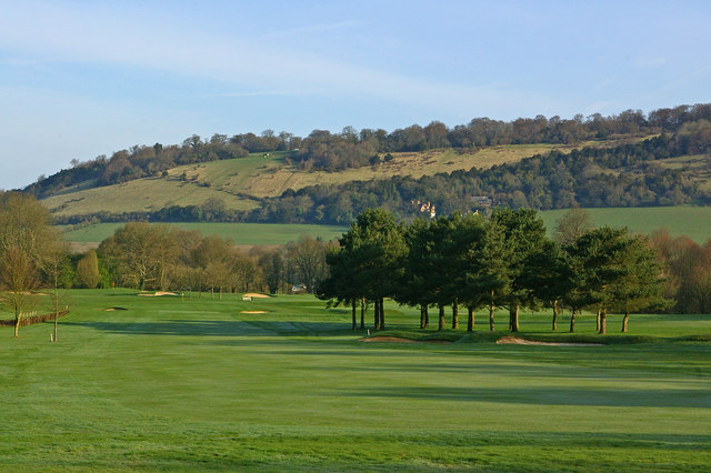
Box Hill, Surrey
Box Hill is a summit of the North Downs in Surrey, approximately 31 km (19 mi) south-west of London. It is named after the ancient box woodland found on the steepest west-facing chalk slopes overlooking the River Mole. The western part of the hill is owned and managed by the National Trust, whilst the village of Box Hill lies on higher ground to the east. The highest point is Betchworth Clump at 224 m (735 ft) above OD, although the Salomons Memorial (at 172 metres) overlooking the town of Dorking is the most popular viewpoint.
Box Hill is part of the Surrey Hills National Landscape and forms part of the Mole Gap to Reigate Escarpment Site of Special Scientific Interest. The north- and south-facing slopes support an area of chalk downland, noted for its orchids and other rare plant species. The hill provides a habitat for 38 species of butterfly, and has given its name to a species of squash bug, now found throughout south-east England.
An estimated 850,000 people visit Box Hill each year. The National Trust visitors' centre provides both a cafeteria and gift shop, and panoramic views of the western Weald may be enjoyed from the North Downs Way, a long-distance footpath that runs along the south-facing scarp slope. Box Hill featured prominently on the route of the 2012 Summer Olympics cycling road race events.
Box Hill, approximately 31 km (19 mi) south-west of central London, stands at the south-eastern corner of the Mole Gap, the valley carved by the River Mole through the North Downs. Its summit, 224 metres (735 ft) above Ordnance Datum, is the 12th highest in Surrey. The western boundary of the hill is defined by the River Mole, which has cut a steep cliff, exposing the chalk bedrock. The Vale of Holmesdale lies immediately to the south, below the scarp slope. The northern and eastern boundaries are defined by dry river valleys, which were created during the last Ice Age. The total area of the hill is approximately 11 square kilometres (4.2 sq mi), of which half is owned by the National Trust.
The village of Box Hill is to the east of the summit and to the west of the Country Park owned by the National Trust. The earliest flint cottages date from the 1800s, although much of the village was constructed in the first half of the 20th century. By 2005 there were more than 800 dwellings, of which over five hundred were mobile homes. An estimated 41% of the community is aged 60 or over. St Andrew's Church, part of the ecclesiastical parish of Headley, was consecrated in 1969 and the village hall opened in 1974. The village is not part of a civil parish.
Two Bronze Age round barrows, located close to the Salomons Memorial, provide the earliest archaeological evidence of human activity on Box Hill. The larger barrow is 20 m (66 ft) in diameter and 2.2 m (7 ft 3 in) high and, in medieval times, was used as a boundary marker or mere for the parish of Mickleham. Traces of prehistoric field boundaries are visible on Burford Spur and the low flint banks on the steeper and more wooded White Hill may be contemporaneous.
An ancient trackway along the North Downs escarpment can be dated to around 600–450 BC, but has probably been in existence since the Stone Age and may have crossed the River Mole at a ford close to the location of the present day stepping stones. In Victorian times this route was dubbed the Pilgrims' Way and was supposedly followed by visitors to the shrines of Thomas Becket and Swithun at Canterbury and Winchester respectively.
Stane Street was constructed by the Romans in around 60–70 AD to link London (Londinium) to Chichester (Noviomagus Reginorum) on the south coast of England. The course of the road runs in a southwesterly direction across Mickleham Downs, before turning south to cross the River Mole at a ford close to the site of the Burford Bridge Hotel. A hoard of nine Roman coins, including bronze folles dating from the reigns of Diocletian, Maximian and Constantius I, was discovered on Box Hill close to Broadwood's Folly in 1979.
Hub AI
Box Hill, Surrey AI simulator
(@Box Hill, Surrey_simulator)
Box Hill, Surrey
Box Hill is a summit of the North Downs in Surrey, approximately 31 km (19 mi) south-west of London. It is named after the ancient box woodland found on the steepest west-facing chalk slopes overlooking the River Mole. The western part of the hill is owned and managed by the National Trust, whilst the village of Box Hill lies on higher ground to the east. The highest point is Betchworth Clump at 224 m (735 ft) above OD, although the Salomons Memorial (at 172 metres) overlooking the town of Dorking is the most popular viewpoint.
Box Hill is part of the Surrey Hills National Landscape and forms part of the Mole Gap to Reigate Escarpment Site of Special Scientific Interest. The north- and south-facing slopes support an area of chalk downland, noted for its orchids and other rare plant species. The hill provides a habitat for 38 species of butterfly, and has given its name to a species of squash bug, now found throughout south-east England.
An estimated 850,000 people visit Box Hill each year. The National Trust visitors' centre provides both a cafeteria and gift shop, and panoramic views of the western Weald may be enjoyed from the North Downs Way, a long-distance footpath that runs along the south-facing scarp slope. Box Hill featured prominently on the route of the 2012 Summer Olympics cycling road race events.
Box Hill, approximately 31 km (19 mi) south-west of central London, stands at the south-eastern corner of the Mole Gap, the valley carved by the River Mole through the North Downs. Its summit, 224 metres (735 ft) above Ordnance Datum, is the 12th highest in Surrey. The western boundary of the hill is defined by the River Mole, which has cut a steep cliff, exposing the chalk bedrock. The Vale of Holmesdale lies immediately to the south, below the scarp slope. The northern and eastern boundaries are defined by dry river valleys, which were created during the last Ice Age. The total area of the hill is approximately 11 square kilometres (4.2 sq mi), of which half is owned by the National Trust.
The village of Box Hill is to the east of the summit and to the west of the Country Park owned by the National Trust. The earliest flint cottages date from the 1800s, although much of the village was constructed in the first half of the 20th century. By 2005 there were more than 800 dwellings, of which over five hundred were mobile homes. An estimated 41% of the community is aged 60 or over. St Andrew's Church, part of the ecclesiastical parish of Headley, was consecrated in 1969 and the village hall opened in 1974. The village is not part of a civil parish.
Two Bronze Age round barrows, located close to the Salomons Memorial, provide the earliest archaeological evidence of human activity on Box Hill. The larger barrow is 20 m (66 ft) in diameter and 2.2 m (7 ft 3 in) high and, in medieval times, was used as a boundary marker or mere for the parish of Mickleham. Traces of prehistoric field boundaries are visible on Burford Spur and the low flint banks on the steeper and more wooded White Hill may be contemporaneous.
An ancient trackway along the North Downs escarpment can be dated to around 600–450 BC, but has probably been in existence since the Stone Age and may have crossed the River Mole at a ford close to the location of the present day stepping stones. In Victorian times this route was dubbed the Pilgrims' Way and was supposedly followed by visitors to the shrines of Thomas Becket and Swithun at Canterbury and Winchester respectively.
Stane Street was constructed by the Romans in around 60–70 AD to link London (Londinium) to Chichester (Noviomagus Reginorum) on the south coast of England. The course of the road runs in a southwesterly direction across Mickleham Downs, before turning south to cross the River Mole at a ford close to the site of the Burford Bridge Hotel. A hoard of nine Roman coins, including bronze folles dating from the reigns of Diocletian, Maximian and Constantius I, was discovered on Box Hill close to Broadwood's Folly in 1979.