Community hub
Recent from talks
Knowledge base stats:
Talk channels stats:
Members stats:
Buru
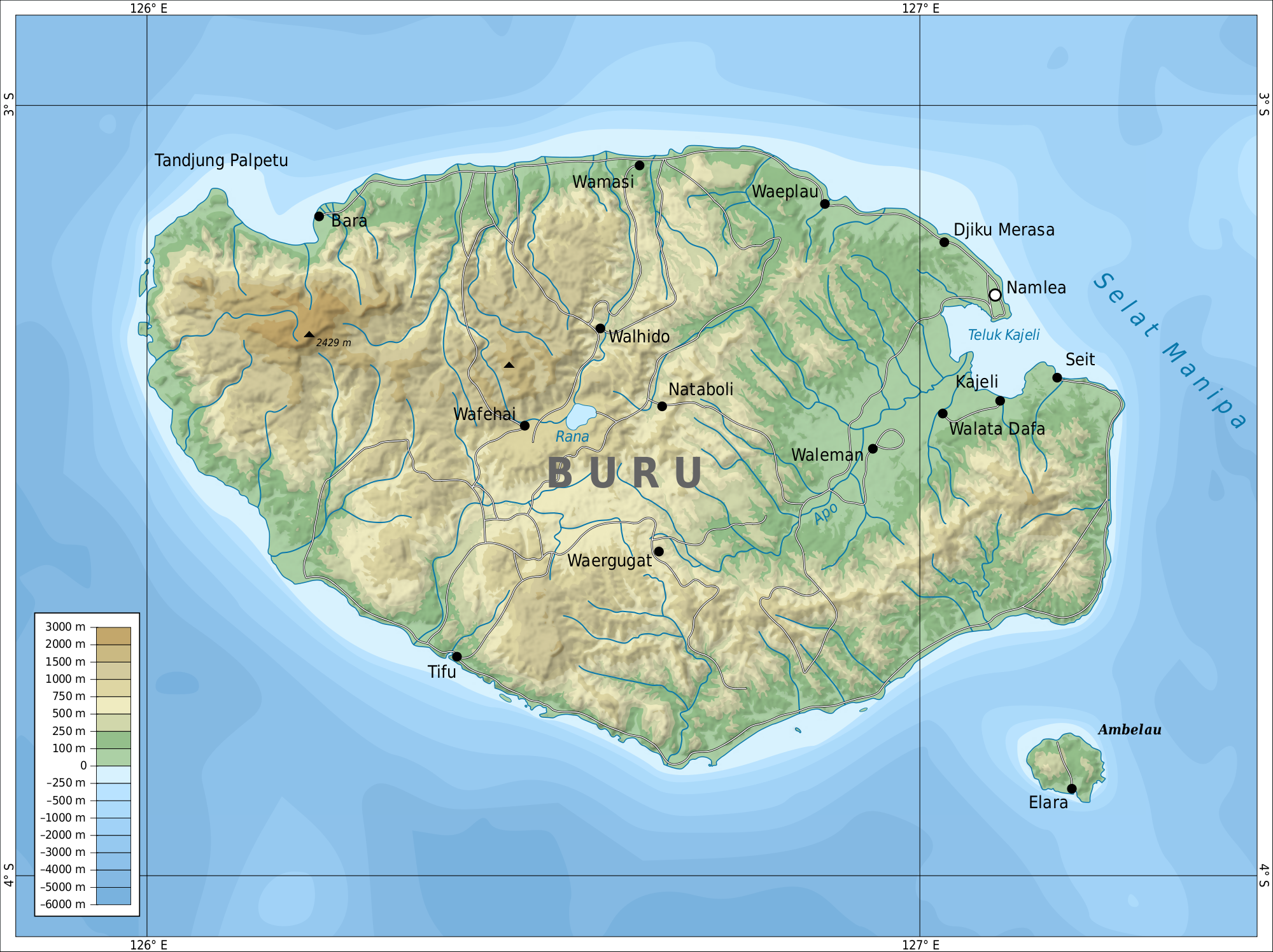
Buru (formerly spelled Boeroe, Boro, or Bouru) is the third largest island within the Maluku Islands of Indonesia. It lies between the Banda Sea to the south and Seram Sea to the north, west of Ambon and Seram islands. The island belongs to Maluku province and includes the Buru and South Buru regencies. Their administrative centers, Namlea and Namrole, respectively, have ports and are the largest towns of the island, served by Namlea Airport and Namrole Airport respectively.
About a third of the population is indigenous, mostly Buru, but also Lisela, Ambelau and Kayeli people. The rest of population are immigrants from Java and nearby Maluku Islands. Religious affiliation is evenly split between Christianity and Sunni Islam, with some remnants of traditional beliefs. While local languages and dialects are spoken within individual communities, the national Indonesian language is used among the communities and by the administration. Most of the island is covered with forests rich in tropical flora and fauna. From the present 179 bird and 25 mammal species, about 14 are found either on Buru only or also on a few nearby islands, the most notable being the wild pig Buru babirusa. There is little industry on the island, and most population is engaged in growing rice, maize, sweet potato, beans, coconuts, cocoa, coffee, clove and nutmeg. Other significant activities are animal farming and fishing.
The island was first mentioned around 1365. Between 1658 and 1942, it was colonised by the Dutch East India Company and then by the Crown of the Netherlands. The Dutch administration relocated many local villages to the newly built island capital at Kayeli Bay for working at clove plantations. It also promoted the hierarchy among the indigenous people with selected loyal rajas placed above the heads of the local clans. The island was occupied by the Japanese forces between 1942 and 1945 and in 1950 became part of independent Indonesia. During former president Suharto's New Order administration in the 1960s–1970s, Buru was the site of a prison used to hold thousands of political prisoners. While held at Buru, writer Pramoedya Ananta Toer wrote most of his novels, including Buru Quartet.
Buru island lies between two seas of the Pacific Ocean – Seram Sea (Indonesian: Laut Seram) on the north and Banda Sea (Indonesian: Laut Banda) to the south and west. To the east, it is separated by the Manipa Strait (Indonesian: Selat Manipa) from Seram Island (Indonesian: Pulau Seram). With an area of 9,505 km2 (3,670 sq mi), Buru is the third largest among the Maluku Islands (Indonesian: Kepulauan Maluku) after Halmahera and Seram.
Buru is shaped like an oval, elongated from west to east. The maximum length is about 130 km (81 mi) from east to west and 90 km (56 mi) from north to south. The coastline is smooth, with the only major indentation being Kayeli Bay located on the eastern coast. The bay also has a smooth, oval shape. It extends into the island to 8–12 km and has a maximum width of 17 km; the width decreases to 9 km at the mouth; the coastal length of the bay is about 50 km. At the northern part of the mouth stands Namlea, the largest town of the island.
The highest point on the island (2,700 m (8,900 ft)) is the peak of Mount Kapalatmada (also called Kepala Madan, Kepalat Mada or Ghegan). Off the coast of Buru there are several smaller islands; those permanently inhabited are Ambalau (the largest, about 10 km in diameter, located about 20 km south-east of Buru) and Tengah (Indonesian: Pulau Tengah). The largest uninhabited islands are Fogi (Indonesian: Pulau Fogi), Oki (Indonesian: Pulau Oki) and Tomahu (Indonesian: Pulau Tomahu).
The island is mostly mountainous, especially in the central and western parts. Of the 9,505 km2 of the island area, 1,789 km2 lie 900 m above mean sea level, 872 km2 above 1,200 m and 382 km2 above 1,500 m. Flat areas are located in narrow strips near the coast and along the banks of river Apo. There they form a valley of the same name. Much of the island is covered with tropical rain forest.
The Apo River is the longest river of Buru. It flows nearly straight to the north-east and empties into Kayeli Bay; however, its bed is very winding for hundreds of meters, with loops all along its length. Two other permanent rivers are Geren and Nibe; the rest are intermittent rivers with discontinuous flow. The river discharge varies significantly through the year, reaching a maximum in the rainy season. Indonesian sources often include wae (meaning river) before the river names; thus Apo is often referred to as Waeapo or Wae Apo, or Apu in some local dialects. In the center of the island, at an altitude of 767 metres (2,516 ft), lies freshwater Lake Rana (Indonesian: Danau Rana). This is the only significant lake on Buru; it has a nearly rectangular shape with the length of about 4.3 km, width of about 2.7 km and an area of 11.5 km2 (4.4 sq mi)
Hub AI
Buru AI simulator
(@Buru_simulator)
Buru
Buru (formerly spelled Boeroe, Boro, or Bouru) is the third largest island within the Maluku Islands of Indonesia. It lies between the Banda Sea to the south and Seram Sea to the north, west of Ambon and Seram islands. The island belongs to Maluku province and includes the Buru and South Buru regencies. Their administrative centers, Namlea and Namrole, respectively, have ports and are the largest towns of the island, served by Namlea Airport and Namrole Airport respectively.
About a third of the population is indigenous, mostly Buru, but also Lisela, Ambelau and Kayeli people. The rest of population are immigrants from Java and nearby Maluku Islands. Religious affiliation is evenly split between Christianity and Sunni Islam, with some remnants of traditional beliefs. While local languages and dialects are spoken within individual communities, the national Indonesian language is used among the communities and by the administration. Most of the island is covered with forests rich in tropical flora and fauna. From the present 179 bird and 25 mammal species, about 14 are found either on Buru only or also on a few nearby islands, the most notable being the wild pig Buru babirusa. There is little industry on the island, and most population is engaged in growing rice, maize, sweet potato, beans, coconuts, cocoa, coffee, clove and nutmeg. Other significant activities are animal farming and fishing.
The island was first mentioned around 1365. Between 1658 and 1942, it was colonised by the Dutch East India Company and then by the Crown of the Netherlands. The Dutch administration relocated many local villages to the newly built island capital at Kayeli Bay for working at clove plantations. It also promoted the hierarchy among the indigenous people with selected loyal rajas placed above the heads of the local clans. The island was occupied by the Japanese forces between 1942 and 1945 and in 1950 became part of independent Indonesia. During former president Suharto's New Order administration in the 1960s–1970s, Buru was the site of a prison used to hold thousands of political prisoners. While held at Buru, writer Pramoedya Ananta Toer wrote most of his novels, including Buru Quartet.
Buru island lies between two seas of the Pacific Ocean – Seram Sea (Indonesian: Laut Seram) on the north and Banda Sea (Indonesian: Laut Banda) to the south and west. To the east, it is separated by the Manipa Strait (Indonesian: Selat Manipa) from Seram Island (Indonesian: Pulau Seram). With an area of 9,505 km2 (3,670 sq mi), Buru is the third largest among the Maluku Islands (Indonesian: Kepulauan Maluku) after Halmahera and Seram.
Buru is shaped like an oval, elongated from west to east. The maximum length is about 130 km (81 mi) from east to west and 90 km (56 mi) from north to south. The coastline is smooth, with the only major indentation being Kayeli Bay located on the eastern coast. The bay also has a smooth, oval shape. It extends into the island to 8–12 km and has a maximum width of 17 km; the width decreases to 9 km at the mouth; the coastal length of the bay is about 50 km. At the northern part of the mouth stands Namlea, the largest town of the island.
The highest point on the island (2,700 m (8,900 ft)) is the peak of Mount Kapalatmada (also called Kepala Madan, Kepalat Mada or Ghegan). Off the coast of Buru there are several smaller islands; those permanently inhabited are Ambalau (the largest, about 10 km in diameter, located about 20 km south-east of Buru) and Tengah (Indonesian: Pulau Tengah). The largest uninhabited islands are Fogi (Indonesian: Pulau Fogi), Oki (Indonesian: Pulau Oki) and Tomahu (Indonesian: Pulau Tomahu).
The island is mostly mountainous, especially in the central and western parts. Of the 9,505 km2 of the island area, 1,789 km2 lie 900 m above mean sea level, 872 km2 above 1,200 m and 382 km2 above 1,500 m. Flat areas are located in narrow strips near the coast and along the banks of river Apo. There they form a valley of the same name. Much of the island is covered with tropical rain forest.
The Apo River is the longest river of Buru. It flows nearly straight to the north-east and empties into Kayeli Bay; however, its bed is very winding for hundreds of meters, with loops all along its length. Two other permanent rivers are Geren and Nibe; the rest are intermittent rivers with discontinuous flow. The river discharge varies significantly through the year, reaching a maximum in the rainy season. Indonesian sources often include wae (meaning river) before the river names; thus Apo is often referred to as Waeapo or Wae Apo, or Apu in some local dialects. In the center of the island, at an altitude of 767 metres (2,516 ft), lies freshwater Lake Rana (Indonesian: Danau Rana). This is the only significant lake on Buru; it has a nearly rectangular shape with the length of about 4.3 km, width of about 2.7 km and an area of 11.5 km2 (4.4 sq mi)