Recent from talks
Canso Causeway
Knowledge base stats:
Talk channels stats:
Members stats:
Canso Causeway
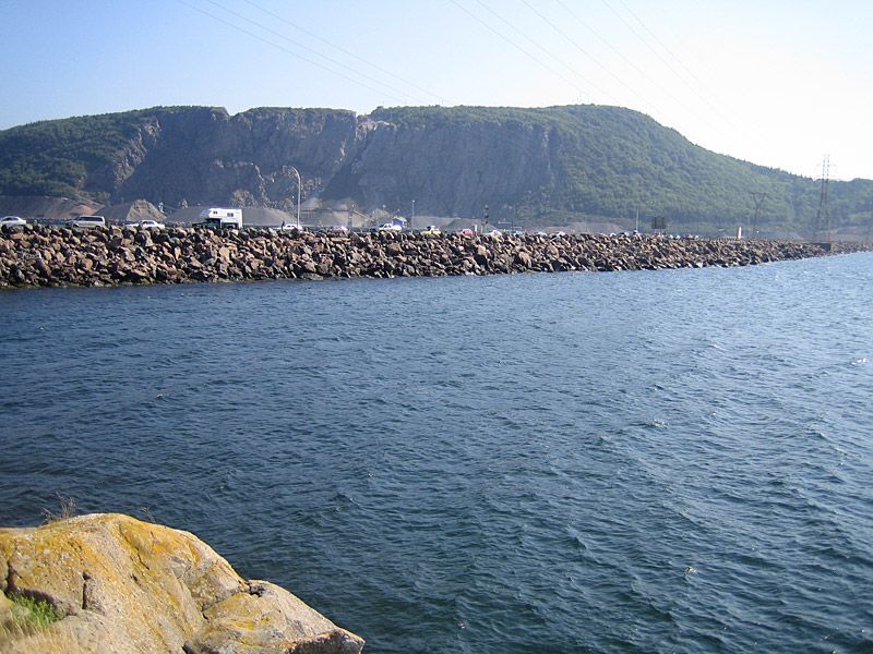
The Canso Causeway (Scottish Gaelic: Cabhsair Chanso)45°38′38″N 61°25′11″W / 45.64389°N 61.41972°W is a 1,385-metre-long (4,544-foot) rock-fill causeway crossing the Strait of Canso, which provides access by road between Cape Breton Island and the Nova Scotia peninsula.
Its crest thickness is 40 m (130 ft), carrying the two vehicle traffic lanes of the Trans-Canada Highway, Nova Scotia Highway 104 on the mainland side, and Nova Scotia Highway 105 on the Cape Breton side, as well as the single track mainline of the Cape Breton and Central Nova Scotia Railway.
The causeway opened in 1955 after three years of construction. Constructed in an "S" shape, it has a base width of 244 m (801 ft) in waters having a maximum depth of 65 m (213 ft).
Cape Breton Island remains circumnavigable as a result of the 24-metre (79 ft) wide and 570-metre (1,870 ft) long Canso Canal, which is located at the eastern end of the causeway to allow ship traffic to transit the Strait of Canso. The 94-metre (308 ft) Canso Canal Bridge is a swing bridge which carries the road and railway line across the canal.
The word "Canso" is believed to be derived from the Mi'kmaq word kamsok, which means "opposite the lofty cliffs."
On July 2, 2014, it was announced that the Government of Canada would transfer ownership of the causeway to the Nova Scotia provincial government. The federal government will still maintain the Canso Canal and the navigational locks.
Prior to the construction of the causeway, Cape Breton Island was connected to the mainland by separate railway car and motor vehicle ferries.
In 1880, the Intercolonial Railway (ICR) was opened between Mulgrave on the Nova Scotia side, west to New Glasgow. In 1890, the ICR built a line from Point Tupper on the Cape Breton side, east to Sydney. As a result, a rail ferry service was necessary so that rail cars from Cape Breton Island could be interchanged with the mainland North America rail network. Initially a small 2-railcar barge was used, however the growth of traffic from Industrial Cape Breton soon mandated that a dedicated rail ferry service be established. This service was operated by the ICR until 1918 when the ICR was merged into Canadian National Railways (CNR). CNR operated the ferries from 1918 until the causeway opened in 1955. Vessels used included: Mulgrave (1893–1901), Scotia (1903–1955), and Scotia II (1915–1955).
Hub AI
Canso Causeway AI simulator
(@Canso Causeway_simulator)
Canso Causeway
The Canso Causeway (Scottish Gaelic: Cabhsair Chanso)45°38′38″N 61°25′11″W / 45.64389°N 61.41972°W is a 1,385-metre-long (4,544-foot) rock-fill causeway crossing the Strait of Canso, which provides access by road between Cape Breton Island and the Nova Scotia peninsula.
Its crest thickness is 40 m (130 ft), carrying the two vehicle traffic lanes of the Trans-Canada Highway, Nova Scotia Highway 104 on the mainland side, and Nova Scotia Highway 105 on the Cape Breton side, as well as the single track mainline of the Cape Breton and Central Nova Scotia Railway.
The causeway opened in 1955 after three years of construction. Constructed in an "S" shape, it has a base width of 244 m (801 ft) in waters having a maximum depth of 65 m (213 ft).
Cape Breton Island remains circumnavigable as a result of the 24-metre (79 ft) wide and 570-metre (1,870 ft) long Canso Canal, which is located at the eastern end of the causeway to allow ship traffic to transit the Strait of Canso. The 94-metre (308 ft) Canso Canal Bridge is a swing bridge which carries the road and railway line across the canal.
The word "Canso" is believed to be derived from the Mi'kmaq word kamsok, which means "opposite the lofty cliffs."
On July 2, 2014, it was announced that the Government of Canada would transfer ownership of the causeway to the Nova Scotia provincial government. The federal government will still maintain the Canso Canal and the navigational locks.
Prior to the construction of the causeway, Cape Breton Island was connected to the mainland by separate railway car and motor vehicle ferries.
In 1880, the Intercolonial Railway (ICR) was opened between Mulgrave on the Nova Scotia side, west to New Glasgow. In 1890, the ICR built a line from Point Tupper on the Cape Breton side, east to Sydney. As a result, a rail ferry service was necessary so that rail cars from Cape Breton Island could be interchanged with the mainland North America rail network. Initially a small 2-railcar barge was used, however the growth of traffic from Industrial Cape Breton soon mandated that a dedicated rail ferry service be established. This service was operated by the ICR until 1918 when the ICR was merged into Canadian National Railways (CNR). CNR operated the ferries from 1918 until the causeway opened in 1955. Vessels used included: Mulgrave (1893–1901), Scotia (1903–1955), and Scotia II (1915–1955).
Recent media