Recent from talks
Nothing was collected or created yet.
Carnforth
View on Wikipedia
Carnforth is a market town and civil parish in the City of Lancaster in Lancashire, England, situated at the north-east end of Morecambe Bay. The parish of Carnforth had a population of 5,560 in the 2011 census,[1] an increase from the 5,350 recorded in the 2001 census.[2] The town is situated around 7 miles north of Lancaster, 17 miles south of Kendal, 40 miles east (bisected by Morecambe Bay) of Barrow-in-Furness and 28 miles north-west of Settle. The town is also close to the Cumbria/Lancashire border.
Key Information
Carnforth grew in the 19th century through the presence of the railway and ironworks. Due to the closeness of the coast and the hills, Carnforth is a popular base for walkers and cyclists exploring the area. The River Keer, the West Coast Main Line (WCML), the A6 and the Lancaster Canal pass through the town. The M6 motorway passes just to the east, linked to Carnforth by the A6070 (formerly the A601(M)) which was originally part of the Lancaster bypass before the M6 was extended north.
History
[edit]
The name Carnforth is thought to derive from its old function as a ford of the River Keer on which it is situated. Over time, the descriptive name Keer-ford may have morphed into the modern Carnforth. An alternative explanation is that the name derives from 'Chreneforde' and is Anglo-Saxon in origin, as cited in the Victoria County History of Lancashire.[3] Another explanation is that it derives from the Old English cranford meaning 'crane ford'.[4]
Much of the history of Carnforth revolves around the railway and ironworks. Vast deposits of limestone located locally made Carnforth an ideal place for an ironworks, as limestone is a key component of the smelting process. In 1846, the Carnforth Ironworks Company established a works near to the railway station. In the same year, a recession occurred in the Earl of Dudley ironworks in Worcestershire, which meant there was a surplus of workers. A number of workers moved to the ironworks and lived in the nearby company village of Dudley (now called Millhead). In 1864, the Carnforth Haematite Company took over the works and production was vastly increased due to iron ore that was brought in by rail from the Furness Peninsula. By 1872, steel production became the main focus for the works using the new Bessemer process; this process had failed by 1879.[citation needed]
Iron production continued at the works until 1929, when it eventually closed down. The site was taken over by the War Department, as an ordnance depot and remained as such until the 1960s. From then to the present, the site is now an industrial estate housing several businesses.[5]

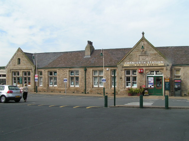
In the 19th century, Carnforth grew from a small village into a railway town when it became the junction of three major railways. Carnforth Motive Power Depot was located to the west of the West Coast Main Line and, until mid-1968, was one of the last to retain an allocation of steam locomotives. The buildings are now occupied by West Coast Railways[6] who still maintain and overhaul steam locos in their premises. The concrete locomotive coaling tower is a rare survivor.
With the closure of Carnforth MPD in 1968, the station's facilities were reduced. The main line platforms were closed in May 1970 and subsequently removed when the line was electrified two years later, although services still run on the Furness line and the Bentham Line.

From the 1920s to the 1980s, Morphy's Mill, in Oxford Street, was a major employer of women in Carnforth. Contrary to its name, it was not a mill but a factory making blouses and other garments.[7][8]
Brief Encounter
[edit]In 1945, Carnforth railway station was used as a location for the David Lean film Brief Encounter, starring Celia Johnson and Trevor Howard. Fans of this film were one of the major factors in the recent refurbishment of the railway station, including construction of a refreshment room to match the studio set used in the film. This reopened in 2021 as the Brief Encounter Refreshment Room Bistro and Bar.[9] There are also exhibitions and a heritage centre, which is now run by the Carnforth Station Trust.[10] The 2018 novel Past Encounters by local writer Deborah Swift is set, in part, in Carnforth during the filming of Brief Encounter.[11]
- Gallery of film locations
-
Carnforth railway station refreshment room - scene for much of the film
-
Carnforth railway station clock and ramp from subway under platforms
Governance
[edit]An electoral ward in the same name exists. This ward is smaller than the parish with a total population of 4,439.[12]
Carnforth is in the parliamentary constituency of Morecambe and Lunesdale, represented since 2024 by Lizzi Collinge of the Labour Party.[13]
Geography
[edit]The River Keer runs through the north-north-west of the town with the mouth of the river flowing into Morecambe Bay. It forms the parish boundary between Carnforth and Warton. A bridge between Carnforth and Millhead is the lowest road crossing of the river, although there is a footbridge a little further downstream.[14]
Demography
[edit]The Office for National Statistics recognises an area described as Carnforth Built-up area,[15] defined algorithmically, which includes Carnforth and Warton. It is divided into two parts: Carnforth subdivision,[16] which includes the Millhead area within Warton parish, and Warton subdivision.[17] The ONS definition of a built-up area includes built-up land separated by 200m from another settlement.[18]
| Named area | Population | Area | Population density | Note |
|---|---|---|---|---|
| Carnforth civil parish[1] | 5,560 | 6.09 km2 (2.35 sq mi) | 910/km2 (2,400/sq mi) | |
| Carnforth ward[19] | 4,439 | 5.33 km2 (2.06 sq mi) | 830/km2 (2,100/sq mi) | Excludes Crag Bank area |
| Carnforth Built-up area[15] | 7,920 | 2.33 km2 (0.90 sq mi) | 3,400/km2 (8,800/sq mi) | Comprises Carnforth and Warton Built-up area subdivisions |
| Carnforth Built-up area subdivision[16] | 6,115 | 1.75 km2 (0.68 sq mi) | 3,480/km2 (9,000/sq mi) | Includes Millhead area |
| Warton Built-up area subdivision[17] | 1,805 | 0.575 km2 (0.222 sq mi) | 3,140/km2 (8,100/sq mi) | Excludes Millhead area |
Health service
[edit]There is a general practice surgery in the town, with eleven partners and four associate GPs. It has smaller surgeries in Arnside, Bolton-le-Sands, Halton, and Silverdale, to serve patients in outlying villages.[20] It is within the North Lancashire clinical commissioning group and patients are served by the University Hospitals of Morecambe Bay NHS Foundation Trust.
There is also an NHS clinic, adjacent to the GP practice, used for a variety of services.[21][22]
Transport
[edit]
Carnforth railway station is served by Northern Trains on three lines:[23]
- Bentham Line: Services operate between Leeds and Morecambe, via Skipton
- Furness line: Trains link Manchester Airport with Barrow-in-Furness, via Lancaster. Some trains continue to Carlisle, via Whitehaven
- Morecambe Branch Line: A single daily parliamentary train service travels to Morecambe, via the north curve at Hest Bank.
The West Coast Main Line passes through the station, but Avanti West Coast trains do not stop here; passengers must travel south to Lancaster or north to Oxenholme for destinations between London Euston and Glasgow Central.
Bus services in the town are provided by Stagecoach Cumbria and North Lancashire and Kirkby Lonsdale Coaches. Routes connect the town with Lancaster and Morecambe to the south, and to Milnthorpe, Kendal and Keswick in the north.[24] The 555 bus, which connects Lancaster with Keswick, is described as one of the longest and most scenic bus routes in England.[25]
Carnforth is on the A6 road 7 miles (11 km) north of Lancaster.[14] The M6 motorway passes to the east of the town; the A601(M) motorway and the B6254 road connect the town centre to junction 35.
The Lancaster Canal passes through the town; there is a marina for pleasure boats. Historically, the canal connected Lancaster to Kendal, but it is now closed beyond Tewitfield, north of Carnforth.
Both the Lancashire Coastal Way and the Bay Cycle Way skirt the western side of Carnforth, crossing the River Keer by the footbridge north-west of the town.
Media
[edit]Local TV coverage is provided by BBC North West and ITV Granada. Television signals are received from the Lancaster relay TV transmitter.[26]
Local radio stations are BBC Radio Lancashire, Heart North West, Smooth North West, Greatest Hits Radio Lancashire, and Beyond Radio, a community based station which broadcasts from its studios in Lancaster.[citation needed]
Local newspapers are Lancaster Guardian (formerly The Visitor),[27] The Westmorland Gazette,[28] and Lancashire Evening Post.[29]
Education
[edit]Primary schools:
- Carnforth Community Primary School, North Road[30]
- Christ Church C of E Primary School, North Road[31]
- Our Lady of Lourdes Catholic Primary School, Kellet Road[32]
Secondary schools:
There is also a public library branch in the town.[33]
Religious sites
[edit]The Anglican parish church of Christ Church, on Lancaster Road, was built in 1875 with later additions, and is a grade II listed building.[34] It worships in the Anglo-Catholic tradition.[35] It is in the Deanery of Tunstall in the Diocese of Blackburn.[36]
Our Lady of Lourdes Catholic church, on Kellet Road, is a small building in modern romanesque style, which opened in 1967; it replaced a temporary church that had opened in 1926.[37] It is a joint parish with St Mary's Church, Yealand Conyers and St Mary's Church, Bolton-le-Sands, in the Roman Catholic Diocese of Lancaster.[38]
Emmanuel Congregational Church, on Hawk Street, was established in 1884 and is a member of the Congregational Federation.[39]
Carnforth Free Methodist Church was established in 1995. It holds services at Carnforth High School on Kellet road and has a community centre adjacent to the school.[40]
The Salvation Army have a church in Preston Street and also run a charity shop on Market Street.[41]
The Jehovah's Witnesses have a Kingdom Hall on the outskirts of Carnforth at Mill Lane, Warton.[42]
Sport
[edit]The town is home to Carnforth RUFC rugby union club,[43] Carnforth Rangers football club[44] and Carnforth Cricket Club.[45]


Notable people
[edit]- Sir Thomas Kitson (1485–1540), wealthy merchant, Sheriff of London and builder of Hengrave Hall, born in Warton.[46]
- William Cowherd (1763–1816), Christian minister and vegetarianism activist.[47]
- William Sturgeon (1783–1850), electrical engineer, made the first electromagnet and a practical electric motor.
- George Marton (1801–1867), politician from Capernwray Hall, MP for Lancaster 1837-1847
- Myers Danson (1845–1909), Dean of Aberdeen and Orkney from 1907 to 1909, born in Carnforth
- Robert Wilson (1878–1916), rugby league player, played 256 games
- Albert Halton (1893–1971), British Army private, recipient of the Victoria Cross
- Cecil Parkinson (1931–2016), Conservative Party MP 1970-1983, became Baron Parkinson of Carnforth in 1992.[48]
- Steve Kemp, (born 1978), drummer of alternative rock band Hard-Fi. attended Carnforth High School.
See also
[edit]References
[edit]- ^ a b UK Census (2011). "Local Area Report – Carnforth Parish (E04005183)". Nomis. Office for National Statistics. Retrieved 27 March 2021.
- ^ "Parish headcount" (PDF). Lancashire County Council. Archived from the original (PDF) on 10 December 2006. Retrieved 10 January 2009.
- ^ "Townships: Carnforth", A History of the County of Lancaster, Victoria County History, vol. 8, 1914, pp. 165–170, retrieved 4 September 2022
- ^ http://kepn.nottingham.ac.uk/map/place/Lancashire/Carnforth
- ^ "Carnforth Canal Walks" (PDF). Simon Holt Marketing Services. p. 16. Retrieved 8 October 2007.
- ^ "West Coast Railways". Westcoastrailways.co.uk. Retrieved 22 August 2012.
- ^ Jones, Sheila (2013). "Morphy's Mill (Part One)" (PDF). Mourholme Magazine of Local History. 63: 4–10. Retrieved 6 March 2016.
- ^ Jones, Sheila (2013). "Morphy's Mill (Part Two)" (PDF). Mourholme Magazine of Local History. 64: 4–10. Retrieved 6 March 2016.
- ^ "Welcome - Brief Encounter Refreshment Room Bistro & Bar". Retrieved 2 November 2021.
- ^ "Carnforth Station Heritage Centre – Home of Brief Encounter". Carnforthstation.co.uk. 17 October 2003. Retrieved 22 August 2012.
- ^ "Past Encounters (World War Two Sagas) by Deborah Swift". www.fantasticfiction.com. Retrieved 4 September 2022.
- ^ "Ward population 2011". Retrieved 7 June 2015.
- ^ "Morecambe and Lunesdale - General election results 2024". BBC News. Retrieved 6 July 2024.
- ^ a b "Carnforth, Lancaster". OS GetOutside. Retrieved 4 September 2022.
- ^ a b UK Census (2011). "Local Area Report – Carnforth Built-up area (E34004850)". Nomis. Office for National Statistics. Retrieved 28 July 2021.
- ^ a b UK Census (2011). "Local Area Report – Carnforth Built-up area sub division (E35001435)". Nomis. Office for National Statistics. Retrieved 28 July 2021.
- ^ a b UK Census (2011). "Local Area Report – Warton Built-up area sub division (E35001003)". Nomis. Office for National Statistics. Retrieved 28 July 2021.
- ^ "2011 Built-up Areas - Methodology and Guidance" (PDF). Office for National Statistics. 2013. Retrieved 28 July 2021.
- ^ UK Census (2011). "Local Area Report – Carnforth Ward (as of 2011) (E05005225)". Nomis. Office for National Statistics. Retrieved 28 July 2021.
- ^ "Home page". Ash Trees Surgery. Retrieved 7 November 2017.
- ^ "Carnforth Clinic". NHS Property Services. Archived from the original on 7 November 2017. Retrieved 7 November 2017.
- ^ "Open repair clinics". Audiology. University Hospitals of Morecambe Bay. Retrieved 7 November 2017.
- ^ "Timetables and engineering information for travel with Northern". Northern Railway. 2 June 2024. Retrieved 19 November 2024.
- ^ "Carnforth bus services". Bustimes.org. Retrieved 19 November 2024.
- ^ "These are officially England's most scenic bus routes". Time Out. 15 August 2023. Retrieved 19 November 2024.
- ^ "Full Freeview on the Lancaster (Lancashire, England) transmitter". UK Free TV. Retrieved 2 November 2023.
- ^ "Lancaster Guardian". British Papers. 27 April 2014. Retrieved 2 November 2023.
- ^ "The Westmorland Gazette". British Papers. 13 November 2013. Retrieved 2 November 2023.
- ^ "Lancashire Evening Post". British Papers. 10 June 2014. Retrieved 2 November 2023.
- ^ "Carnforth Community Primary School". www.carnforthprimary.lancs.sch.uk. Retrieved 4 September 2022.
- ^ "Christ Church CE Primary School". Retrieved 4 September 2022.
- ^ "Our Lady of Lourdes Catholic Primary School". www.olol.lancs.sch.uk. Retrieved 4 September 2022.
- ^ "Carnforth Library". Libraries. Lancashire County Council. Retrieved 7 November 2017.
- ^ Historic England. "Christ Church (1317960)". National Heritage List for England. Retrieved 26 July 2023.
- ^ "About". Christ Church Carnforth. Retrieved 26 July 2023.
- ^ "Tunstall". www.blackburn.anglican.org. The Diocese of Blackburn. Retrieved 26 July 2023.
- ^ "Our Lady of Lourdes, Carnforth - Catholics in Carnforth, Bolton-le-Sands, & Yealand". www.ololcarnforth.org.uk. Retrieved 26 July 2023.
- ^ "Our Parishes, Churches & Chapels". The Diocese of Lancaster. 12 May 2015. Retrieved 26 July 2023.
- ^ "Carnforth - Emmanuel". www.congregational.org.uk. Congregational Federation. Retrieved 26 July 2023.
- ^ "Identity". www.cfmc.org.uk. Carnforth Free Methodist Church. Retrieved 26 July 2023.
- ^ "Carnforth". www.salvationarmy.org.uk. The Salvation Army. Retrieved 26 July 2023.
- ^ "Carnforth". jw.org. Retrieved 26 July 2023.
- ^ "Carnforth RUFC". www.pitchero.com. Retrieved 4 September 2022.
- ^ "Welcome". Carnforth Rangers Football Club. Retrieved 4 September 2022.
- ^ "Carnforth CC". carnforth.play-cricket.com. Retrieved 4 September 2022.
- ^ Welch, Charles (1892). . Dictionary of National Biography. Vol. 31. p. 364.
- ^ Gordon, Alexander (1887). . Dictionary of National Biography. Vol. 12. pp. 378–379.
- ^ "No. 52979". The London Gazette. 2 July 1992. p. 11141.
External links
[edit]- Visit Carnforth Website – Tourism Website for Carnforth
- Carnforth Town Council – Official Website for the Town (parish) Council of Carnforth
- Carnforth: historical and genealogical information at GENUKI.
- History of Carnforth Haematite Ironworks
Carnforth
View on GrokipediaGeography
Location and Setting
Carnforth is situated approximately 6 miles (10 km) north of Lancaster and approximately 11 miles (18 km) south of Kirkby Lonsdale, positioned at the key junction of the A6 road and the M6 motorway.[7][8][9] This strategic placement enhances its accessibility, with the M6 providing direct links to major routes northward toward Cumbria and southward through Lancashire. To the west, the town borders Morecambe Bay, while to the north it adjoins the foothills of the Lake District, creating a transitional landscape between coastal and upland terrains.[10] As a result, Carnforth functions as a vital transport hub, facilitating connections between Lancashire, Cumbria, and Yorkshire via road and rail networks.[11] Administratively, Carnforth lies within the City of Lancaster district of Lancashire, England. Historically, it formed part of the hundred of Lonsdale south of the Sands, reflecting its longstanding ties to the regional administrative framework centered on the River Lune valley.[12] The nearby River Keer and Lancaster Canal contribute to its setting as a canal-side settlement.[13]Physical Features
Carnforth lies along the River Keer, a 10-kilometer watercourse that originates in the hills near Kirkby Lonsdale and flows northwest through the region before emptying into Morecambe Bay at its northeastern extent. The river's estuary forms a key natural boundary, contributing to the area's estuarine landscape characterized by tidal influences and salt marshes. Parallel to the town, the Lancaster Canal extends for approximately 41 miles, providing a historic navigable waterway that follows the gentle contours of the local terrain and enhances the hydrological network without locks in its northern section.[14] The terrain around Carnforth features a gentle westerly slope descending from an eastern ridge, with the town situated on low-lying ground averaging about 44 meters (144 feet) above sea level, though elevations rise modestly to 144 meters within a 2-kilometer radius.[15] To the east, the landscape transitions into elevated hills, including formations like Warton Crag, which reach heights exceeding 150 meters and form part of the Arnside and Silverdale Area of Outstanding Natural Beauty. The town's proximity to the coast—within approximately 5 kilometers of Morecambe Bay's edge—exposes it to coastal processes, while the overall topography includes subtle variations shaped by glacial deposition and underlying limestone geology.[16] The civil parish of Carnforth encompasses an area of 6.075 square kilometers, much of which consists of low-lying, flood-prone zones adjacent to the River Keer and the bay, where tidal surges and heavy rainfall can lead to inundation of marshy and agricultural lands.[17] These environmental characteristics, influenced by the permeable karst features of the surrounding Carboniferous Limestone, underscore the area's vulnerability to surface and groundwater flooding, particularly in the western extents near the estuary.[18]History
Origins and Early Settlement
The name Carnforth is believed to derive from the Old English "crane ford," referring to a river crossing frequented by cranes, as evidenced by its early recording as "Chrenefbrde" in the Domesday Book of 1086.[1] An alternative interpretation links it to the Welsh "caer" meaning fort, situated near a ford on the River Keer, though the Anglo-Saxon origin is more widely supported in historical records.[12] The settlement's position on the south bank of the River Keer, which separates it from Westmorland, underscores this etymological connection to a key crossing point in the landscape.[1] Evidence of early human activity in the area dates back to Roman times, with indications of a possible Roman road alignment running across the Carnforth levels toward the fort at Watercrook, close to the modern A6 route. While no major Roman settlement has been identified directly at Carnforth, the proximity to such infrastructure suggests transient use or minor occupation linked to regional transport networks. By the medieval period, Carnforth formed part of the manor held under the Barons of Kendal; a significant record from 1246 documents Godith de Kerneford releasing a one-fourth share of the manor lands to William de Lancaster III, reflecting feudal land transactions in the region.[1] Following Lancaster's death later that year, the manor was divided among heirs, including the families of Lindsay and Brus, establishing Carnforth's place within the broader ecclesiastical parish of Warton.[1] Prior to the 19th century, Carnforth remained a small rural township within Warton parish, centered on agriculture with common fields such as Thwaite and Huthwaites used for growing barley, oats, and root crops on light loam soils, alongside extensive pasture lands.[1] The population in 1801 stood at 219 inhabitants, comprising about 14 percent of the parish total and indicative of a dispersed, farming-based community of roughly 40 families as noted in earlier 18th-century surveys.[11][19] This agrarian focus persisted, with most residents engaged as husbandmen supporting local domestic industries.[19]Industrial Growth
The arrival of the railway in the 1840s transformed Carnforth from a small rural settlement into an industrial hub, with the establishment of iron production facilities capitalizing on the new transport infrastructure. In 1846, the Carnforth Ironworks Company founded the works adjacent to the newly opened railway station, initially focusing on iron smelting supported by abundant local limestone deposits. The facility utilized imported haematite ore transported by rail from the Furness Peninsula and coke derived from regional coal sources, primarily from Durham, to produce pig iron.[20][21] By 1864, the site was acquired and expanded by the Carnforth Haematite Iron Company, which introduced steelmaking in 1872 using the Bessemer process, marking the peak of operations in the 1870s when the works featured up to six blast furnaces and employed around 500 workers. This expansion was facilitated by the railway junction, initially developed by the Lancaster and Carlisle Railway in 1846 and later integrated into the London and North Western Railway network, which enhanced connectivity for raw materials and finished goods. The industrial activity spurred rapid urbanization, driving the population from approximately 300 in the 1840s to 3,040 by 1901.[3][21][1] The ironworks began to decline in the late 1870s amid intensifying competition from more efficient steel production methods elsewhere, leading to the closure of the steel operations by 1889 while pig iron output continued on a reduced scale. The facility fully ceased operations in 1929 due to depleted local ore supplies and post-World War I economic pressures, after which the site was repurposed by the War Department as an ordnance depot until the 1960s.[3][20][21]20th Century Developments
During World War II, the site of the former Carnforth Ironworks, which had closed in 1929, was repurposed by the War Department as an ordnance depot to support military logistics.[20] This use continued into the post-war period as an army depot until the 1960s, after which the area transitioned to lighter industrial activities, including use by the Ministry of Works and a brief stint as a scrapyard.[22] By the 1980s, the site had been cleared to establish the Carnforth Industrial Estate, marking a shift toward modern warehousing and smaller-scale manufacturing that supported local employment without the heavy industry of prior eras.[22] Parallel to these industrial changes, Carnforth experienced significant residential expansion in the mid-20th century, driven by post-war housing needs and its growing role as a dormitory town for nearby Lancaster and Kendal.[23] A small council estate from the early 1900s was substantially enlarged after 1945, with additional housing developments constructed throughout the late 20th century, particularly to the southwest and southeast of the town center, accommodating population growth while maintaining a suburban character.[22] This residential focus complemented the lighter economic base, as the closure of the railway's main line platforms in 1970 reduced Carnforth's role as a transport hub but preserved its connectivity for commuters.[23] A notable cultural milestone occurred in 1945 when the railway station served as a primary filming location for David Lean's film Brief Encounter, with exterior scenes captured there due to its remote and secure setting during wartime restrictions.[24] The station's association with the film endured, inspiring the formation of the Carnforth Station Trust in 1996 to restore the aging facilities; this effort culminated in the opening of the Carnforth Station Heritage Centre in 2003, featuring exhibits on railway history and the movie, alongside the adjacent Brief Encounter Bistro and Bar recreated in period style.[24] The centre attracted around 45,000 visitors annually pre-pandemic but faced closure threats in 2024, ultimately saved by a community group takeover while the bistro continued operations independently. In 2025, the station hosted events marking the 80th anniversary of the film's release, including a 1940s weekend on June 28–29 and special screenings in November; the Heritage Centre announced a temporary closure after December 19, 2025, for refurbishment works.[25][26] Into the late 20th and early 21st centuries, developments emphasized steady rather than transformative growth, with the industrial estate expanding modestly through sites like Lodge Quarry to support gravel extraction and related light industries tied to regional infrastructure projects such as the M6 motorway.[27] Community initiatives gained prominence, including the 2020-2031 Carnforth Neighbourhood Plan, which promoted public realm enhancements like pedestrian-friendly Market Street improvements, cycleway expansions along the A6 and canal towpath, and tourism boosts via rail heritage.[13] Local events, such as annual Remembrance Day parades and services at the War Memorial—highlighted by a 2024 centenary re-enactment of its 1924 unveiling—underscored ongoing civic engagement without major economic upheavals post-2011, constrained by green belt protections and limited business expansion.[28][13]Governance
Local Administration
Carnforth's local administration underwent significant changes over the centuries, evolving from a rural township within the ancient Parish of Warton to an independent urban district and, ultimately, a civil parish under modern structures.[11] Historically, as a township in Warton Parish, Carnforth's governance was tied to ecclesiastical and manorial oversight until industrialization prompted separation; Christ Church's construction in 1875 marked a key step toward autonomy.[11] In 1895, it was constituted as an urban district council with nine members, reflecting its growth as an industrial center.[1] This status persisted until the Local Government Act 1972 reforms abolished the Carnforth Urban District Council in 1974, merging it into the newly formed Lancaster district while establishing a successor civil parish.[29] Today, Carnforth operates as a civil parish governed by the Carnforth Town Council, the lowest tier of local government, which was established following the 1974 reforms to represent community interests.[29] The council comprises 11 elected councillors, organized into committees such as Town Development & Planning, Finance & Governance, and Property & Environment, which oversee local matters including amenities like allotments, bus shelters, play areas, and community centers; consultation on neighborhood planning applications; and provision of grants for community events and organizations.[30][31] Carnforth falls within the Carnforth & Millhead ward of Lancaster City Council, the district-level authority responsible for broader services such as waste collection and recycling, council housing provision and management, and strategic local planning decisions across the district.[32] This ward had a population of 6,044 according to the 2021 Census.[33] The town council collaborates with Lancaster City Council on shared initiatives, such as maintenance and issue resolution, while advocating for residents on district-wide policies.[31]Parliamentary Representation
Carnforth forms part of the Morecambe and Lunesdale parliamentary constituency in Lancashire, North West England, which encompasses areas along Morecambe Bay including the towns of Morecambe, Heysham, and Carnforth, as well as rural parts of the Lune Valley.[34] The constituency was established in 1983 following the third periodic review of Westminster constituencies by the Boundary Commission for England, which reorganized boundaries to reflect population changes and renamed the former Morecambe and Lonsdale seat to incorporate Lunesdale, ensuring more balanced electorates across Lancashire. Prior to this, from 1950 to 1983, the area including Carnforth was represented under the Morecambe and Lonsdale constituency by Conservative MPs, notably Alfred Hall-Davis (1959–1979) and Mark Lennox-Boyd (1979–1983 and continued in the successor seat until 1997).[35] Since the 2024 general election, Morecambe and Lunesdale has been represented by Lizzi Collinge of the Labour Party, marking a gain from the Conservative Party after 14 years of Conservative control.[36] Collinge secured 19,603 votes (40.8% of the vote share), defeating the former MP David Morris (Conservative) who received 13,788 votes (28.7%), resulting in a majority of 5,815 for Labour.[37] The election saw a voter turnout of 62.9% among an electorate of 76,424, slightly above the national average, with other candidates including Gina Dowding (Green Party, 10,439 votes) and Jack Lenox (Independent, 4,126 votes).[37] Key local issues influencing the campaign included improvements to transport infrastructure, such as addressing potholes, road maintenance, and public transport reliability on routes connecting Carnforth to Lancaster and Morecambe, as well as housing affordability amid rising demand in coastal and rural areas.[38][39] Notable in Carnforth's political history is Cecil Parkinson, born in the town in 1931, who served as a Conservative MP for Enfield West (1970–1974) and Hertsmere (1974–1983), rising to prominent roles including Secretary of State for Trade and Conservative Party Chairman before his ennoblement as Baron Parkinson of Carnforth in 1992.[40]Demography
Population Trends
The population of Carnforth's civil parish has experienced substantial growth since the early 19th century, largely fueled by industrialization and improved transport links. The 1801 census recorded just 219 residents in the parish.[11] By the mid-19th century, the population hovered around 300, but the establishment of ironworks and the arrival of the railway spurred rapid expansion, reaching approximately 3,000 by 1900.[3] More recent census data reflects continued but moderating growth into the late 20th century, followed by stabilization. The table below summarizes key figures for the civil parish:| Year | Population | Change from Previous |
|---|---|---|
| 2001 | 5,350 | - |
| 2011 | 5,560 | +3.6% |
| 2021 | 5,521 | -0.7% |
