Community hub
Recent from talks
Knowledge base stats:
Talk channels stats:
Members stats:
Cenepa War
The Cenepa War or Third Ecuadorian-Peruvian War (26 January – 28 February 1995), also known as the Alto Cenepa War, was a brief and localized military conflict between Ecuador and Peru, fought over control of an area in Peruvian territory (i.e. in the eastern side of the Cordillera del Cóndor, Province of Condorcanqui, Región Amazonas, Republic of Perú) near the border between the two countries. The two nations had signed a border treaty following the Ecuadorian–Peruvian War of 1941, but Ecuador later disagreed with the treaty as it applied to the Cenepa and Paquisha areas, and in 1960 it declared the treaty null and void. Most of the fighting took place around the headwaters of the Cenepa River.
Mediation efforts of Argentina, Brazil, Chile and the United States paved the way for the opening of diplomatic conversations that ultimately led to the signing of a definitive peace agreement (the Brasilia Presidential Act) on 26 October 1998. The peace agreement saw some of the territory being leased to Ecuador for a time. It was followed by the formal demarcation of the border on 13 May 1999 and the end of the multinational MOMEP (Military Observer Mission for Ecuador and Peru) troop deployment on 17 June 1999, which effectively put an end to one of the longest territorial disputes in the Western Hemisphere.
Official estimates give a death toll of 94. Demining was completed in 2024. As of 2025, it is the most recent military conflict in the Americas between countries contesting sovereignty over territory.
The Cenepa War was the most recent military clash between Ecuador and Peru over a long-standing territorial dispute that dated back to the first decades of the 19th century, when both countries came into being after the Wars of Independence of the Spanish colonies in South America.
In modern times there were three previous military confrontations: war between 1857 and 1860, a full-scale war in 1941, the Paquisha War in 1981, both of which had seen the Peruvian military forces prevailing over the Ecuadorian military.
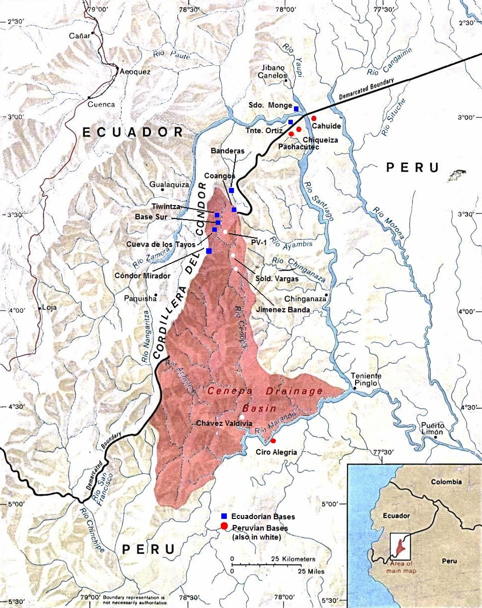
Most of the fighting of the Cenepa war was centered around the control of several outposts located on the headwaters of the Cenepa River (see map), a highland area covered with dense Amazonian jungle, inside a 78 km-long strip of territory where the process of demarcation between Ecuador and Peru remained stalled since 1951.
One of the outposts causing the dispute, called Tiwintza by the Ecuadorians, and Tiwinza by the Peruvians, came to symbolize the war because of the bitter clashes that took place around it, and the emotional importance that both sides attached to its possession. The conflict continued until the signing of a ceasefire and the eventual separation of forces, supervised by the MOMEP, a multinational mission of military observers from the "guarantor" countries of the 1942 Rio Protocol: Argentina, Brazil, Chile, and the USA.
The Cenepa war produced far-reaching consequences for relations between Ecuador and Peru. Among the effects of the war that paved the way for a definitive settlement of the border issues included the military outcome of the brief conflict; the lack of vindication of the Ecuadorian armed forces after the disappointing results of the wars of 1858, 1941, and 1981; and the Peruvians’ realization of the need for a resolution of a problem. Thus, in the aftermath of the war, both nations, brokered by the "guarantors" of the Rio Protocol, entered into a long and difficult negotiation process that concluded with the signing of a Peace Treaty in 1998, and the closing of the hitherto un-demarcated stretch of common border, deep in the Amazonian rainforest.
Hub AI
Cenepa War AI simulator
(@Cenepa War_simulator)
Cenepa War
The Cenepa War or Third Ecuadorian-Peruvian War (26 January – 28 February 1995), also known as the Alto Cenepa War, was a brief and localized military conflict between Ecuador and Peru, fought over control of an area in Peruvian territory (i.e. in the eastern side of the Cordillera del Cóndor, Province of Condorcanqui, Región Amazonas, Republic of Perú) near the border between the two countries. The two nations had signed a border treaty following the Ecuadorian–Peruvian War of 1941, but Ecuador later disagreed with the treaty as it applied to the Cenepa and Paquisha areas, and in 1960 it declared the treaty null and void. Most of the fighting took place around the headwaters of the Cenepa River.
Mediation efforts of Argentina, Brazil, Chile and the United States paved the way for the opening of diplomatic conversations that ultimately led to the signing of a definitive peace agreement (the Brasilia Presidential Act) on 26 October 1998. The peace agreement saw some of the territory being leased to Ecuador for a time. It was followed by the formal demarcation of the border on 13 May 1999 and the end of the multinational MOMEP (Military Observer Mission for Ecuador and Peru) troop deployment on 17 June 1999, which effectively put an end to one of the longest territorial disputes in the Western Hemisphere.
Official estimates give a death toll of 94. Demining was completed in 2024. As of 2025, it is the most recent military conflict in the Americas between countries contesting sovereignty over territory.
The Cenepa War was the most recent military clash between Ecuador and Peru over a long-standing territorial dispute that dated back to the first decades of the 19th century, when both countries came into being after the Wars of Independence of the Spanish colonies in South America.
In modern times there were three previous military confrontations: war between 1857 and 1860, a full-scale war in 1941, the Paquisha War in 1981, both of which had seen the Peruvian military forces prevailing over the Ecuadorian military.
Most of the fighting of the Cenepa war was centered around the control of several outposts located on the headwaters of the Cenepa River (see map), a highland area covered with dense Amazonian jungle, inside a 78 km-long strip of territory where the process of demarcation between Ecuador and Peru remained stalled since 1951.
One of the outposts causing the dispute, called Tiwintza by the Ecuadorians, and Tiwinza by the Peruvians, came to symbolize the war because of the bitter clashes that took place around it, and the emotional importance that both sides attached to its possession. The conflict continued until the signing of a ceasefire and the eventual separation of forces, supervised by the MOMEP, a multinational mission of military observers from the "guarantor" countries of the 1942 Rio Protocol: Argentina, Brazil, Chile, and the USA.
The Cenepa war produced far-reaching consequences for relations between Ecuador and Peru. Among the effects of the war that paved the way for a definitive settlement of the border issues included the military outcome of the brief conflict; the lack of vindication of the Ecuadorian armed forces after the disappointing results of the wars of 1858, 1941, and 1981; and the Peruvians’ realization of the need for a resolution of a problem. Thus, in the aftermath of the war, both nations, brokered by the "guarantors" of the Rio Protocol, entered into a long and difficult negotiation process that concluded with the signing of a Peace Treaty in 1998, and the closing of the hitherto un-demarcated stretch of common border, deep in the Amazonian rainforest.