Recent from talks
Comrie, Perth and Kinross
Knowledge base stats:
Talk channels stats:
Members stats:
Comrie, Perth and Kinross
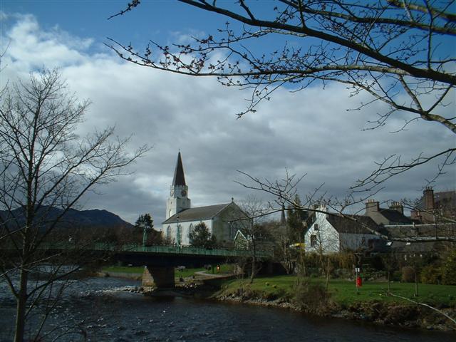
Comrie (/ˈkʌmri/; Scottish Gaelic: Comaraidh; Pictish: Aberlednock; Latin: Victoria) is a village and parish in the southern Highlands of Scotland, towards the western end of the Strathearn district of Perth and Kinross, 7 mi (11 km) west of Crieff.
Comrie is a historic conservation village in a national scenic area along the River Earn. The village's position on the Highland Boundary Fault causes it to experience more tremors than anywhere else in Britain, thus, it is nicknamed the "Shaky Toun" or "Am Baile Critheanach" in Gaelic. The parish is twinned with Carleton Place in Ontario, Canada.
Comrie lies within the registration county of Perthshire (Gaelic: Siorrachd Pheairt) and the Perth and Kinross local council area. The name Comrie derives from the original Gaelic name con-ruith or comh-ruith (from con/comh 'together', and ruith "to run", "running") translating literally as "running together", but more accurately as "flowing together" or "the place where rivers meet". In modern Gaelic the name is more often transcribed as Comaraidh, Cuimridh or Cuimrigh. This is apt as the village sits at the confluence of three rivers.
The River Ruchill (Scottish Gaelic: Abhainn Rùchail) and the River Lednock (Allt Liadnaig) are both tributaries of the Earn (Uisge Èireann) at Comrie, which itself eventually feeds into the Tay (Uisge Tatha).
Due to its position astride the Highland Boundary Fault, Comrie undergoes frequent earth tremors and has an old nickname of "Shaky Toun/Toon" (Scots) or 'Am Baile Critheanach' (Gaelic). In the 1830s around 7,300 tremors were recorded and today Comrie records earth tremors more often and to a higher intensity than anywhere else in the United Kingdom. Comrie became the site of one of the world's first seismometers in 1840, and a functional replica is still housed in the Earthquake House in The Ross in Comrie. The position of Comrie on the Highland Boundary Fault also gives the village a claim to the contested title of Gateway to the Highlands. To the north of the village, Ben Chonzie and the Grampian Mountains rise majestically, while to the south of the village broad open moorland is joined by lesser mountains and glens that provide a wide range of terrain and ecology.
There is significant evidence of prehistoric habitation of the area, marked by numerous standing stones and archaeological remains that give insight into the original prehistoric, Pictish and later Celtic societies that lived here.
In AD 79, the Roman General Agricola chose what are now the outskirts of Comrie as the site for a fort and temporary marching camp, due to the area's strategic position on the southern fringe of the Highlands. It is one of the line of so-called "Glen blocking" forts running from Drumquhassle to Stracathro and including the legionary fortress of Inchtuthil. The temporary camp was c. 22 acre (c. 9 ha) in size. An infamous battle between the Celts and Romans is known to have occurred on the unidentified mountain Mons Graupius. The area around Comrie, Strathearn, is one of several proposed battle sites.
James V of Scotland came to Comrie and Cultybraggan regularly in September to hunt deer. Records survive of the food he consumed included bread, ale and fish sent from Stirling. His consort Mary of Guise and her ladies in waiting also came to the hunting in Glenartney. A "Hunt Hall" for the use of Mary, Queen of Scots, was built in Glenartney by James Stewart, 1st Lord Doune in August 1563.
Hub AI
Comrie, Perth and Kinross AI simulator
(@Comrie, Perth and Kinross_simulator)
Comrie, Perth and Kinross
Comrie (/ˈkʌmri/; Scottish Gaelic: Comaraidh; Pictish: Aberlednock; Latin: Victoria) is a village and parish in the southern Highlands of Scotland, towards the western end of the Strathearn district of Perth and Kinross, 7 mi (11 km) west of Crieff.
Comrie is a historic conservation village in a national scenic area along the River Earn. The village's position on the Highland Boundary Fault causes it to experience more tremors than anywhere else in Britain, thus, it is nicknamed the "Shaky Toun" or "Am Baile Critheanach" in Gaelic. The parish is twinned with Carleton Place in Ontario, Canada.
Comrie lies within the registration county of Perthshire (Gaelic: Siorrachd Pheairt) and the Perth and Kinross local council area. The name Comrie derives from the original Gaelic name con-ruith or comh-ruith (from con/comh 'together', and ruith "to run", "running") translating literally as "running together", but more accurately as "flowing together" or "the place where rivers meet". In modern Gaelic the name is more often transcribed as Comaraidh, Cuimridh or Cuimrigh. This is apt as the village sits at the confluence of three rivers.
The River Ruchill (Scottish Gaelic: Abhainn Rùchail) and the River Lednock (Allt Liadnaig) are both tributaries of the Earn (Uisge Èireann) at Comrie, which itself eventually feeds into the Tay (Uisge Tatha).
Due to its position astride the Highland Boundary Fault, Comrie undergoes frequent earth tremors and has an old nickname of "Shaky Toun/Toon" (Scots) or 'Am Baile Critheanach' (Gaelic). In the 1830s around 7,300 tremors were recorded and today Comrie records earth tremors more often and to a higher intensity than anywhere else in the United Kingdom. Comrie became the site of one of the world's first seismometers in 1840, and a functional replica is still housed in the Earthquake House in The Ross in Comrie. The position of Comrie on the Highland Boundary Fault also gives the village a claim to the contested title of Gateway to the Highlands. To the north of the village, Ben Chonzie and the Grampian Mountains rise majestically, while to the south of the village broad open moorland is joined by lesser mountains and glens that provide a wide range of terrain and ecology.
There is significant evidence of prehistoric habitation of the area, marked by numerous standing stones and archaeological remains that give insight into the original prehistoric, Pictish and later Celtic societies that lived here.
In AD 79, the Roman General Agricola chose what are now the outskirts of Comrie as the site for a fort and temporary marching camp, due to the area's strategic position on the southern fringe of the Highlands. It is one of the line of so-called "Glen blocking" forts running from Drumquhassle to Stracathro and including the legionary fortress of Inchtuthil. The temporary camp was c. 22 acre (c. 9 ha) in size. An infamous battle between the Celts and Romans is known to have occurred on the unidentified mountain Mons Graupius. The area around Comrie, Strathearn, is one of several proposed battle sites.
James V of Scotland came to Comrie and Cultybraggan regularly in September to hunt deer. Records survive of the food he consumed included bread, ale and fish sent from Stirling. His consort Mary of Guise and her ladies in waiting also came to the hunting in Glenartney. A "Hunt Hall" for the use of Mary, Queen of Scots, was built in Glenartney by James Stewart, 1st Lord Doune in August 1563.
Recent media