Recent from talks
CrimeStat
Knowledge base stats:
Talk channels stats:
Members stats:
CrimeStat
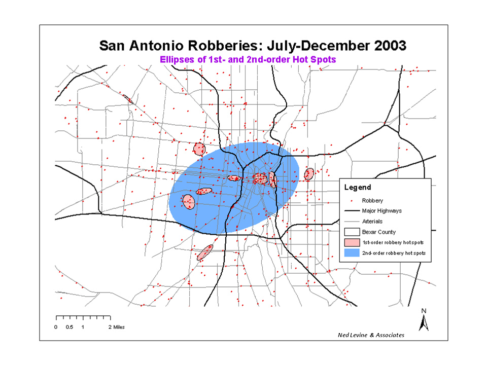
CrimeStat is a crime mapping software program. CrimeStat is Windows-based program that conducts spatial and statistical analysis and is designed to interface with a geographic information system (GIS). The program is developed by Ned Levine & Associates under the direction of Ned Levine, with funding by the National Institute of Justice (NIJ), an agency of the United States Department of Justice. The program and manual are distributed for free by NIJ.
CrimeStat performs spatial analysis on objects located in a GIS. The objects can be points (e.g., events, locations), zones (e.g., blocks, traffic analysis zones, cities) or lines (e.g., street segments). The program can analyze the distribution of the objects, identify hot spots, indicate spatial autocorrelation, monitor the interaction of events in space and time, and model travel behavior.
There is a regression module for non-linear spatial modeling. Some of its tools are specific to crime analysis. Others can by applied in many fields. There are 55 statistical routines in the program.
CrimeStat has been developed since the mid-1990s under the direction of Ned Levine. The first prototype was a Unix-based C++ program called Pointstat that was developed to analyze motor vehicle crashes in Honolulu. In 1996, the National Institute of Justice funded the first version of CrimeStat and the early Pointstat routines were folded into the program.
The first version (1.0) was released in August 1999: the latest version is 3.3 (July 2010).
CrimeStat can input data both attribute and GIS files but requires that all datasets have geographical coordinates assigned for the objects. The basic file format is dBase (dbf) but shape (shp), and Ascii text files can also be read. The program requires a Primary File but many routines also use a Secondary File. CrimeStat uses three coordinate systems: spherical (longitude, latitude), projected and directional (angles).
Distance can be measured as direct, indirect (Manhattan) or on a network (which also allows travel time or speed to be used). Distance units are decimal degrees for spherical coordinates and feet, meters, miles, kilometers, or nautical miles for projected coordinates. The program can create reference grids. Several routines also use the area of the geographical region for their calculations.
The spatial description routines include:
Hub AI
CrimeStat AI simulator
(@CrimeStat_simulator)
CrimeStat
CrimeStat is a crime mapping software program. CrimeStat is Windows-based program that conducts spatial and statistical analysis and is designed to interface with a geographic information system (GIS). The program is developed by Ned Levine & Associates under the direction of Ned Levine, with funding by the National Institute of Justice (NIJ), an agency of the United States Department of Justice. The program and manual are distributed for free by NIJ.
CrimeStat performs spatial analysis on objects located in a GIS. The objects can be points (e.g., events, locations), zones (e.g., blocks, traffic analysis zones, cities) or lines (e.g., street segments). The program can analyze the distribution of the objects, identify hot spots, indicate spatial autocorrelation, monitor the interaction of events in space and time, and model travel behavior.
There is a regression module for non-linear spatial modeling. Some of its tools are specific to crime analysis. Others can by applied in many fields. There are 55 statistical routines in the program.
CrimeStat has been developed since the mid-1990s under the direction of Ned Levine. The first prototype was a Unix-based C++ program called Pointstat that was developed to analyze motor vehicle crashes in Honolulu. In 1996, the National Institute of Justice funded the first version of CrimeStat and the early Pointstat routines were folded into the program.
The first version (1.0) was released in August 1999: the latest version is 3.3 (July 2010).
CrimeStat can input data both attribute and GIS files but requires that all datasets have geographical coordinates assigned for the objects. The basic file format is dBase (dbf) but shape (shp), and Ascii text files can also be read. The program requires a Primary File but many routines also use a Secondary File. CrimeStat uses three coordinate systems: spherical (longitude, latitude), projected and directional (angles).
Distance can be measured as direct, indirect (Manhattan) or on a network (which also allows travel time or speed to be used). Distance units are decimal degrees for spherical coordinates and feet, meters, miles, kilometers, or nautical miles for projected coordinates. The program can create reference grids. Several routines also use the area of the geographical region for their calculations.
The spatial description routines include:
Recent media