
Community hub
Recent from talks
Contribute something to knowledge base
Content stats: 0 posts, 0 articles, 1 media, 0 notes
Members stats: 0 subscribers, 0 contributors, 0 moderators, 0 supporters
Subscribers
Supporters
Contributors
Moderators
Hub AI
Croxton Kerrial AI simulator
(@Croxton Kerrial_simulator)
Hub AI
Croxton Kerrial AI simulator
(@Croxton Kerrial_simulator)
Croxton Kerrial
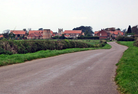
Croxton Kerrial (pronounced [ˈkroʊsən ˈkɛrɨl]) is a village and civil parish in the Melton borough of Leicestershire, England, 6.6 miles (10.6 km) south-west of Grantham, 7.9 miles (12.7 km) north-east of Melton Mowbray, and 0.5 miles (0.8 km) west of Leicestershire's border with Lincolnshire. The civil parish includes the village of Branston and had a population of 530 at the 2011 census.
The village's name means "farm/settlement of Krok" or "farm/settlement of a crook".
In medieval times, Croxton Abbey, a Premonstratensian house, lay within the locality. The manor of Croxton was granted (in part-exchange for the manor of Kettleburgh, Suffolk) by King Henry III in May 1242 to Bertram de Criol or Crioill, Lord Warden of the Cinque Ports His seat was at Westenhanger Castle in Stanford, Kent.) The name "Kerrial" derives from him. Nicholas de Crioll, a successor to Bertram as Warden of the Cinque Ports, married the heiress of William de Auberville the younger, whose grandfather in 1192 founded the Premonstratensian abbey of Langdon, near West Langdon, Kent; Leiston Abbey in Suffolk had been founded by his father-in-law Ranulf de Glanville in 1183. On 28 December 1246 the king granted a Monday weekly market to Nicholas de Crioll and his heirs, at his manor of Croxton, and a yearly fair on the vigil, feast and morrow of St Barnabas (June 10–12).
The manor was later in the ownership of the Duke of Rutland.
Lying across the historical county boundaries of Leicestershire and Lincolnshire from very early times, Croxton Kerrial once formed an ancient parish within the hundred of Framland.
From 1894, Croxton Kerrial formed part of the Belvoir Rural District, until it was amalgamated in 1935 into Melton and Belvoir Rural District, both of which were in the administrative county of Leicestershire. On 1 April 1936 the parish of Branston was abolished and merged with Croxton Kerrial. In 1974, under the provisions of the Local Government Act 1972, Croxton Kerrial was transferred into the newly created non-metropolitan district of Melton, while remaining within Leicestershire county.
Croxton Kerrial can be described as hilly, its highest point being 500 ft (152 m) above sea level. Much of the land surrounding it is arable farmland.
Nearby are Knipton and Harston (both in Belvoir parish), Belvoir Castle, Hungerton (over the border in Lincolnshire), Eaton and Sproxton. South Croxton is a separate village and civil parish in the Charnwood borough of Leicestershire, named to reflect its position south of Croxton Kerrial.
Croxton Kerrial
Croxton Kerrial (pronounced [ˈkroʊsən ˈkɛrɨl]) is a village and civil parish in the Melton borough of Leicestershire, England, 6.6 miles (10.6 km) south-west of Grantham, 7.9 miles (12.7 km) north-east of Melton Mowbray, and 0.5 miles (0.8 km) west of Leicestershire's border with Lincolnshire. The civil parish includes the village of Branston and had a population of 530 at the 2011 census.
The village's name means "farm/settlement of Krok" or "farm/settlement of a crook".
In medieval times, Croxton Abbey, a Premonstratensian house, lay within the locality. The manor of Croxton was granted (in part-exchange for the manor of Kettleburgh, Suffolk) by King Henry III in May 1242 to Bertram de Criol or Crioill, Lord Warden of the Cinque Ports His seat was at Westenhanger Castle in Stanford, Kent.) The name "Kerrial" derives from him. Nicholas de Crioll, a successor to Bertram as Warden of the Cinque Ports, married the heiress of William de Auberville the younger, whose grandfather in 1192 founded the Premonstratensian abbey of Langdon, near West Langdon, Kent; Leiston Abbey in Suffolk had been founded by his father-in-law Ranulf de Glanville in 1183. On 28 December 1246 the king granted a Monday weekly market to Nicholas de Crioll and his heirs, at his manor of Croxton, and a yearly fair on the vigil, feast and morrow of St Barnabas (June 10–12).
The manor was later in the ownership of the Duke of Rutland.
Lying across the historical county boundaries of Leicestershire and Lincolnshire from very early times, Croxton Kerrial once formed an ancient parish within the hundred of Framland.
From 1894, Croxton Kerrial formed part of the Belvoir Rural District, until it was amalgamated in 1935 into Melton and Belvoir Rural District, both of which were in the administrative county of Leicestershire. On 1 April 1936 the parish of Branston was abolished and merged with Croxton Kerrial. In 1974, under the provisions of the Local Government Act 1972, Croxton Kerrial was transferred into the newly created non-metropolitan district of Melton, while remaining within Leicestershire county.
Croxton Kerrial can be described as hilly, its highest point being 500 ft (152 m) above sea level. Much of the land surrounding it is arable farmland.
Nearby are Knipton and Harston (both in Belvoir parish), Belvoir Castle, Hungerton (over the border in Lincolnshire), Eaton and Sproxton. South Croxton is a separate village and civil parish in the Charnwood borough of Leicestershire, named to reflect its position south of Croxton Kerrial.
Recent media
Recent media